

Volume 10 No. 3 – August 1, 1937All material courtesy of the National Park Service. These publications can also be found at http://npshistory.com/Nature Notes is produced by the National Park Service. © 1937 |
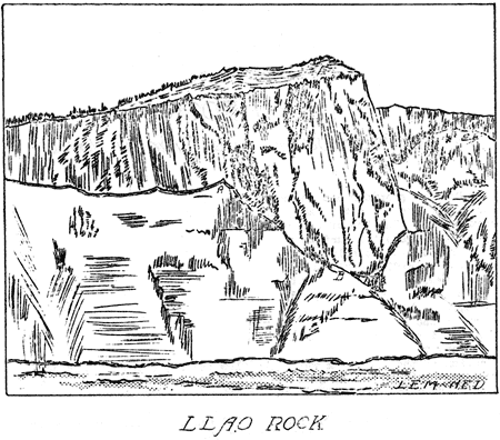
Cover – Llao Rock by Nancy Elliott Doerr
Preface
By John E. Doerr, Jr., Editor
Crater Lake National Park
The park includes an area of 250 square miles on the crest of the Cascade Range in southern Oregon. The area was established as a national park in 1902, preserving the unsurpassed scenic beauty of Crater Lake, a deep lake, the clear fresh water of which reflects and refracts unusual hues of blue. Color is only one of the elements of the inspiring beauty of Crater Lake. Its setting is unique. The lake, having an area of 20 square miles, is cupped within the crater of an extinct volcano. Cliffs 500 to 2000 feet high completely surround the lake. The crater walls are partially mantled with hemlock, fir, and pine trees. On the gentle outer slopes of the mountain which one ascends in approaching Crater Lake there are deep canyons, magnificent forests and open meadows supporting a colorful display of mountain wild flowers. Hiking and fishing are popular outdoor sports during the summer months. Skiing is popular in the winter, and the park being accessible throughout the winter months by the west entrance road from Medford and the south entrance road from Klamath Falls.
Oregon Caves National Monument
This national monument, an area of 480 acres, is located in the Siskiyou Mountains in southwestern Oregon. The caves, named “The Marble Halls of Oregon” by Joaquin Miller, are truly marble halls. Underground water penetrating to great depth along fractures in the marble formation has dissolved out an extensive system of chambers. Water dripping from the ceiling and walls has decorated the halls and passageways with fantastic stalactites and stalagmites which stimulate one’s imagination as well as one’s appreciation of the beauties of nature in caverns never touched by sunlight. In the magnificent forest around the cave entrance there are trails along which one gets inspiring views of forest-covered mountains and valleys. Along the trails one can observe many species of trees, mammals, and birds.
Lava Beds National Monument
Located in northeastern California, the monument includes an area of 45,000 acres. As the name suggests, volcanic formations, some of quite recent origin, are of greatest importance. There are hundreds of lava tubes which were once the passageways for streams of molten lava. Volcanic cones rise above the general level of the adjacent country. There are excellent examples of “aa” and “pahoehoe” lava flows. Within the monument there are interesting historical features including battlefields of the Modoc War of 1872-73. There are important ethnological and archaeological features. Petroglyphs on cliffs and pictographs in caves are evidence that the region was inhabited by primitive people long before the coming of the white man.
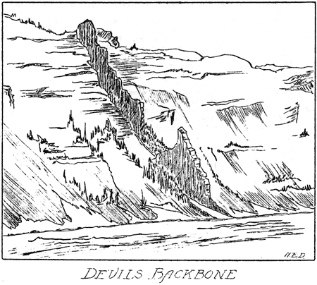
Llao Rock, A Lava Flow Burying A Glacial Valley
By Wayne E. Kartchner, Ranger Naturalist, 1936-1937

Massive grandeur and sheerness combine to make Llao Rock, on the northwest side of Crater Lake, one of the outstanding features of the crater wall. The top of the rock, 8,046 feet above sea level, stands 1,884 feet above the surface of the lake.
In addition to being an impressive scenic features, Llao Rock is of great significance in the in the interpretation of the events that took place during the building of Mount Mazama, the name given to the peak, the destruction of which resulted in the crater in which Crater Lake is cupped. Llao Rock is a dacite lava flow, one of the most recent flows on the slopes of Mount Mazama. The evidence indicating whether the flow issued from the summit crater of the ancient peak or from a secondary vent on the slope has been destroyed. Regardless of the location of the vent from which the flow issued, there is distinct evidence that the dacite lava in moving down the mountain followed the course of a valley carved by a glacier. A sufficient quantity of lava issued to completely fill and overflow the glacial valley which has been carved to a depth of 500 to 600 feet, the maximum thickness of the flow being approximately 1,200 feet.
The conclusive evidence that the flow buried a glacial valley is as follows: (1) The cross-section of the base of the flow is distinctly U-shaped. Such a cross-section is characteristic of valleys carved by alpine glaciers. (2) Glacial scratches occur on rock surfaces on which the flow rests. The existence of glacial striations at points marked A and B on the sketch of Llao Rock which appears on the following page was determined by Ranger Naturalist Loren F. Miller. (3) Several feet of morainal material (glacial till) occurs immediately below the flow at the point marked B on the sketch.
The question has arisen as to whether the flow occurred while a glacier occupied the valley. Observations indicate that there was no glacier in the valley at the time of the flow. There is distinct evidence that the viscous lava came in contact with the morainal material, pebbles and small boulders being partially embedded in the underneath surface of the flow. Had ice existed in the valley at the time of the flow there would undoubtedly be evidence of caves formed as the ice melted out beneath the flow. Evidence of such caves is entirely lacking.
From the evidence presented it may be concluded that Llao Rock represents a recent lava flow which filled and buried a glacial valley carved to a depth of 500 to 600 feet on the northwest slope of Mount Mazama, and that the flow occurred when the valley was free of ice.
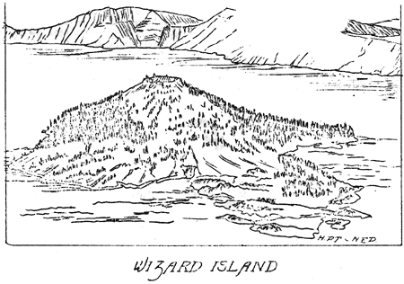
Mammals On Wizard Island
By R. R. Huestis, Ranger Naturalist
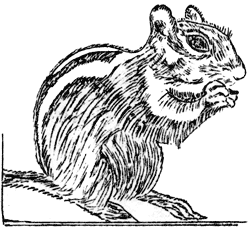 On July 28, 1937, twenty delusion (live) mouse traps were set along the trail leading to the top of Wizard Island. The traps were set among lava rocks and under logs. These traps took two adult female Mazama red-backed mice, Clethrionomys californicus mazama (Merriam). These mice are relatively rare specimens in trap-lines and very little is known about their life history. It is an interesting fact that the type specimen of this subspecies was taken by C. Hart Merriam and Vernon Bailey on the south side of Crater Lake, August 15, 1896. The two trapped specimens closely resemble in color and measurements the specimens described by Bailey.* The measurements tabulated below are in millimeters. Three of four species of diurnal mammals have been reported as living on Wizard Island in Crater Lake. The mammals are, the brown coney, Ochotona princeps brunnescens Howell; the golden-mantled ground squirrel, Callospermophilus chrysodeirus chrysodeirus (Merriam); and a chipmunk. The latter might be Allen’s Chipmunk, Eutamias townsendii senex (Allen), or the smaller Eutamias amoenus amoenus (Allen), the Klamath Chipmunk. Both species of chipmunks may have been seen.
| Total Length | Tail Vertebrae | Foot | Ear |
| 162.8 | 51.5 | 19.0 | 11.2 |
| 157.2 | 53.7 | 18.4 | 12.0 |
It may be seen from the above that the two specimens of Mazama red-backed mice have tails about one-half the length of the body and small ears. They also have small eyes. They are bright reddish brown along the back with greyer flanks and a pale cream-colored ventral surface.
On August 8 twenty delusion mouse traps and twenty large and small snap traps were set on the north slope of Wizard Island. The delusion traps took four deer mice, Peromyscus maniculatus ssp., and the snap traps took one Peromyscus, some coneys and golden-mantled ground squirrels. Only one Peromyscus was an adult. It measured 172.3 x 81.8 x 22.3 x 18.4. These measurements are duplicated by specimens taken along the rim; in color the specimen presented no obvious differences from the mainland type. No chipmunks were taken at this time nor in a previous night’s trapping, and none have been seen on the island this year (1937).
The mammalian fauna of Wizard Island is interesting because no one knows how the animals got there. Coneys are common inside the rim of Crater Lake but they never venture any distance from the home rock slide. Swimming Skell Channel, the narrowest arm of water between the island and the mainland, would be quite out of character for them. It seems improbable that they would venture out of their winter retreats and cross the island on ice. Golden-mantled ground squirrels are in hibernation in the winter. It seems quite improbable that they would swim across although this method of transportation may be possible. Peromyscus swim readily. They could easily have been transported by a boat, a method of travel which would also be open to squirrels and chipmunks. The habits of red-backed mice are insufficiently know to venture comment on how they got to Wizard Island.
While visiting the island during the summer months Dr. R. M. Bond found signs indicating the presence of either a fox or a bobcat. It seems quite possible that a more extended investigation might show, in addition to deer mice, Mazama red-backed mice, ground squirrels, and coneys, the presence of which has already been determined, or past occupancy, of still other mammals of Wizard Island.
*Bailey, Vernon, The Mammals and Life Zones of Oregon, N. Amer. Fauna No. 55, U.S.D.A. Bur. of Biol. Sur., June 1936.
![]()
Varved Clays Near The Devil’s Backbone
By Randall E. Brown, Student Technician, 1937*
On the west rim of Crater Lake, approximately 600 feet south of the Devil’s Backbone and 200 feet below the rim of the crater, there is a deposit of varved clays which resemble the typical varved clays associated with glacial deposits.
These clays are limited in extent, the greatest exposure being nearly six feet in thickness and thirty feet wide. Beyond, a mantle of brush obliterates all trace of the clays. Farther south of the exposure a lava flow rises above the elevation of the clay deposit. No trace of the clays can be found either at that point or farther south.
The thick growth of brush is due to moisture issuing at the top of the clay. Since the material above is definitely glacial in that it consists of typical morainal debris, it accordingly is more porous than the clay. The spring which supplies water for the North Entrance Ranger Station issues at the top of the clay deposit. In general the structure of the crater wall favors a westward drainage away from the lake; however, there may have been a small basin in which the clay was deposited which causes drainage toward the lake. Such a feature would be only local in character.
In both directions, north and south of the exposed varved clays, toward the Devil’s Backbone and Hillman Peak respectively, the glacial deposits are more sandy, although a few irregular sand clay layers may be traced through the deposits. In several places, the most notable of which occurs along the trail to the spring, there are deposits of well stratified, water deposited sand. These glacial and fluvio-glacial deposits are further evidence that the entire western slope of Mount Mazama was covered by ice having a thickness of several hundred or perhaps a thousand feet in places. Morainal deposits to the southwest of Hillman Peak certainly indicate extensive glaciation on the west slope of the ancient peak. Only Watchman and Hillman, the two peaks on the west rim of Crater Lake may have projected above the ice sheet.
The varved clays rest on a series of lava flows. No glacial striae were found on the surface of the flow directly beneath the clays. The banding in the clays is uniform and regular, the varves being evenly spaced. The varved character of the deposit indicates definitely deposition of fine sediment in a body of quiet standing water. Such a body of water may have existed during an inter-glacial stage, the water being held in place by morainal material and the ice. During an advance of the ice they clays, if frozen, may have remained undisturbed by the overriding ice. There is also the possibility that the deposit represents deposition in a dammed subglacial stream beneath stagnant ice, in which case the glacial debris above the clays settled out of the ice as it melted.
The section including the varved clays, the glacial drift above and the underlying lava flows, was exposed when the peak of Mount Mazama was destroyed.
*During the summer of 1937 the Civilian Conservation Corps provided funds for employing college students majoring in some particular field of work. Mr. Brown served as a Student Technician in Geology, his activities being under the direct supervision of the Naturalist staff of Crater Lake National Park.
Outline Of Events In The History Of The Modoc War
John E. Doerr, Jr., Park Naturalist

(Continued from the July 1937 issue of Nature Notes)
Parts I and II of this outline appeared in the June and July 1937 issues of Nature Notes. The first part covered the period 1846 – 1870, the second part 1871 to April 12, 1873, ending with the murder of General E. R. S. Canby and Reverend E. Thomas at the peace tent within what is now Lava Beds National Monument.
This part concludes the outline of events in the history of the Modoc War, a struggle which began in 1846 when the South Emigrant Trail, (Applegate Trail) was established through the Klamath Basin of southern Oregon and northern California, and ending with the death of some and exile of the other members of Captain Jack’s band of Modoc Indians.
Part III
April 12 – October 3, 1873
| 1873 April | Attack on The Stronghold. |
| Treachery on the part of the Modocs resulting in the death of General E. R. S. Canby and Reverend E. Thomas on April 11, 1873, ended the efforts of the Peace Commission. The U. S. Army made preparations to attack The Stronghold. On April 15 a general attack began, troops advancing from Gillem’s camp on the west and Mason’s camp at Hospital Rock, northeast of The Stronghold. Fighting continued throughout the day, the troops remaining in position during the night. Each advance of troops on the 16th was under heavy fire from the Modoc positions. That night the troops succeeded in cutting the Indians off from their water supply at the shore of Tule Lake. By the morning of April 17 everything was in readiness for the final attack on The Sronghold. When the order was given to advance, the troops charged into The Stronghold. | |
| The Stronghold Abandoned. | |
| After the fighting along the shoreline of Tule Lake on the afternoon and night of April 16, the Modocs defending The Stronghold realized that their water supply had been cut off by the troops commanding the shoreline. On April 17, before the troops had received the order to charge The Stronghold, the Indians escaped through a crevice left unguarded during a movement of troops from one position to another. During the fighting at The Stronghold, April 15 – 17, casualties included one officer and six enlisted men killed, and thirteen enlisted men wounded. The Indians suffered no casualties, except one boy, reported to have been killed when a cannon ball, which he was attempting to open with an axe, exploded. Several Modoc women were reported to have died from sickness. | |
| Thomas-Wright Massacre, April 26, 1973. | |
| On April 26 Captain Evan Thomas commanding five officers, sixty-six troops and fourteen Warm Spring Scouts left Gillem’s camp on a reconnaissance of the lava beds to locate the Indians. While eating lunch in a flat area surrounded by ridges, Captain Thomas and his party were attacked. Some of the troops fled in disorder. Those who remained to fight were either killed or wounded. Casualties included four officers killed and two wounded, one dying within a few days, and thirteen enlisted men killed and sixteen wounded. | |
| May | On May 2 General Jefferson C. Davis relieved Col. Alvin C. Gillem of the command of troops in the lava beds.U. S. troops and members of Captain Jack’s band of Modocs skirmished at Scorpion Point, May 7.General Davis ordered a reconnaissance to locate the Indians.Battle of Dry Lake. |
| As daylight on May 10 the Indians attacked the troops camped at Dry Lake. The troops charged, routing the Indians. Casualties among the troops included five men killed, two of whom were Warm Spring Scouts, and twelve men wounded. The Indians reported five warriors killed. Among the five was Ellen’s Man, a prominent Modoc. That was the first defeat of the Modocs in battle. The death of Ellen’s Man caused dissension among the Indians. | |
| June | Captain Jack captured in Langell’s valley, June 4.Preparations made to execute the Modoc leaders. |
| With the capture of Captain Jack, General Davis made preparations to execute the leaders of Jack’s band. Execution was prevented by orders from the War Department. The orders were that the Indians would be held for trail. | |
| July | Modoc prisoners arrived at Fort Klamath. |
| On July 4 Captain Jack and his band of Indians arrived as prisoners of war at Fort Klamath. | |
| Trial. | |
| Captain Jack, John Schonchin, Black Jim, Boston Charley, Brancho (Barncho) and Slolux were immediately put on trial for the murder of members of the Peace Commission. The six Indians were found guilty, and on July 8 they were sentenced to die. | |
| September | |
| On September 10 President U. S. Grant approved the death sentence for Captain Jack, John Schonchin, Black Jim and Boston Charley; Brancho and Slolux were committed to life imprisonment. President Grant also ordered that the remainder of Captain Jack’s band be held as prisoners of war. | |
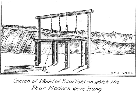
| October | The End. |
| On October 3, 1873, Captain Jack, John Schonchin, Black Jim, and Boston Charley were hanged at Fort Klamath. The remainder of the band of Modoc Indians, consisting of 39 men, 64 women, and 60 children, as prisoners of war were sent to the Quaw Paw Agency in Indian Territory (Oklahoma). | |
Appendix to the Outline of Events in the History of the Modoc War
In the attack on The Stronghold, January 17, 1873, there were approximately 400 troops in the field. The troops included U. S. Army infantry, cavalry, and howitzer units; Oregon and California volunteer companies, and some Klamath Indian Scouts. Lt. Col. Frank Wheaton was in command of all troops.
In the capture of The Stronghold, April 17, 1873, approximately 530 troops were engaged. These included U. S. Army infantry, cavalry, and artillery, and Warm Spring Indian Scouts. The volunteer companies had withdrawn from the field. A small number of civilians were used as runners and packers. Col. Alvin C. Gillem was in command.
At no time during the Modoc War were there more than 53 Modoc warriors engaged in the fighting.
The casualty lists for the Modoc War are as follows:
| Rank | Killed | Wounded |
| Officers (U.S.A.) | 7 | 4 |
| Enlisted Men | 39 | 61 |
| Civilians | 16 | 1 |
| Indian Scouts | 2
|
0
|
| 64 | 66 |
Including the four Indians hung at Fort Klamath, Captain Jack’s band suffered the loss of seventeen warriors killed.
It has been estimated that the Modoc War cost the United States over $4,000,000; a very expensive war in terms of lives and dollars, considering the small number of opposing forces.
Battlefields of the Modoc War are among the outstanding features of the Lava Beds National Monument. These include The Stronghold in and around which one can see the numerous cracks, ridges, and knobs used by the Indians in defending their position, numerous Modoc outpost fortifications, smoke-stained caves inhabited by the Indians during the months of the war, corrals in which the Indians kept cattle and horses, war-dance ground and council area. Around The Stronghold one can see numerous low stone fortifications built by troops advancing on The Stronghold, as well as numerous fortifications built by the troops after the evacuation of the Modocs, the fortifications built after evacuation being for the purpose of defending The Stronghold in the event that the Indians should attempt to return to their former strong defensive position. The Thomas-Wright Massacre battlefield, near Hardin Butte, is one of the interesting features of the monument; as is also the site of Gillem’s camp, the former military cemetery, Hospital Rock, and Canby’s Cross.
Fishing In Crater Lake, August 1937
By Arthur D. Hasler, Ranger Naturalist and John E. Doerr, Jr., Editor
![]()
In the July 1937 issue of Nature Notes Volume X, Number 2, appears an analysis of the records of fish caught from boats on Crater Lake during July 1937. The following chart is a similar analysis of the catch for August 1937.
This is the first season that a study extending over a two months period has been made of the fish caught in Crater Lake. With such studies, along with the investigation of other aspects of the biology of Crater Lake, continuing over several seasons, it should be possible to look forward to the time when many of the questions relative to the fish and fishing in Crater Lake can be answered.
ANALYSIS OF THE RECORDS OF CATCH FROM BOATS ON CRATER LAKE*
August 1937
|
|
||||
| No. of Boat Reports |
No. of Anglers |
Total Fishing Hours |
No. of Fish Taken |
Catch Per Angler Per Hour |
|
|
||||
| 318 | 666 | 794 | 535 | 0.67 |
|
|
||||
*From a seasonal report prepared by Ranger Naturalist Arthur D. Hasler, Crater Lake National Park, September 1937.
Errata
By W. T. Frost, Ranger and
John E. Doerr, Jr., Park Naturalist
![]()
The following data should be added and the indicated correction made to the data appearing in Nature Notes, Volume X, No. 1, June 1937, page 6.
| Year | Low Lake Level of the Year |
Number of Feet Below High Point of 1910 |
| 1931 | 6163.26 | 13.91 |
| 1932 | 6163.71 | 13.46 |
| 1933 | 6164.46 | 12.71 |
The lowest level on record was in 1931 rather than in 1934 as is indicated in the June 1937 issue of Nature Notes.
Web Edition Note: In the online edition of Nature Notes, June 1937, the table has already been corrected to reflect the above changes.
Other pages in this section