
DESCRIPTION: Mazama Ash
— from the USGS/Cascades Volcano Observatory website
 |
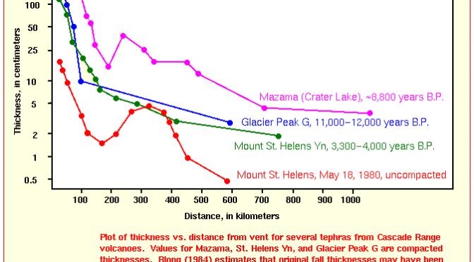
| Plot of thickness vs. distance from vent for several tephras from Cascade Range volcanoes; Modified from: Hoblitt, et.al., 1987, USGS Open-File Report 87-297 |
From: Hoblitt, Miller, and Scott, 1987, Volcanic Hazards with Regard to Siting Nuclear-Power Plants in the Pacific Northwest: USGS Open-File Report 87-297
A wide range of compositions and volumes of tephra have been erupted during the past 15,000 years from Cascade volcanoes. These tephra deposits range in volume from the 116 cubic kilometers Mazama tephra (Bacon, 1983; Druitt and Bacon, 1986) to those of only a few thousand cubic meters. The May 18, 1980 eruption of Mount St. Helens deposited an estimated minimum volume of 1.1 cubic kilometers of uncompacted tephra on areas east-northeast of the volcano (Sarna-Wojcicki and others, 1981). …
Crater Lake occupies a caldera formed 6,850 years ago during the climactic eruption of Mount Mazama which was a cluster of Pleistocene stratovolcanoes. …
During the few centuries preceding the climactic eruption, at least two small- to moderate-volume (<1 to several cubic kilometers) eruptions of rhyolite occurred in the area underlain by the magma chamber. Tephra from one of these eruptions extended into southeastern Oregon and western Nevada and the same tephra, or one or more others, fell as far away as eastern Washington. …
The climactic eruptions 6,850 years ago produced voluminous tephra-fall and pyroclastic-flow deposits. The tephra deposits are about 40 centimeters thick (15 inches) at points 200 kilometers (125 miles) northeast of the volcano and 4-5 centimeters thick (1.5 – 2 inches) at 1,000 kilometers (625 miles); layers have been found in 8 western states and 3 Canadian provinces. The tephra fall was followed by two episodes of pyroclastic-flow formation. The first was of small extent, but it was followed by voluminous pyroclastic flows that moved outward in all directions to distances of as much as 60 kilometers (40 miles). The total volume of magma erupted during the climactic eruption was about 50-60 cubic kilometers, which is an order of magnitude larger than that produced during any other explosive eruption in the Cascade Range during postglacial time.
Mazama Ash at Mount Bachelor
From: Scott and Gardner, 1990, Field trip guide to the central Oregon High Cascades, Part 1: Mount Bachelor-South Sister area: Oregon Geology, September 1990, v.42, n.5, p.99.
A shallow excavation in the southwest part of the West Village parking lot (at Mount Bachelor) contains a good exposure of Mazama ash, which serves as a valuable stratigraphic marker in the central High Cascades.
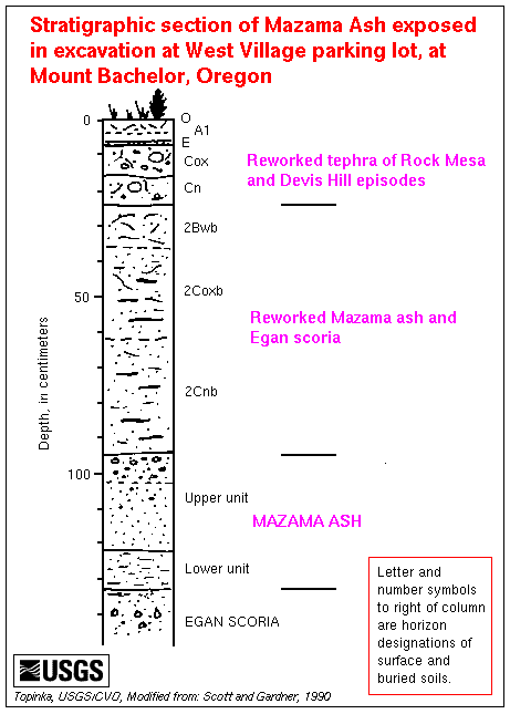 |
| Stratigraphic section of Mazama ash exposed in excavation at West Village parking lot, at Mount Bachelor. Letter and number symbols to right of column are horizon designations of surface and buried soils. — Modified from: Scott and Gardner, 1990 |
The age of Mazama ash is 6,845 +/- 50 carbon-14 years B.P. (Bacon, 1983; about 7,700 calendar years ago). The ash lies on unweathered or slightly weathered scoria from nearby Egan cone, the youngest vent of the Mount Bachelor volcanic chain. This lack of substantial weathering suggests that the tephra eruptions of Egan cone are only slightly older than Mazama ash. Mostly reworked Rock Mesa and Devils Hill tephra lies above Mazama ash.