
Mixing Dynamics in Crater Lake, Oregon
G.B. Crawford (Humboldt State University), with contributions from R.W. Collier (Oregon State University), G. Larson (USGS-NBS, Corvallis, Oregon), and a cast of several others 2003
A Brief Description of the Lake
Crater Lake is a closed-basin caldera lake set in the Cascade Mountains of south-central Oregon.
 |
|
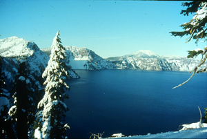
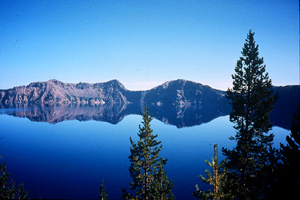
Fig. 1. Crater lake winter scene |
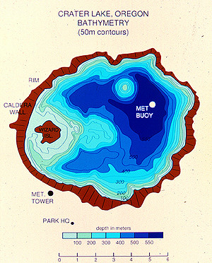
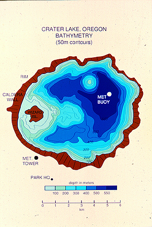
The lake lies within the boundary of Crater Lake National Park and is managed by the National Park Service (NPS). Formed by the eruption of Mt. Mazama roughly 7000 years ago, this lake is the deepest in the United States (589 m) and the 7th deepest in the world. Surface of the lake is about 53 km2; water volume is roughly 17 km3.
 |
|
Fig. 2. Bathymetric map. |
The lake is surrounded by steep caldera walls and occupies about 80% of its own drainage basin.
|
|
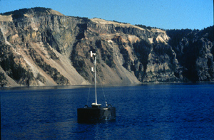
| Fig. 3. Crater Lake meteorological station, with 200-300 m high caldera walls in the background |
Most water enters the lake by direct deposition of snow and leaves by evaporation and seepage. The lake has extremely low nutrient inputs and organic production. As a consequence, it is also one of the clearest lakes in the world. (Secchi disk readings are typically greater than 30 m; 1% light depth is 90-100 m). Primary production in the lake is limited by nitrogen, with a nutricline present below 250 m. Maximum chlorophyll concentrations occur at 100-120m, while maximum primary production occurs between 40 and 80m.
Most phytoplankton and zooplankton species live between 80 and 200 m. Although there are no truly indigenous fish here, the lake was stocked annually with Kokanee salmon and brown trout from the late 1800’s to the mid-1940’s. The fish have since become an integral part of the lake’s ecosystem.
Research Efforts – Physical Limnology
|
|
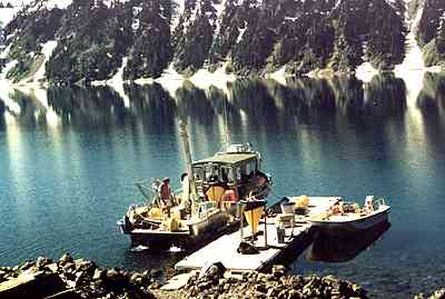
|
Fig. 5. Retrieving data and samples from the mooring. |
In situ observations of meteorological conditions on the lake surface and caldera rim as well as full water column temperature recorders have been established, maintained, and integrated into the ongoing Park research and monitoring program in cooperation with Park resource management. These datasets provide the critical input to models of lake physics and water level. These observations are supported by a series of limnological measurements that directly evaluate the vertical mixing and deep lake respiration rates. These rates have been coupled to a simple model of organic matter production, particle settling, and nutrient regeneration that demonstrate significant complexity in the way lake physics might control biological production.
 |
|
Fig. 6. View across lake from caldera rim. |
The in situ thermistor observations have allowed us to demonstrate dramatic vertical mixing ‘events’ in the Lake which ventilate the bottom of the deepest basins and force nitrate up towards the euphotic zone. Initial interpretation of these data suggested the possibility of thermobaric instabilities such as operate within Lake Baikal. Our models have demonstrated that these vertical mixing events could not be one-dimensional; a 3 dimensional numerical model is under investigation. Preliminary results show the 3-d model is able to reproduce the kinds of deep water exchanges we have observed. The parameterization of lake surface heat and water fluxes have been directly tested by our ability to integrate observed temperature and salinity changes from the thermistor and CTDT datasets. These validate the forcing we have developed for the lake and tell us a great deal about how mixing occurs within the upper 200 meters of the water column.
Results from a regional climate model (S. Hostetler, USGS) have been obtained for a location close to Crater Lake. These provide surface forcing conditions (winds, heat and hydrologic fluxes) for application to the lake circulation and hydrologic models. Two multi-year data sets have been selected, one corresponding to contemporary climatic conditions and the other to a 2XCO2 scenario. The data are presently being validated against actual observations in order to correct for discrepancies in location between the regional climate model and Crater Lake.
Motivation for Study
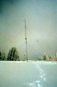 |
|
Fig. 4. Winter photo of the caldera rim meteorological station. |
Crater Lake has been of interest to scientists for the better part of a century. In 1982, however, Congress authorized a long-term, multi-disciplinary study of the lake in order to assess the water quality of the lake (and, in particular, to examine whether or not there was systematic degradation of water clarity). In the mid-1980’s, another furor arose over possible impacts of geothermal energy exploitation just outside the park boundary. Over the past decade or so, the focus has shifted to evaluation of the impact of climate variability and climate change on the lake. Among the goals of these programs, have been the development of: (a) an understanding of lake components and processes; (b) a ongoing observational program for monitoring changes; (c) models for predicting the potential impacts of future climate change on the lake.
Early studies of the lake were focused on biological processes and indicators. By the early 1990’s, however, it became clear that the relationships between climate and the lake ecosystem were dynamic and complex. Climate plays an important role in the performance of the lake by affecting temperature, mixing and transport, underwater light regime, water volume, nutrient inputs, and fish habitat. In order to better assess and quantify the connections between climate and the ecosystem, meteorological stations were set up on the lake and up on the caldera rim (Fig. 3 and 4) in 1992-93.
In addition, a long-term mooring, complete with an array of thermistors (to measure the lake temperature structure year-round, providing information about lake mixing dynamics) and sediment traps, was also established next to the lake met station.
Other pages in this section
*** previous title *** --- *** next title ***