Hydrology of Crater, East and Davis Lakes, Oregon by Kenneth N. Phillips
INTRODUCTION
LOCATION AND BRIEF DESCRIPTION OF THE STUDY AREAS
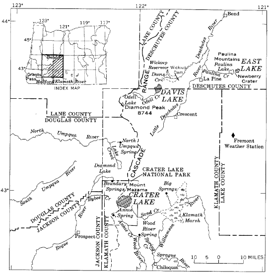
The three small study areas are situated. in the southwest quarter of Oregon (fig. 1). Crater Lake lies in a caldera at the summit of the Cascade Range, 65 miles north of the California-Oregon State line and 120 miles inland from the Pacific Ocean. East Lake lies 70 miles northeast, and Davis Lake 50 miles north, from Crater Lake. The three lakes are not subject to overflow, but do lose water by leakage.
The lakes lie in volcanic terranes that have been formed or significantly modified by volcanic activity in Holocene time. Crater Lake occupies the caldera of Mount Mazama, East Lake lies in the somewhat similar Newberry Crater, and Davis Lake is an impoundment on Odell Creek, formed by a Holocene permeable lava flow that dammed the creek channel. The topographic basins tributary to the lakes are small. However, because of the permeable nature of the volcanic soils and rock, some ground water may be transferred across topographic divides, and hence the contributory areas may be somewhat different from the topographic basins.
The lakes lie at moderately high altitudes, either on or adjacent to higher mountains. ‘Crater Lake, at 6,175 feet on the crest of the Cascade Range, and East Lake, at 6,375 feet in Newberry Crater of the Paulina Mountains, are similar in altitude but somewhat different in topographic environment. Davis Lake, at 4,390 feet, lies on an extensive lava plain from which many Holocene volcanic cones rise to altitudes of more than 6,000 feet.
 |
| FIGURE 1.-Location of lakes discussed. |
Weather records are relatively few in the sparsely populated mountain areas from which most of the runoff is derived. The mountains profoundly affect the climate of the area. The prevailing westerly winds carry masses of marine air from the Pacific Ocean across the region, especially in the period from November to March. Precipitation in that period, chiefly as snowfall, is heavy near the summits and on the windward slopes of the mountain barriers, but is considerably less at lower altitudes and on the leeward (east) side of ‘the Cascade Range.
The average annual precipitation in the region ranges from about 70 inches along the crest of the Cascade Range to about 20 inches on the plateau about 20 miles east of the range. It may vary greatly in short distances because of changes in altitude or topographic orientation with respect to prevailing winds.
In most of the region, the period June to September is dry, with warm days and cool nights. The warmest summer weather occurs in basins at the lower altitudes (4,100 ft), but because such basins have poor air drainage, freezing occurs there in all seasons.
Small thermal springs and seeps occur near the shore of East Lake. Similar springs may enter Crater Lake below the waterline. Such springs may provide a significant part of the dissolved-solids load in each of these lakes.
‘The water levels of the lakes respond to variations in the annual and long-term water supply and water loss. Typically, the peak of the annual cycle occurs in the spring season, near the end of the period of greatest precipitation and runoff, and is followed by a recession during the dry, warm summer months to an annual minimum in the late summer or early autumn. In periods of greater than ‘average precipitation and runoff, the lakes gradually rise until the combined evaporation from their increased area and leakage at the higher level offset their annual supply; in protracted periods of dryness, the water levels fall until a balance is reached.
The works of man, specifically the storage, use, and diversion of water, have not affected the lakes. Their changes in levels are indices of the balance between supply (precipitation and runoff) and loss (evaporation and seepage). All the lakes studied were at low levels in the 1930’s and 1940’s, after a series of dry years; all were at high levels in 1957 and 1958, after a series of wet years.
***previous*** — ***next***

