Geological History of Crater Lake
The Mazamas held a meeting in August, 1896, at Crater Lake in connection with the Crater Lake clubs of Medford, Ashland, and Klamath Falls, of the same State. Recognizing that the high mountain which once occupied the place of the lake was nameless, they christened it, with appropriate ceremonies, Mount Mazama. The rim of the lake is a remnant of Mount Mazama, but when the name is used in this paper reference is intended more especially to that part which has disappeared.

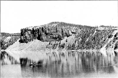
The inner slope of the rim, so well in view from Victor Rock, although precipitous, is not a continuous cliff. It is made up of many cliffs, whose horizontal extent is generally much greater than the vertical. The cliffs are in ledges, and sometimes the whole slope from crest to shore is one great cliff, not absolutely vertical, it is true, but yet at so high an angle as to make it far beyond the possibility of climbing. Dutton Cliff on the southern and Llao Rock on the northern borders of the lake are the greatest cliffs of the rim. Besides cliffs, the other elements of the inner slope are forests and talus, and these make it possible at a few points to approach the lake, not with great ease, but yet, care being taken, with little danger. Southwest of the lake the inner slope, clearly seen from Victor Rock, is pretty well wooded, and from near the end of the road, just east of Victor Rock, a steep trail descends to the water. Where fresh talus slopes prevail there are no trees, and the loose material maintains the steepest slope possible without sliding. Such slopes are well displayed along the western shore opposite the island and near the northeast corner of the lake under the Palisades, illustrated in figure 11. At this point the rim is only 575 feet high, and a long slide, called from its shape the Wineglass, reaches from crest to shore.

