Social Impacts of Design Alternatives, Crater Lake National Park
RIM VILLAGE
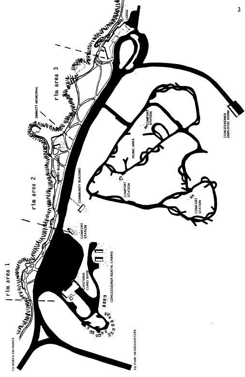
We observed behavior at Rim Village during the summers of 1977 and 1978. Rim Village (Fig. 1) is the center of visitor activity in the park. Physical structure was defined as the existing design of the area the most prominent features are three parking areas, three viewing areas along the caldera rim, and a large cafeteria building. The following description will be more clear if the reader refers to the map in Figure 1.
1 The logic of the design-behavior-experience argument is presented in more detail in pages 3-8 of “Experimental Effects of Design on Behavior in a Natural Resource Setting” (Shelby and Wolf 1980).
Figure 1. Layout and Facilities at Rim Village, Summer 1977.
People enter Rim Village by car from the west. The first opportunity to stop is the rectangular parking area north of the cafeteria building, which resembles the lot of a large supermarket and has spaces for 159 cars. The road proceeds along the north edge of the cafeteria lot to the center parking area, which has head-in parking on both sides of the road. This long and narrow lot appears smaller than the cafeteria lot, although it has spaces for 178 cars. At the end of the center lot is the 67-car parking area for the lodge, which has overnight accommodations.
Rim Village offers approximately one-quarter mile of viewing area along the caldera rim. A low stone wall and paved walkway follow the rim, and cross cutting walks connect the rim to the parking lots. We divided the viewing area into three sections, based on geographic location and physical structure.
Adjacent to the cafeteria parking lot, rim area 1 is long, straight, quite narrow (approximately 200 yds. x 15-30 yds.), and sparsely vegetated. Standing at the stone wall along the rim, a visitor is essentially right next to the road and the cafeteria lot.
Rim area 2, adjacent to the west half of the center parking lot, is slightly longer and somewhat wider than area 1 (approximately 275 yds. x 30-75 yds.). The wall and walkway wind along the rim, providing more varied spaces with large grassy spots and more trees. This area also contains the Exhibit Building and the Sinnott Memorial, which house the major interpretive facilities at Rim Village. On a lower plane, Sinnott Memorial is visually separated from the main area.
Rim area 3 is similar to area 2 except that it contains no buildings. The vegetation and walkways are varied, and a person standing at the rim is well removed from–although still in sight of–the road and parking lot.
The cafeteria building is a large stone and wood structure. It is a dominant feature upon entering the cafeteria lot, and it contains a curio shop, snack bar, small convenience grocery, cafeteria, and restaurant.
Data were first collected during a “base line” period in the summer of 1977. Analysis of these data and proposed redevelopment plans (both to be discussed later) suggested that it would be useful to know the effects of closing the cafeteria lot. This manipulation was accomplished in the summer of 1978, resulting in an “experimental” data collection period.
Data collection involved car counts in parking lots and observations of where people went and how they spent their time at Rim Village. Parking lot data were collected by simply walking through the lots and counting the number of cars in each one to determine the percent of spaces occupied. This was done 37 times during the study period, with times randomly distributed throughout the day. Counts were performed every hour during the experimental period (n=10).
Time distribution data were collected by randomly selecting cars as they entered Rim Village and then following the occupants as they visited rim areas 1, 2, 3, and/or the cafeteria.2 Data included the order in which areas were
2 During the base line period people were observed for their entire stay at Rim Village. Because this was too time-consuming and would have resulted in a small sample size for the shorter experimental period, we observed people only as they visited their first three areas; if by that time they had not left Rim Village, observation was terminated. To make them comparable, base line data were re-computed to reflect just the first three areas visited; this resulted in only minor changes.
visited and the time spent in each one. Each observation represented a group because individuals arriving together essentially stayed together. There were 49 groups observed during the base line period and 36 observed during the experimental closure.
FINDINGS OF THE EXPERIMENT
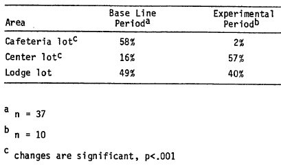
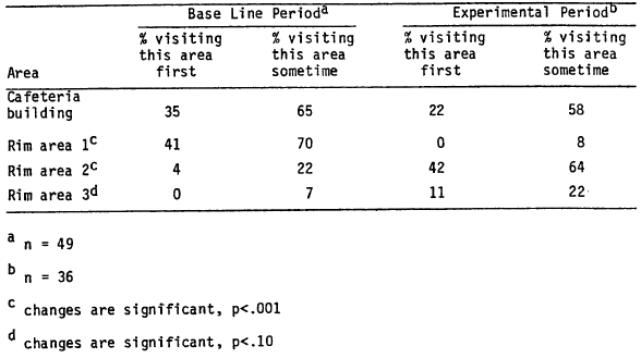
During the base line period, people were more likely to park in the cafeteria lot. On the average, 58% of the spaces were occupied between 8:00 a.m. and 7:00 p.m., while only 16% of the spaces in the center lot were filled (see Table 1). Use was concentrated in the cafeteria building and rim area 1 (see Table 2). Thirty-five percent of the visitors went to the cafeteria first, and 41% went first to rim area 1. About two-thirds visited both areas sometime during their stay. Only 22% went to rim area 2, and only 7% visited rim area 3.
Under normal circumstances, then, the average visitor to Rim Village arrives by car, parks in the cafeteria lot, and heads for the cafeteria or rim area 1, visiting both before leaving. The result is a north-south use pattern across the cafeteria lot. Most visitors never get to the other rim areas or the interpretive facilities (located in rim area 2).
When the cafeteria lot was closed during the experimental period, behavior changed dramatically. The obvious difference was that parking shifted from the cafeteria lot to the center lot, resulting in a 57% occupancy rate in the center area (see Table 1). There was no significant change in the use of the lodge lot.
The use of the cafeteria building was not significantly different, although the percentage of visitors who went there first and at some time decreased slightly (see Table 2). There were major changes in the use of rim areas 1 and 2. No one visited area 1 first and only 8% went there at all. The proportion of visitors who went first to area 2 increased from 4% to 42%, and 64% went there at some time. The use of rim area 3 increased slightly, but the difference was not significant.
Table 1. Average occupancy of Rim Village parking areas.
Table 2. Distribution of Use at Rim Village.
During the experimental period, then, the physical structure of Rim Village was changed by closing the cafeteria lot. People arrived and parked in the center lot, and they were most likely to visit rim area 2 first. The cafeteria was still a major attraction, but few used rim area 1 and the use of area 2 almost tripled, resulting in an east-west use pattern. The proportion of visitors using the interpretive facilities more than doubled (from 17% to 38%; p<.02).
IMPLICATIONS FOR MANAGEMENT
The concentration of use reflected in base line data suggested that some kind of structure was shaping user behavior. The experimental manipulation of physical structure produced a significant change, so this was a major determinant. It is important to note that other kinds of structure may also enter in. For example, the cafeteria building continued to attract visitors. This may be due in part to its prominent physical structure, but social structure (e.g., people look for a place to eat at mid-day) or the structure of past experience (e.g., people associate curio shopping with national parks) may also be important. Future studies could investigate the effects of these other kinds of structure.
It is reasonable to assume that the different behaviors during base line and experimental periods produced different visitor experiences. In the experiment, people visited a more spacious natural area with heavier vegetation. The walkways along the rim were longer and more varied, and users were further removed from the road and parking area. They were also more likely to visit the interpretive facilities. These certainly sound like different “experiences,” although this variable is difficult to measure directly.
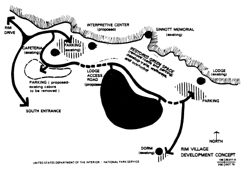
The issue of physical structure is particularly important because the Park Service intends to redevelop Rim Village. The plan is to remove some parking from the immediate rim area, replacing it with a lot south of the cafeteria where the “concessioner rental cabins” are now located (see Figure 2). The center parking lot would be converted to a “greenspace” or pedestrian mall. Base line data indicate that this scenario would further concentrate use in the vicinity of the cafeteria and rim area 1, leaving the new pedestrian mall unused (as the center lot and rim areas 2 and 3 are now).
Some Design Alternatives for Rim Village
The following discussion is intended to help in re-thinking the development plans for Rim Village. It reflects the information we have been able to collect in our own work and talking with managers, but it isn’t exhaustive. There may be other objectives or constraints that we haven’t considered. The discussion is easier to follow with a Rim Village map (Figure 1, Figure 2, or both) in front of you.
Specifically, there appear to be three major objectives for re-development in this area:
1) Decrease the concentration of use and congestion in the cafeteria lot-rim area 1 complex.
2) Eliminate the need for visitors to cross a major vehicle thoroughfare when walking between the cafeteria building and the rim.
3) Encourage use of interpretive facilities, as parking in the center lot did during the experiment.
The two major constraints (aside from money, manpower, etc.) appear to be:
1) Minimize environmental change
2) Provide for snow removal and winter use
Figure 2. Proposed changes at Rim Village.
There seem to be four major alternatives to accomplish these objectives.
1) Restore center lot to greenspace, add parking south of cafeteria building (cabins to be removed), and route lodge access road south of cafeteria. This is the “development concept” outlined in the October 1976 D.S.C. and shown in Figure 2.
2) Restore cafeteria lot to greenspace, add parking east of cafeteria and south of existing restroom building, route access road south of cafeteria.
3) Restore cafeteria lot to greenspace, add parking east of cafeteria and south of existing restroom building, route access from Munson Valley up past employee dorm. Traffic could exit by returning over the same route or via one-way road south of cafeteria.
4) Restore cafeteria lot to greenspace, add parking south of cafeteria building (cabins to be removed), route access south of cafeteria.
The alternatives are evaluated using objectives and constraints as evaluative criteria in Table 3. Alternative 1, restoring the center lot and shifting parking south of the cafeteria, would increase congestion around the cafeteria complex. Pedestrians would cross somewhat less traffic because some parking would occur south of the cafeteria, but the interpretive facility would be “off the beaten track,” as it is now. Placing the proposed visitor center on the east end of rim area 2 would probably help but not completely solve this problem. This alternative would meet both constraints because there would be no new impacted areas and the cafeteria lot could be used in winter as it is now.
Alternative 2, restoring the cafeteria lot and shifting parking to the area east of the cafeteria, would decrease congestion by moving parked cars out of the pedestrian route which goes from the cafeteria to the rim. Pedestrians would not have to cross traffic, and the parking would be on the more east-west line from the cafeteria to rim area 2 and the interpretive facilities, encouraging use of those areas. The parking area east of the cafeteria would create some new impacts, but it appears that this area was already impacted when the old campground was built originally. The winter use issue is unclear; some people contend that access south of the lodge and use of this parking area would be a problem because snow drifts into this area. More definitive information about snow depths may be needed.
Table 3. Evaluating Alternatives for Rim Village Redevelopment.
Alternative 3 is the same as alternative 2 except that a new access road would connect the highway up from park headquarters to the road past the concessioner dorm. Traffic could go both ways or one-way with the exit road running south of the cafeteria. This would decrease congestion more than other alternatives because traffic would flow one way and people would tend to park in the center lot, the first place they come to. Pedestrians wouldn’t have to cross traffic and the interpretive building would be the first building seen from the center parking area, thus encouraging its use more than with other alternatives. The major drawback is the expense and environmental impact of the new road, although the distance separating the two existing roads is very small (walk part way up Mt. Garfield and take a look). The winter use issue needs exploration, but presumably the new road would be no harder to maintain than the current road, especially if it could handle two-way traffic during the winter.
Alternative 4, restoring the cafeteria lot and adding parking south of the cafeteria, would only partially decrease congestion in the cafeteria complex. People would park in the new lot (rather than the center lot) because it would be most prominent, but at least pedestrians would not have to cross traffic. Visitors would wind up in the cafeteria building first, but they would still walk out to the rim, and they might get to the new visitor center if it were close enough and easily visible. This design would not impact any new areas and would provide for winter use if snow removal south of the cafeteria is feasible (as per discussion of alternative 2).
OTHER FINDINGS AT RIM VILLAGE
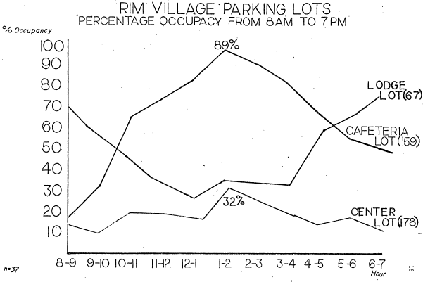
Observations at Rim Village turned up several other findings. Average occupancy rates for the three parking areas during different times of the day are shown in Figure 3. The peak use times for the cafeteria and lodge lots reflected the activities there; the cafeteria lot filled up during the middle of the day, whereas the lodge lot was used at night. The center lot was generally used as an “overflow” lot; cars appeared in the west end during midday when the cafeteria lot filled and in the east end at night when the lodge was used.
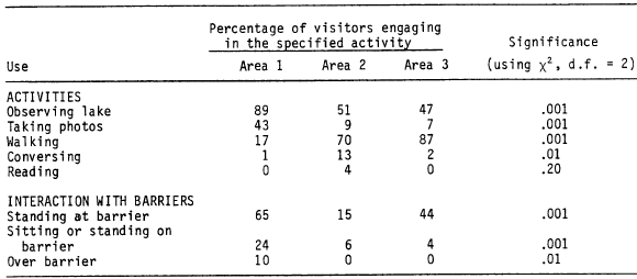
Visitor activities in the three rim areas are shown in Table 4. Area 1 essentially was used for observing and photographing, whereas walking was the most common activity in areas 2 and 3. Almost all the visitors in area 1 spent some time observing the lake, compared to about half the people in other areas. Very little conversing or reading occurred in any area. Total time spent at rim areas 1, 2, and 3 averaged 10, 23, and 7 minutes, respectively.
People used the stone barrier differently in the areas. A higher percentage stood at, stood or sat on, or crossed over the barrier in area 1. The narrower space in area 1, as well as the predominance of observing and picture-taking, probably account for people being at or on the barrier. People also crossed over the barrier in this area to feed the ground squirrels or see “better” (the wall in other areas was close enough to the edge that crossing over offered no advantage).
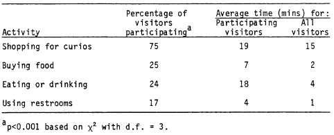
Within the cafeteria complex, shopping for curios was the predominant activity (see Table 5). Seventy-five percent of the people shopped, whereas 25 percent or less bought food, ate or drank, or used the restrooms. Time spent in the cafeteria averaged 23 minutes for all visitors.
Figure 3. Rim villager parking lots.
Table 4. Visitor Uses of Rim Areas.
Table 5. Visitor Activities Within Cafeteria Building.
Other pages in this section
*** previous title *** --- *** next title ***
