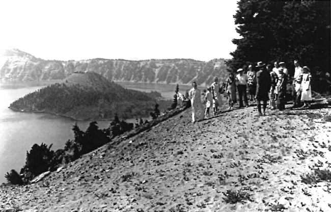
Construction of a new trail to the top of Wizard Island resulted from a visit by NPS senior park naturalist Ansel F. Hall, who had come to the park in July 1931 from his duty station in Berkeley, California. Hall and an assistant used surveying equipment and stakes to lay out a trail on an eight percent grade, intending it to replace an earlier, but steeper, route. This had a direct connection to the naturalists starting a ranger-led boat tour of Crater Lake that summer, something which included a hike to the top of Wizard Island.85 They built what Hall called the “spiral return trail” without clearance from Sager or the other landscape architects, but with the consent of Superintendent Solinsky, who evidently thought its attributes outweighed being more readily seen from the rim. At 30 inches wide, the drifting of cinders quickly began to obscure the line even during the first season. Put on the defensive, Hall and other naturalists pointed to its value in conducting guided walks on the island; not only were marked changes in flora evident on the cinder cone depending upon aspect, but a circular route made tree patterns and geological formations more striking.86
 |
| A ranger and visitors at Merriam Point, 1936. Part of the “spiral return trail” is visible in the distance. Photo by George Grant, NPS Historic Photograph Collection. |
Hall also marked a trail along the shoreline to what was later called Fumerole Bay, though the route went from the summit crater down to the water along the island’s north side. It still lacked a connection with the boat landing at Governors Bay, something recommended in a report written the following summer by Worth Ryder, an art professor from the University of California. At the behest of cooperating scientists who served as volunteer advisors to the NPS, Ryder made a series of suggestions as part of studying the park’s aesthetic qualities so that ways could be found for visitors to better appreciate them. His report of August 1932 mentioned new trails in several places, marking the first time that anyone outside the NPS provided suggestions about what additional routes might enhance the experience of visitors.87
Among Ryder’s recommendations was for building a trail from Cleetwood Cove to the rim above it, something that he believed could make possible a combination boat trip and road tour. The NPS took no action on that idea, nor did it act on his suggestion to construct a trail from Garfield Peak to Sun Notch. Ryder may have had some influence in urging that Rim Drive be kept at least 200 yards away from the rim at Sun Notch, a site that he considered the most important viewpoint in the park.88 In emphasizing that great care had to be taken in designing a pedestrian route along that portion of the rim, he went so far to urge that every foot of potential trail be studied prior to construction since Sun Notch could be made into “the most delightful scenic wonder of the entire Park.”89
No such study followed from Ryder’s recommendation, though a group of faculty members from the University of Oregon took up the question of how visitors could best appreciate nature at Crater Lake the following year. This eventually resulted in a collection of short reports and observations made throughout the park over the course of several summers and included some references to existing trails, insofar as they might contribute to visitor understanding of scenic features.90 Unlike Ryder, the UO authors did not suggest where to build new trails or which of the existing routes to reconstruct. For the most part, trail projects continued to emerge on an ad hoc basis through the superintendent or one of his key subordinates, but on the whole represented only a small fraction of the undertakings aimed at improving park infrastructure during the decade of the 1930s.

