Nevertheless, trails could enhance both the park’s recreational potential and factor into larger operational goals like suppressing wildfires in the backcountry. As an example, Chief Ranger Bill Godfrey reported in July 1930 that a NPS crew built a trail from the base of Crater Peak to its summit. He described it as being of a standard width and holding a grade of roughly 15 percent in order to reach the top, which Godfrey saw as valuable as an observation point during fire season.91 The new trail climbed the peak’s north side by heading west with an elongated curve so that the summit could be reached on a steady grade without switchbacks. Godfrey made no reference to any earlier trail, though he mentioned following “an old wagon road” to reach the base of Crater Peak; most likely the route built during Sparrow’s tenure as superintendent.92
Construction of the trail to Crater Peak came in conjunction with building a network of access roads to aid with fire suppression. In this case, the “motorway” or “truck trail” started from the Rim Road near Tututni Pass and was intended to allow park crews to reach places where lightning strikes had caused fires. Limited to administrative use for vehicular travel, these roads were routed in order to minimize the time needed for park crews to reach smokes or wildfires on foot. They could also form part of the hiking or horseback route to a backcountry destination, as at Crater Peak. Although not intended as trails, some of the motorways at Crater Lake received use by visitors in the absence of routes engineered and built for pedestrians.
Motorway construction began in 1930 after location work was initiated with compass surveys, then followed by field drawings and stakes that set road locations.93 This effort took place at Crater Lake and other national park units once the NPS received dedicated funding for fire suppression activities in 1929. It eventually resulted in 130 miles of motorways in the park (a figure which almost doubled that of paved highways at Crater Lake) with grades ranging from flat to ten percent. Built with a bulldozer, the operators simply scraped litter down to mineral soil and pushed material to one side. This created a swath 12 feet wide after some clearing of trees, but inadequate provision for drainage and lack of maintenance meant that sporadic work was needed to keep the motorways serviceable for NPS use.94
The motorway toward Crater Peak included some new construction where Godfrey and others thought the “wagon road” to be problematic or too steep. It more or less followed the older route with some reconstruction to the base of Crater Peak, along the ridge separating the Annie Creek and Sun Creek drainages.95
 |
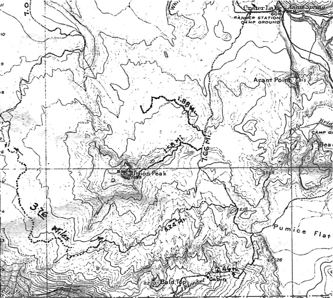
| Map showing several motorways in the southwest quadrant of Crater Lake National Park, author’s files. |
Hikers and equestrians traversed only that initial portion of 1.5 miles in order to reach the trail leading to the summit, though the motorway was extended southward to the boundary over the next three summers. This came in accordance with Godfrey’s desire to provide administrative access to the park’s southeast corner, where it could be linked with other motorways.
Godfrey also reported on reconstruction of the Union Peak “Trail” in the summer of 1930. He made a distinction between the trail (for the most part a road since its initial construction in 1918) and a motorway. This was due to the former remaining open to vehicles driven by visitors, even though down trees had prevented such use for several years prior to 1930. With rocks and stumps removed, in addition to grading done to fill in high centers, the “trail” was reopened that summer from a turnoff located along the West Entrance Road to the base of Union Peak. It came with some realignment of the older route, including the addition of more than a half mile from the end of the “trail.” The extension was to create a linkage, if only for the NPS, with a new motorway built to cross the Cascade Divide from the South Entrance Road. This one traversed Pumice Flat on its way toward Union Peak and could form something of a loop, taking in several miles of highway to complete the circuit.96

