
With scarcely enough money to open the Crater Wall Trail (in addition to the NPS maintaining the routes to Garfield Peak, Discovery Point, and the Watchman), the list of existing pedestrian routes had not changed during the decade of the 1940s.137 The possibility of increased funding for trail maintenance led to some estimates approved by Leavitt, which he forwarded to the regional office in San Francisco in the late summer of 1949. Based on work by one of the rangers, these estimates included some comment on each of the 18 trails, mostly to justify re-grading some of the routes while oiling was proposed for others.138
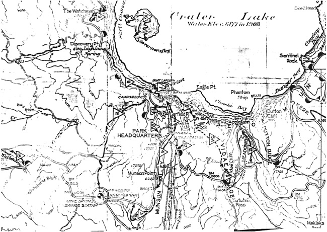 |
| Master Plan section showing a portion of the park’s trails, 1950, author’s files. Note the bridle trails (numbers 3, 4, 17, 19, and 20, as (5A) between Garfield Peak and Vidae Falls, Sparrow’s route up Sun Valley (12) is also depicted. |
Just as before, what funding for trails that could be obtained went to the most popular routes, so that some of the remainder fell prey to neglect. This seems to be the case for the bridle paths, except where enough intermittent foot traffic could sustain a trail, such as the one between Park Headquarters and the Rim Campground. Short trails along Lost Creek and into Llaos Hallway likewise faded, as did the partially constructed route near Vidae Falls.139 The route connecting Sun Notch with the old Rim Road had also become faint for the most part, though a piece of it disintegrated into desire lines once visitors passed through a small cut bank located just a short distance from the parking area on Rim Drive.140