Postcards from the Rim
Herald and News
Klamath Falls, Oregon
April 26, 2004
By LEE JUILLERAT
New guide book by Crater Lake National Park historian provides information about the history of Rim Drive with some neat twists.
It’s not living on the edge, but traveling around the rim at Crater Lake National Park is always an experience.
Rim Drive is a 33-mile road that loops around the lake. Along its circuit it provides many stunning lake views, forested picnic areas and access to trails.
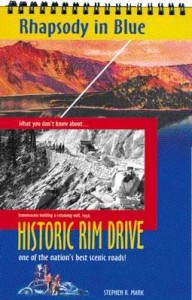
Driving the road will take on new meaning this summer thanks to a new publication, “Rhapsody in Blue: Historic Rim Drive,” by park historian Stephen Mark with a funky, retro graphic design by Mary Williams Hyde.
Although “Rhapsody” is packed with information about the history of the road, Mark’s publication is more than a book. Its spiral binding means that its pages can be easily flipped so that its can be truly used as a guide when driving around the rim. In another neat twist, it also includes a dozen detachable postcards featuring historic photos taken along Rim Drive.
Mark, who is in his 17th year at the park, is possibly the singer person with best understanding of the park’s and its seldom-seen secret places. Among his suggested stops are several not typically visited.
On Segment 7, from Cloudcap to Kerr Notch, Mark provides information about Victor View, named in 1945 to honor Frances Fuller Victor, Oregon’s first historian. As Mark taught me several years ago, an short but unmaintained trail goes through a grove of trees then drops steeply along a slippery, pumice slope to an overlook at Sentinel Rock. The view is stupendous, unlike any other in the park. It’s my personal favorite lake viewpoint.
Through the use of a generous collection of historic photos, the booklet makes it easy to gain a better appreciation of the work involved in building what is now Rim Drive.
Among the photos is one of James A. Garfield, then the Secretary of the Interior, on a stagecoach in 1907. It was later than summer that the first car reached the rim. Other shots show horse teams plowing and harrowing the rough grading on the old Rim Road, crews with shovels trying to clear the road of snow in 1917 and side-by-side Model A type vehicles on the unpaved road in 1919.
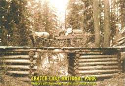
Several of the postcards are equally impressive. One shows a horse-drawn wagon crossing an old wooden bridge before 1920, another features a skier atop the snow-covered cafeteria in 1947 and, most eye-boggling, another shows a crew building a retaining wall at Scott Bluff in 1934.
“Rim Drive is a classic example of a circuit road meant to present nature to visitors, but one carefully designed to blend with the magnificent setting of Crater Lake and dramatic landscapes of subalpine forests, open pumice fields, and jagged peaks,” writes Mark.
“Rhapsody” is a nice companion to Mark’s earlier trail guide, “Park Headquarters Historic Walking Tour,” which was also published by the Crater Lake Natural History Association. Copies are currently available only at the park’s visitor centers.
BACKGROUND: The reverse of each page features a map of the rim section featured and where that section is located on the lake’s edge. Maps are by Phil Kelley.
 The guide is packed with information about the history of the road, but it is, more than a book. Its spiral binding means that its pages can be easily flipped so that its can be truly used as a guide when driving around the rim. It also has a very retro design by Mary Williams Hyde. The guide is packed with information about the history of the road, but it is, more than a book. Its spiral binding means that its pages can be easily flipped so that its can be truly used as a guide when driving around the rim. It also has a very retro design by Mary Williams Hyde. |
Other pages in this section


