National Park Service Cultural Landscapes Inventory: The Watchman, Crater Lake National Park, 2001
Physical History
1930-1939
Further site analysis was essential in establishing the new observation station on Watchman Peak. Consideration was given to aesthetics and programmatic needs. The new trail and building were to embody Naturalistic and Rustic architectural principals of design, while also serving as a fire watch/educational opportunity for park visitors. The General Development Plan influenced the construction of the Watchman’s trail and observation station. The cohesive plan was conceived to incorporate these design theories at Crater Lake. The General Development Plan was considered “essential in the late 1920s and was viewed as a way to manage park resources as a whole. When Stephen T. Mather became director of the NPS in 1917, he helped formulate the Service’s policy statement of that year to the effect that all roads, trails, buildings, and other improvements be carried out with their ultimate harmony with the landscape in mind” (Greene, 1984, 185-187).
Rustic architecture and Naturalistic landscape architecture espoused a harmonious relationship between structures and their natural surroundings. This concept was highly influential in the design of the Watchman Observation Station and Watchman Trail. This was achieved primarily by using “natural” materials including native wood and stone in an effort to seamlessly integrate structures with their surroundings. Specific aspects of the style included use of native materials, simplicity in design, avoidance of overly perfect construction lines, use of exterior colors such as brown and gray to blend with the settings, and a general look as if the structure was built by pioneer craftsmen. Structures were to be subordinate to their surrounding environment, creating the overall feeling that the structure was less important than its setting (Greene 1984, 185-6). As site planning for the Watchman Observation Station continued in the early 1930s, Thomas C. Vint, Chief NPS Landscape Architect, espoused this design philosophy saying: “all buildings on the Rim of Crater Lake should be very inconspicuous, in order that one viewing the crater from any point would not feel the presence of buildings. This is, of course, in accord with the principles of any landscape development in the National Parks” (Vint, 1930, n.p.). Additional programmatic elements included an outside stairway sited close to the terrace for visitor convenience and a platform surrounding the tower to allow “…better visibility…and…space for visitors” as well as a comfort station proposed to better accommodate the expected “great number of people” (Hall, 1930, n.p.). Construction was set to begin in 1931 with sketches provided by Charles E. Peterson in 1930 and working drawings by Francis G. Lange in 1931.
Construction and development projects at Crater Lake were put in jeopardy, however, in the early 1930s when budgetary constraints developed due to the Great Depression. Funding provided by the Hoover administration, however, infused the NPS with funding for additional day labor, allowing the Watchman project to proceed. By 1933, Watchman Observation Station was completed by government emergency public works funding designed to counter the effects of the depression. Without this federal funding made possible through the Emergency Conservation Work (ECW) and Public Works Administration (PWA), projects associated with the Crater Lake General Development and Master Plans would not have been completed. The 1933 construction season was the first at Crater Lake to be affected by such appropriations (Unrau, 1988, 479-83).
Watchman Trail Construction
Although funding was available and construction had commenced for the second version of the Watchman Trail, justification for its existence was noted in a report from Worth Ryder to John C. Merriam in 1932. Ryder vigorously defended trail construction stating: “I was told at the Park that little money will be given for trails because few people use the trails. It is more important to build trails for the few who have interest enough to use them than to build roads for the many. It is of little value to run thousands of people up to a scenic point and then hurry them past it to another point. Nature speaks only to one who has ears to listen and time to listen. People who will give time to receive impressions from nature will probably be uplifted spiritually by nature. Such people are worth our trouble…Personally I should not waste the taxpayers money on him who has neither interest nor courage enough to salute the dawn from the summit of the Watchman” (Ryder, 1932, n.p.).
Because of Ryder’s strong argument, and because the observation station required a trail in order to “get materials up for the construction of the Watchman Lookout Station”, the second version of the Watchman Trail was aligned in 1931. Considered temporary, this second alignment would be enhanced a year later upon completion of the Watchman Observation Station in 1932 (Sager, 1932, n.p.).
At a cost of $1,000, the third and final alignment of the Watchman Trail was completed in 1932. This iteration was approximately half a mile in length, five feet wide and aligned at a maximum 15% grade (Superintendent’s Annual Report, Crater Lake NP, 1932). Beginning at a point on the new Rim Drive (graded in 1931) on the northeast side of Watchman Peak, the final alignment began by following the old Rim Road on its north side. The trail then spurred from the old alignment with switchbacks and small retaining walls and “stone slabs for use as benches” along the trail. Once the trail was complete, it was oiled “to reduce dust”(Robertson, Final Completion Report on the Watchman Summit Trail Construction, 1932). Completed to the same standards of construction as the Garfield Peak trail (Garfield Peak standards included strong rock parapets constructed to “insure safety” and “natural rock” mortared together to “blend in with the rustic topography of the rim”(Green, 1984, 164)). Meticulous care was taken during construction by Chief Landscape Architect Merel Sager to ensure the trail’s naturalistic appearance. In the case of the Godfrey Glen Trail, constructed during the same time period, Sager was known to “admonished” the crew to make the trail seem natural by “roughening the edges of a fallen tree trunk, through which the path was cut, to simulate the appearance of a natural path that had occurred over time” (Larry V. Espey, recorded interview with Patricia Erigero, n.d.). It is evident that Sager took this kind of care during Watchman Trail construction.
Watchman Observation Station Construction
Watchman Observation Station was completed on time in 1931 at a cost of $5000 and was described as a “complex” building project in a 1932 NPS report. The Watchman Observation Station symbolized the dualistic approach of the NPS to conserve the park’s natural resources while also educating the park visitor about these resources (Greene, 1984, 250). Located on the west rim of the lake, the building was walled with massive stones to house the museum room focusing on the theme of fire prevention education. The first floor was the most accessible for the visiting public and therefore included a comfort station.
The building was four sided with its steel-framed second story resting only on a “portion of the irregularly-shaped first floor” and enclosed by a series of eight-foot plate glass windows for maximum visibility. The roof of the observation room and the catwalk around it were constructed with logs, enabling the tower to blend in remarkably well with the peak (Sager, A Summary of Construction During the Season of 1932). Other infrastructure components were integrated into the building including a 4000’ water supply line from Lightning Springs and telephone lines connecting Watchman Observation Station to the park system (Robertson, 1931). After completion of the observation station in 1932, it was noted by a fire control expert named J.D. Coffman that the structure was “the best fire lookout building in the United States” (Sager, 1932, n.p.).
Watchman Observation Station Opens
Six months prior to Watchman Observation Station’s opening, its mission at Crater Lake was clarified in a letter from D.S. Libby to John C. Thomas, a supervisor at Pacific Telephone and Telegraph Company. “We particularly ask that the title for this station be “Watchman Observation Station” rather than to call it a fire lookout because its equipment and purpose is twofold and under no condition do we intend to designate it simply as a fire lookout. The attendant in charge of the station is an individual prepared to explain the scientific features of Crater Lake as well as to locate fires”(Libbey, 1933, n.p.).
On July 27, 1933 Watchman Observation Station was opened to the public and was immediately popular. During its first month of operation, 1,036 park visitors came to the observation station either as individuals or as part of a tour, the most popular of which was the guided sunset tour, “A Pilgrimage to the Watchman.” A Ranger-Naturalist was placed in charge to meet the visitors at the base of Watchman Peak and conduct the party to the station to “view the sunset” and “the unusual shadows and lighting effects prevailing at that hour” (Demaray, 1933). Further refinement on interpretation occurred in the next summer with the addition of a script used by the Ranger-Naturalist to explain the surrounding topography. A document entitled Geology on Rim Caravan: Notes for Leaders of the Caravan explained in detail what the visitor was viewing. The following illustrates the level of detail of the interpretation program:
“Watchman Stop”
First good, general view of entire lake basin—point out general features. Good view of Klamath basin (a “graben”, or down-dropped area, with “horsts” or up-raised blocks, on either side), Mt. McLoughlin (Pitt is older name) and Mt. Shasta.” (Smith, 1934, n.p.).
Watchman Observation Station was also valuable as a fire lookout. Rangers stationed on lookout duty were in constant communication with each other by short wave radio and telephone. The observation station was part of a network of fire watches that served Crater Lake National Park and the national forests surrounding the park. The network provided “almost one hundred percent visibility of the forests in the Crater Lake region” (Greene, 1984, n.p.).
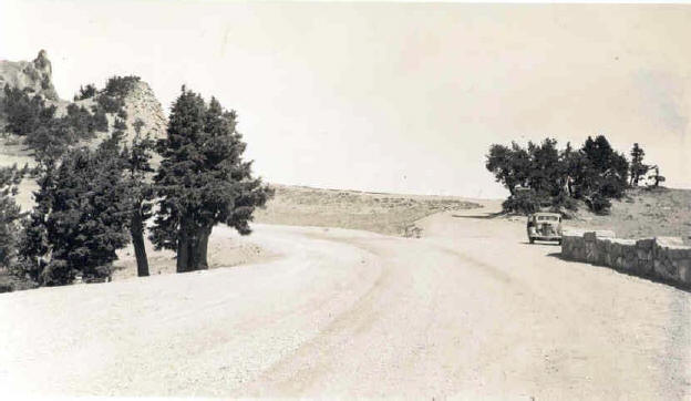 |
| Historic photograph showing parking lot located at Watchman Overlook c. 1934 (Photo by Lange, CRLA archives). |
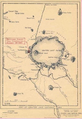 |
| Historic map showing that trail construction at Watchman Peak is complete, 1932 (CRLA archives). |
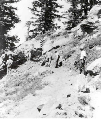 |
| Historic photograph of Discovery Point Trail construction in 1932 (CRLA archives). |
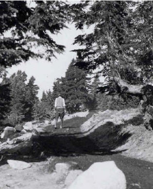 |
| Historic photograph showing Watchman Trail after it has been oiled to reduce dust, 1932 (CRLA archives). |
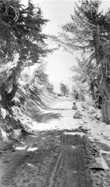 |
| Historic photograph showing Watchman Trail is lined with rock on the down slope side of the trail, 1932 (CRLA archives). |
Other pages in this section

