
Continued from Volume 17 page 2
Additions to the Flora
By James Kezer, Ranger-Naturalist
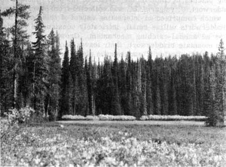
A bog in the vicinity of Crater Spring.
(CRATER LAKE NATIONAL PARK – 1951)
One of the exciting experiences of the 1951 season was the discovery of a large area of sphagnum bogs in the northwestern part of the park It is not surprising that ten plants previously unknown from the park were found in this new and distinctive kind of habitat.
On the evening of September 14, Lawrence Bisbee, Fred Larmie and I explored a remote and seldom visited region of the park south of Crater Spur Motorway in search of a pond that had been reported in 1937 by Dr. Applegate. About one-quarter mile south of the motorway spur we entered an extensive, beautiful, wet montane meadow that was characterized by boggy areas covered with sphagnum moss. Although exact measurements were not made, we estimated that the meadow extended over at least ten or fifteen acres.
To the northeast, it was bounded by a row of alpine firs below which was a hedge of willows that looked as though it had been planted and clipped. Growing abundantly in the sphagnum was a carnivorous plant, mountain bladderwort, Utricularia intermediaHayne, its yellow flowers forming patches of color on the surface of the bog. Another species of bladderwort, U. vulgaris, L., was collected from several small bog ponds which comprised an interesting aspect of this boggy meadow. The bladderworts utilize small, intricately constructed bladder-like traps as an animal-catching mechanism. Growing in the sphagnum with the mountain bladderwort, their leaves forming patches of red, were two other species of carnivorous plants, round-leaved sundew, Drosera rotundifolia L., (previously known in the park only from Copeland Meadow) and long-leaved sundew, D. longifolia L. The sundews have glandular hairs on their leaves which provide them with a flypaper-like secretion in which small animals become entrapped. In the ponds with the bladderwort was a pondweed, Potamogeton pusillus L., and in the nearby wet sphagnum were a few plants of the marsh cinquefoil, Comarum palustre L.
A number of days later, I returned to Crater Spring and hiked along the northern side of the creek toward the western boundary of the park. A very short distance from the spring I entered another boggy meadow that extended at least one-half mile along the creek. In nearly every respect it was similar to the sphagnum meadow that had been previously discovered; however, it contained a bog pond that differed considerably from those present in the meadow south of Crater Spur Motorway. This was a body of water about 120 feet in diameter, surrounded by a floating mat of vegetation which extended into the pond as its bottom. The mat of vegetation was so fragile that it would not support my weight and it made collecting in the pond extremely difficult. An abundant growth of sedges and aquatic plants protruded through the water’s surface, leaving only small patches of open water. Buckbean, Menyanthes trifoliata L., was growing in the sphagnum around the pond with marestail, Hippuris vulgaris L., and the floating pondweed, Potamogeton natans L., conspicuous in the water among the sedges. A small burr-reed Sparganium minimum Fries, was also growing in the pond. At the edge of the water, in the mud of the floating mat of vegetation, were a few clumps of stick-tight,Bidens cernua L.
It is highly probable that a more detailed exploration of these two areas will yield other plants that have not been reported from the park.
It should be emphasized that the areas in which these new plants were found represent a totally new habitat for the park. Sphagnum bogs were previously unreported within the boundaries of the park; furthermore, the park contains only one permanent pond (discussed elsewhere in this issue of Nature Notes) other than these Crater Creek bog ponds. There can be no doubt that these newly discovered bogs and ponds, with their distinctive plants and animals, add to the biological significance of this magnificent National Park.
The Rocks of Crater Lake
In order to understand the character of the rocks of Crater Lake National Park, it is necessary to have a general understanding of the major classes of rocks. According to their origin, all rocks can be placed in one of three groups: sedimentary, igneous, or metamorphic.
Most sedimentary rocks are composed of small particles of other primary rocks which have been transported and deposited in water. The common sedimentary rocks of this type are shale, sandstone, and conglomerate. Sedimentary rocks may also be formed from chemical precipitates of material that was dissolved in the water. Limestone is an example of this type of sedimentary rock.
Igneous rocks are formed by the solidification of molten rock, called magma. This magma originates far below the surface of the earth where the temperature is high enough to melt the rock.
Metamorphic rocks are formed when an existing rock is changed by heat, pressure, solutions, or a combination of these forces. For example, limestone is changed to marble, shale is changed to slate.
Because the rocks in Crater Lake National Park are igneous, a more detailed description of this type of rock is in order. In considering igneous rocks, a very important concept must be understood: the relationship between the rate of cooling of the magma and the resulting grain size. If the magma is cooled slowly, the constituent minerals have time to grow to large size; if the magma is cooled rapidly, more crystal nuclei form spontaneously and none can grow to large size. Extremely rapid cooling results in a non-crystalline rock, or glass called obsidian. The mineral crystals of an igneous rock may not be all of the same size. Because of some variation in the rate of cooling, the rock may consist of large crystals, called phenocrysts, embedded in a fine grained or glassy matrix called a groundmass. This rock, containing both large and small crystals, is called a porphyry.
There are two general classes of igneous rocks: intrusive or plutonic, and extrusive or volcanic. The intrusive rocks are those formed when the magma solidifies far below the surface of the earth. Because of the insulating properties of the overlying rock, the cooling is slow and the resulting rock is coarse grained. Granite is a common example of an intrusive igneous rock. Extrusive rocks are those formed when the magma, called lava in this case, is extruded to the surface of the earth. On the relatively cool surface the rock solidifies quite quickly and the resulting material is fine grained.
The shape of the topographic feature built up around the volcanic vent depends upon the physical characteristics of the rock that is extruded. If the extruded material consists of fragments, called pyroclastics, the resulting feature is called a pyroclastic cone. These cones are quite steep, but not very high because of the unconsolidated nature of the rocks. If the extruded material consists of lava flows, the resulting feature is called a shield volcano. The steepness of the slope depends upon the viscosity of the lava; the more viscous lavas pile up around the volcanic vent and produce a steeper slope than is produced by the more fluid lavas. A volcano composed of both pyroclastics and lava flows, roughly stratified, is called a stratovolcano.
There is a great variety of material ejected from volcanoes. The lava may flow from the crater in the summit or, more probably, from fissures in the sides. A volcano may erupt violently, throwing rock particles high into the air. This material may be fragments of solid rock torn from the sides of the vent or it may be clots of liquid rock or both. The size of these particles varies from masses weighing tons to fine dust. The largest are called blocks and the smaller particles are called, in order of decreasing size, cinders, ash, and dust. Volcanic bombs are rounded or twisted pieces of rock, formed from clots of molten rock hurled, spinning through the air.
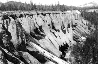
Crater Lake exists in the caldera caused by the collapse of the upper portion of a volcano. The present cliffs above the lake reveal an excellent cross-section of this volcano which has been named Mt. Mazama. Alternate layers of various types of rocks indicate that this was a stratovolcano.
Most of the rock in the vicinity of Crater Lake is porphyritic andesite, a volcanic rock intermediate between the acidic rocks containing much silica and alumina, and the basic rocks containing the ferro- magnesian minerals. Andesite is typically light gray to dark gray in color, sometimes almost black. Less abundant than the andesite is a siliceous rock that occurs in two forms. Dacite is a hard, dense, glassy, gray rock. Its glassy appearance distinguishes it from andesite and it frequently has a definite flow structure. This dacite may be called obsidian, but the presence of phenocrysts renders it a glass porphyry instead of a true obsidian. The other siliceous rock is pumice, a light weight, porous rock formed from liquid rock with a great quantity of finely dispersed gas bubbles. Most of the pumice is so light that it will float on water. Another rock, basalt, is found only at lower elevations in the park. Basalt is a dense, hard rock which is dark colored because of the predominance of ferro-magnesian minerals. Its source in this area was a system of small volcanoes on the lower slopes of Mt. Mazama.
In Crater Lake National Park there are many excellent opportunities to observe the structure of the rocks. In the cliffs above the lake an excellent cross-section of this volcano is presented. From the lake, the rough layering in the walls is quite apparent. The strata consist of dense flows of andesite, layers of pyroclastics, pumice, and glacial till. There are also a few flows of dacite, prominent among which are Llao Rock and Redcloud Cliff. Dikes are other features to be observed from the lake. A dike is created upon the solidification of magma squeezed into a crack in an older formation. Devil’s Backbone is the best example of a dike in this area.
The characteristics of a cinder cone and a block lava flow are best studied on Wizard Island. The main portion of the island is a cinder cone, simply an unconsolidated pile of cinders and ash. The base is a lava flow that is now almost completely covered by water. The west side of the island affords an excellent example of a block lava flow, whose angular fragments represent the solidified crust broken and pushed into its present form as viscous lava persisted in emerging from fissures in the sides of this volcano.
At lower elevations of the park, there are many spectacular gorges of which Llao’s Hallway on Whitehorse Creek is particularly fascinating. It is an extremely narrow, deep gorge with steep walls that are vertical or undercut in many places. The rock is a very thick deposit of partially consolidated pumice.
A very common feature of these river gorges is en erosional structure often called “pinnacles.” These structures occur in partially consolidated rock and are “fossil fumaroles,” columns in the rock hardened by rising gases.
The visitor at Crater Lake is afforded an excellent opportunity to study the structure of a volcano. From the Garfield Peak trail one can observe both the interior of Mt. Mazama and the exterior including a considerable portion of the High Cascades. From the lake trail and from the motor launch the interior of this volcano may be studied in detail. On Wizard Island, the volcano that grew in the caldera quite recently, the visitor can study the well-preserved cinder cone and the block lava flow. Nature has indeed been generous in providing us with this deep caldera whose high walls, not obscured by talus or vegetation, reveal the history of a great fire mountain.
The “Lost” Pond (Crater Lake National Park)
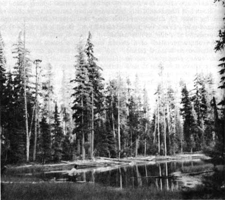
One of the few permanent ponds in Crater Lake National Park is located along the south entrance road a short distance north of the Cold Spring Campground. To reach this interesting body of water, it is necessary to drive into an old stone quarry on the west side of the south entrance road about one-half mile north of Cold Spring. The pond can then be found by climbing around the south end of the quarry and walking about 200 yards to the west. It is located at 6250 feet altitude, is about 300 feet long and 100 feet wide and has a maximum depth of approximately four feet.
Curiously, this pond has in the past periodically become “lost.” It is not shown on the topographic map, consequently, when those who know its location leave the service of the park, there is no way for newcomers to find it. During the early part of the 1951 season, Dr. Donald S. Farner told us that he had seen this little body of water during his first season in the park but had not found it since that time. He suggested that we locate it because, being permanent, it had the possibility of containing animals and plants that would not be found in the temporary ponds which exist in other parts of the park.
Our inquiries among the members of the park personnel revealed that the pond was not quite as lost as we had originally thought. Ranger Paul Turner had seen it in 1938, electrician James Kilburn had visited it as recently as 1950 and Charles True, for many years a worker at Crater Lake, had climbed around the quarry to this body of water about 18 years ago. However, the fact remained that it had been seen only infrequently and, as far as we could learn, had never been explored for plants and animals.
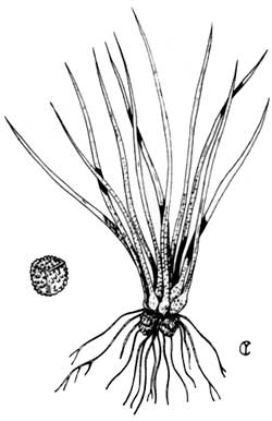
On the evening of September 5,1951, we made the climb around the quarry and found this elusive pond. The accompanying photograph shows how it appeared to us at that time. We were delighted to discover that the bottom of the pond was covered with a plant that had not previously been recorded from the park. This curious species is a quillwort, Isoetes braunii Durieu, a non-flowering vascular plant in which the spores are borne in sporangia that are imbedded in the basal portions of the quill-like leaves. Dr. Charles F. Yocom has prepared a drawing of this quillwort which shows clearly both its general structures and the detailed appearance of its megaspore as seen under magnification. The quillworts were growing so abundantly over the bottom of the pond that, as one waded through the water, he left a trail of uprooted quillwort behind him.
We have recorded the position of this pond on the large map that is kept in the Ranger’s office. Perhaps that record and this Nature Notes article will enable future park workers and visitors to find and enjoy this beautiful and interesting aspect of Crater Lake National Park.
Quillwort Pond
As might be expected from his articles in this issue, salamanders are the chief interest in the life of Ranger- Naturalist James Kezer. A good observer clad in hip-boots, he spent his free time last summer in the wet, boggy spaces of the park and Oregon Caves National Monument. The result was the addition of several aquatics to the flora of the regions. His first find was a quillwort, Isoetes sp., in Lower Biglow Lake above Oregon Caves. Later he found his “lost” pond near Arant Point floored with it.
Tho it is not indicated upon park maps, this small pond was not unnoticed in the past. There is a current story that it was planted with fingerlings in the early thirties. Their introduction was the signal for numbers of pelicans to visit the shallow waters until the last fish was consumed. Former park ranger Jack Frost said that he had heard this story in 1936. He made two trips to the pond in 1937, never to see waterfowl of any kind on or near the water.
Permanent ponds inside the park boundaries are rare. Because of its history, the park concluded that this pond should bear an official name. For the purpose, I weighed the possibilities of Isoetes, what with its Greek origin, euphony, and dieresis, but settled instead on simple “Quillwort Pond” to propose through channels to the Board on Geographic Names.
The plant is of interest. Its nearest relatives are the club mosses and scouring rushes (equisetums or horsetails). They are aquatic or marshloving, and have been traced back in geological time to the Miocene. They are characterized by an extremely short, corm-like stem from which grow 10 to 100 quill-shaped leaves. The bases of the leaves are spoon-shaped, in which grow the fruiting bodies or sporangia that are of two sizes and kinds. Larger spherical macrospores occur in the outer leaves while numerous, triangular microspores grow in the inner leaves. Size and sculpturing of the spores form the important differences between species.
The park specimens were examined by Dr. L. R. Detling of the University of Oregon who identified them as I. braunii Durieu. He bases his conclusion on the presence of very long papillae, almost spines, on the megaspore coat. Dr. LeRoy Abrams of Stanford gives the range of this species as far northern, coming southward only into Washington and Idaho. Further investigation will be reported in a future issue.
Other pages in this section