Birds and Insects Abundant
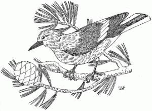
Bird-life is abundant, and is met with at all elevations. Over seventy species have been described from the park. Some of the most beautiful are the Western Tanagers and the attractively-hued Grosbeaks. The Clark’s Crow, whose raucous voice and magpie-coloring render him instantly noticeable, is the most conspicuous. Eagles occasionally nest upon the rocky crags of the higher points of the rim.
Insects are present in infinite number and variety, ranging from destructive wood-beetles to the handsome Lepidoptera. This past summer the park witnessed a migratory movement of an unbelievably vast number of California Tortoise-shell Butterflies (Aglais californica), whose orange and brown wings brightened the landscape for weeks.
Each of the three life zones contains a wide variety of quite different local habitats, ranging from rocky cliffs, talus slopes, and pumice flats, to morainal meadows, alpine swamps, stream banks, and the sheltered forests. Each habitat has its own characteristic inhabitants, and the relation of each group to its surrounding conditions presents a fascinating problem, or series of problems, to the ecologist. But although each special environment has its distinctive vegetation, there are certain species of plants–and animals, too– which occur almost constantly throughout a given zone, and yet are quite closely confined to that belt. These species are known as “zone indicators,” or “zone markers.”

from L. Howard Crawford, Nature Notes, Vol. IX, No. 1, July 1936.
Many types of vegetation are suitable for the role of markers, but those most available and conspicuous in the park area are the pine trees and their allies. In the Hudsonian Life Zone we find the White-bark Pine (Pinus albicaulis) and the Mountain Hemlock(Tsuga mertensiana) occurring constantly. The Western White Pine (Pinus monticola)and the Lodge-pole Pine (Pinus contorta var. murrayana) unmistakably denote the Canadian. In the Transition Zone we find the Western Yellow Pine (Pinus ponderosa),the Sugar Pine (Pinus lambertiana), the Incense Cedar (Libocedrus decurrens), the Douglas Fir (Pseudotsuga taxifolia), and other conifers.
By the means of such a framework, there can be arranged more than three hundred and fifty species of vascular plants (ferns, conifers, and flowering plants) which have been collected here. At one time it was thought that this was an “Endemic Area,” i.e., one which contains highly peculiar species, to be found nowhere else–as the Redwood(Sequoia sempervirens) is “endemic” to the coast of northern California and southern Oregon. However, most of these pseudo-endemics have been subsequently reported from other stations, but they are still very rare and interesting. Some of the most unique are the Oregon Moonwort, or Pumice Grape-fern (Botrychium pumicola), the Pumice Sandwort (Arenaria covillei), and the Mazama Collomia (Collomia mazama) — a beautiful blue relative of the phloxes.
The Blueness Still Unsettled
In addition to the general and specific problems in geology, petrology, biology, and ecology, there are several miscellaneous questions of significance, which await definite settlement. In the first place: is the unsurpassed blueness of the waters of the lake due to dissolved minerals or to some light phenomena? A thorough chemical investigation should reveal whether the azure hue depends upon a colloidal solution of molybdenum or aluminum sulphate, or not. Also, no one has ever yet shown the existence of any outlet or inlet to the lake, and, while the existence of the latter does not appear to be necessary, the absence of the former would plunge us into a new mystery. If there are no outlets, why does not the water overflow its basin, since the precipitation exceeds the evaporation?
Only a brief presentation of some of the more obvious subjects of scientific interest has been attempted here. An ardent student of nature, in almost any field, will find that an investigation of the possibilities of research in the park brings to light an ample number. Any trained worker, devoting his interest and activity to this rich region, will benefit not only himself but all the knowledge-thirsty visitors to whom his findings become accessible.

from “Crater Lake Currant,” L. Howard Crawford, Nature Notes, Vol. VIII, No. 3, September 1935.
A Century of Measuring Lake Levels
By Tom McDonough
In 1886 a group of men representing the United States Geological Survey measured the depth of Crater Lake in several places. Using piano wire and a lead weight, they determined that the greatest depth of Crater Lake to be 1,996 feet. Seventy-three years later, another U.S.G.S. survey corrected the earlier measurement by using sonar and established the greatest depth at 1,932 feet. This depth is referenced against a surface elevation of 6,176 feet. Because the lake loses water through evaporation and seepage, there are times when the lake depth is less than the 1959 calculation. Since inputs vary from year to year, there must also be periods when the 1,932-foot calculation is exceeded.
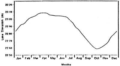
The primary input for Crater Lake is the annual precipitation the region receives. This is close to 69 inches on average, as measured at Park Headquarters. The lake level rises from October to April because input exceeds output, as seen in Fig. 1. As precipitation lessens in late spring, the lake’s level stabilizes until mid June. This is due to the balance among evaporation, seepage, reduced precipitation, and run-off from melting snow. For the rest of the summer, the lake level falls at an average daily rate of .675 centimeters per day, or about 25 hundredths of an inch. The lake is usually at its lowest level at the end of September. For the lake to return to the same level year after year, the input as measured at Park Headquarters must be 66.9 inches. This amount is dose to the long term average measured at this site.

Figure 1. Annual cycle of water level. Fifteen-year composite of 1996-1971, 1975-1976, 1979-1985. Units: Elevation in meters minus 1859.28m.
The lowest lake level was recorded on September 10, 1942, when the lake dropped to a surface elevation of 6,163.20 feet. This reading is related to low precipitation amounts observed regionally during the 1930s. In 1975, the lake level reached a historic high when it rose to a level of 6,17934 feet. There is some evidence that the lake may never get much higher than this 1975 measurement. Lichen stains on rocks near shoreline indicate that the water may never have been above 6,180.50 feet. This evidence is also consistent with observations that live and dead trees have rooted just a few feet above the observed lake level maximum.
Since Crater Lake is thought to have no other significant input, lake level is subject to abrupt changes year to year when snowfall amounts vary. For example, the lake level rose two and a half feet between 1951 and 1952. Conversely, it fell 3.40 feet between 1976 and 1977. When snowfall accumulation reaches levels near historic averages, little change occurs to the lake level from year to year. As noted earlier, the range of lake level measurements has varied some 16.14 feet over the past century. The 30 year average for the lake’s surface elevation is 6,175 feet. This is slightly higher that the average for the period of 1907 to 1988, which is 6,170 feet; the latter elevation reflects the low water level observed in the 1930s and early 1940s.
During the summer of 1991, the lake’s surface elevation was estimated to be 6,170.80 feet on July 31. Assuming that there was no significant precipitation through September, the lake level might have been near 6,170 feet on September 30. This would be the lowest level since the early 1950s. Like the low lake levels recorded earlier this century, the present trend seems related to less than average precipitation amounts beginning in 1985.
A hundred years of lake measurements have taught us that we should not assume that the level of Crater Lake does not change. Thirty-year or even hundred-year averages can be very misleading. What we observe one year or over one decade is no indication of what can happen the next. Furthermore, since lake level changes are related to regional climatic events, it is impossible to forecast the next season’s lake level accurately. When the figure of 1,932 feet is cited as Crater Lake’s depth, this is only one observation made at a given time during the recent past. As with any dynamic system, the depth of Crater Lake and its elevation above sea level is never a fixed value. Each rise and fall is a response to forces imposed by nature from outside the caldera.

