
Fire as an Agent of Change
In 1994, Crater Lake National Park experienced 44 forest fires. These fires occurred throughout the park, from the Boundary Springs area to Sharp Peak and Annie Creek. Contrary to the widely held belief that fire in the forest is devastating and destructive, the fires at Crater Lake were beneficial products of a natural process eons old.
The vast majority of these fires during the 1994 fire season were under one tenth of an acre. A few grew to an acre or two, but less than five surpassed ten acres. One event, known as the Agee fire, was particularly interesting. This fire took nearly a week to find as the lookouts kept losing sight of the furtive smoke. Rugged topography south of the lookouts at Watchman and Mount Scott prevented a clear pinpointing of the smoke. It would pop up in the afternoon for a short time and then disappear, laying down in the tree canopy. When the smoke could be seen, it seemed to be on the southwest flank of Crater Peak.
A team of two firefighters were sent to locate the source of the elusive smoke. After four hours of climbing up and down the steep slopes, pushing through thick stands of snowbrush, Ceanothus velutinus, and sliding down scree, they stopped for lunch. In casually scanning the northern skyline, they saw something that made the drop their sandwiches and pick up their binoculars. They found the smoke, but it was not on Crater Peak. Although in line with the lookout tower on Watchman, the fire was on a ridge above the East Fork Annie Creek–over a mile and a half away! Since a deep canyon lay between them and the fire, they ate while hiking out. This turned into a near run so that they could get back to East Rim Drive and revealed itself, less than one and a half mile from headquarters. In an ironic twist, this fire turned out to be one of the closest to home.
Locating this fire on the park map is easy. Place your finger at Park Headquarters and follow East Rim Drive until it crosses the east fork of Annie Creek. Turn south and go about three quarters of a mile. On the west side of the creek, a steep slope runs up from the canyon bottom to the 6,000 foot level. You will see a ridge dividing the middle and east forks of Annie Creek. Along this ridge the fire burned slow but steady through a mature forest consisting of Mountain hemlock. Tsuga mertensiana, and Shasta red firAbies magnifica-procera. Upon discovery, the fire covered less than half an acre. The decomposing layer of needles and twigs smoldered and smoked heavily. Occasionally the crackling of burning live needles broke the quiet. Small seedlings, with their branches near the ground, were torching. This sent flames up as high as three or four feet, dying out as quick as they started.
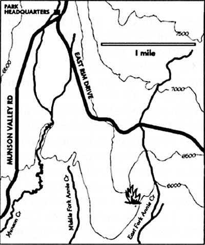
Map by Susan Marvin.
There have been fires around what is now Crater Lake National Park for many thousands of years. Chances are, however, that what became known as the Agee Fire was the first in this part of the forest for quite some time. Far from being static and seniscent, the forest is constantly changing. Agents of change such as wind, precipitation, and fire alter species composition and stand density in the forest. These processes occur with varying frequency, depending on the type of forest. The frequency of fire in a given locale can be averaged to obtain its Fire Return Interval. This number can vary greatly throughout a forested area depending on the species makeup, altitude, aspect, topography, and prevailing weather patterns.
The forest where the Agee fire burned has a mean fire return interval of approximately 40 to 50 years. This means that the fire was burning on land that probably had not burned in the last 50 years or more. The variability among fire return intervals is usually very broad. For example, one researcher may find evidence of fires within the last decade, while another might find that a similar area had not burned for 120 years. The accuracy of these numbers usually depends on the extent of the survey.
The Agee fire burned for about eight weeks before being extinguished by snowfall in early November. During this time, firefighters made efforts to contain the fire within a fixed perimeter. With many other fires burning throughout the park at the same time, people and equipment were stretched thin. The weather remained hot and dry for several weeks after the fire started. Temperatures in the 80’s and humidity as low as 13 percent pointed to conditions normally associated with high fire danger. For the most part, however, the fire burned slowly through the underbrush and duff layer.
To study the effects this fire would have on the forest, plots were established in the path of the spreading flames to measure various components of the stand structure. These plots quantified the amount of burnable material, or fuel, and the quantity and density of live trees and shrubs. By reading the plots before and after the fire the change caused by the fire could be measured.
The results of these measurements point to the fact that fire is rarely a devastating event. Even the massive fires at Yellowstone in 1988 were agents of change that led to massive regeneration of the forest. The Agee fire, burning through a period of high fire danger, altered the forest in ways that were not as dramatic as all-consuming fire storms. This fire killed just 13 percent of the trees over ten feet tall, and only 41 percent of the trees under ten feet tall. The fire thinned out the young trees, providing better conditions for the growth of those that remained. What few large trees that were killed now allow for more sunlight to reach the forest floor where grasses and shrubs will sprout next year. During the fire many signs of elk were present an should be again once the forage returns. The large dead trees will also provide valuable habitat for birds, bats and insects. In topping out at 30 acres, the Agee fire left a forest changed but far from devastated.
Another change documented at the Agee fire involved deduction of the fuel load. This is composed of dead and down sticks and logs, as well as duff and needles. From a pre-burn level of 17.96 tons per acre, the fire consumed 14.53 tons per acre of fuel. This 81 percent reduction accomplished several things. Stored nutrients were released, making them available for future plant growth. In addition, such reduction can prevent the unnatural build up of fuels (which can lead to high intensity fires) that results from overzealous suppression of all fires.
Suppression of all fire at Crater Lake National Park was practiced for roughly 75 years. During that time much natural change in the forest has been stymied. When the snow began to fall in early November, there was still heat in the Agee Fire. By this time the fire crews were long gone and the fire cache was closed for the year. Snow fell gently and the temperature hovered around 30 degrees. Standing in the midst of the burn, I warmed my hands over embers in a slowly burning log. I thought about the regrowth, elk, and more fires in the summer of 1995.
Further Information
James K. Agee, Fire Ecology of the Pacific Northwest Forests. Washington, D.C.: Island Press, 1993.
C.B. Chappell, Fire Ecology and Seedling Establishment in Shasta Red Fir Forests of Crater Lake National Park. M.S. thesis, University of Washington, Seattle, 1991.
Doug Lowthian is a seasonal firefighter at Crater Lake National Park.
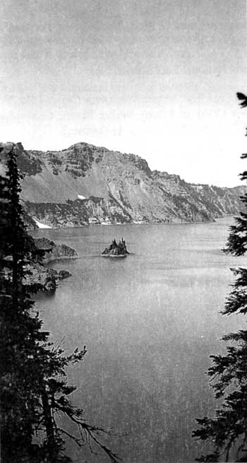
Phantom Ship from Kerr Notch in 1936. Homer Marion photo, NPS files.
Ancient Remnants in Snow Crater
Craters are geological features usually associated with composite volcanoes and the top of cinder cones. Found throughout the park, they are generally less than a kilometer (5/8 mile) across and formed when volcanic material is ejected through a vent of an active volcano. Calderas, by contrast, represent volcanism far beyond the activity that is typical of eruptions associated with craters. To put this in perspective, the four to six mile-wide depression filled by Crater Lake is a caldera while the crater on Wizard Island’s summit is only a couple of hundred yards across.
 Wizard Island has a crater; Crater Lake is inside a caldera. |
That crater on Wizard Island formed after Mount Mazama’s climactic eruption, so it is clearly discernible. Cinder cones such as Crater Peak, Maklaks Crater, Red Cone, and a number of unnamed points on the park map have craters obscured by erosion, pumice and ash because they appeared prior to the cataclysmic event of roughly 7,700 years ago.
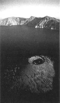
Although not abundant, the park contains several post-Mazama craters in addition to the one on top of Wizard Island. One easily reached by a short walk from the west rim drive near Hillman Peak is Williams Crater, sometimes called Forgotten Crater on older maps. Another one is located some distance from any road, near the park’s south boundary. Scoria Cone is quite unlike the other two, in that it has an exposed crater-like depression or what some geologists have described as a pit crater.
Most, if not all, of Scoria Cone resulted from a north-south fissure through which lava extruded 25,000 to 45,000 years ago. It is one of three prominent cinder cones built on well-rounded lava flows whose appearance show evidence of glaciation, much like those in the vicinity of nearby Union Peak. Like many other cinder cones, Scoria Cone has a crater filled with pumice and ash. There is, however, a deep rectangular depression or pit on the north end of the older crater floor. Measuring roughly a hundred yards long and 50 yards across, the pit has precipitous walls dropping away some 130 feet to the top of a snow and ice plug.
In the 1940s one park naturalist noticed that snow in this plug is permanent, even when summer melting in other parts of the park has long dispatched any sign of winter. He named it Snow Crater, not knowing that the snow and ice extended 150 feet down a chimney which once provided the conduit for lava sometime in the past. He could not know because few people are foolhardy enough to try a descent to the plug, let alone attempting to go between the conduit’s walls and the ice.
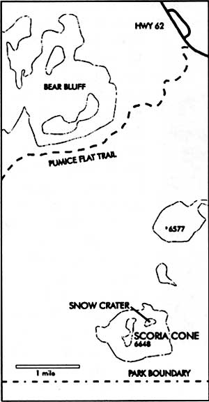
Map by Susan Marvin.
Even so, in 1977, after one of the driest years on record, a team of park rangers explored where no one had ever been previously. They reached the plug’s bottom and found several rooms of various sizes. Two of the rangers retrieved pieces of wood entombed in ice from near the bottom of the plug. One of these specimens was subsequently identified as Douglas-fir, Pseudotsuga menziesii, by a wood technologist at Washington State University. Its resting place piqued the curiosity of researchers connected with the park, as no Douglas-fir are known to occur presently at 6,300 feet anywhere near Crater Lake. Although badly degraded, the wood showed breakdown in cellular structure that is caused by hot water or steam. This led to speculation that the fragment might have been in the pit crater while it was still active.
Although radiocarbon dating of this wood held the prospect of providing additional insight to mysteries surrounding volcanic activity at Scoria Cone and the vegetation history of this area, no one could secure funding for necessary laboratory work for the next 17 years. Only in 1994 did a sample specimen finally reach a radiocarbon dating lab for an age determination. After calibration (since radiocarbon years may be tree ring corrected to reflect calendar years) it was reckoned that this piece of Douglas-fir is approximately 3,640 years old. The obvious interpretation of this evidence is that a mixed conifer forest, as seen today in the park’s panhandle (the irregularly-shaped parcel of land near the south entrance), flourished at Scoria Cone during a period of warm-dry summer climate roughly 4,000 years before the present. Since conifers such as Douglas-fir are long-lived, the wood sample may indeed be one of the last of this species to grow near what became Snow Crater at Scoria Cone. The nearest forest of similar composition 3,600 years later is located a few miles downslope, but at 4,500 feet in elevation near the park’s south boundary.
Since three of us felt the need to locate any Douglas-fir presently living close to Scoria Cone other than those previously mentioned, we hiked there on August 25, 1994. After 30 minutes on the Pumice Flat Trail, it took another hour or so by traversing cross country to reach the top of a cone just north of our destination. We could find no evidence of Douglas-fir along the way, nor did any appear on the short jaunt to Scoria Cone. Instead we found a subalpine forest of lodgepole pine, Pinus contorta v. murrayana, western white pine, Pinus monticola, true fir (white fir, Abies concolor, and red or noble fir, A. magnifica-procera), and mountain hemlock, Tsuga mertensiana.
Once we reached Snow Crater, it did not take long to realize why the rangers of 17 years earlier felt justified in closing this vent to any future explorations. Remnants of wooden park signs to this effect could still be seen as we walked around the pit’s perimeter. It was then that our attention became riveted to a curious three-needled pine clinging to the precipitous north wall some 200 feet above the plug of snow and ice. Just why it is there constitutes an interesting question. Surprisingly enough, what has been called Ponderosa pine, Pinus ponderosa, in lower elevation mixed conifer habitats can be found today in small subalpine habitats near Crater Lake’s caldera rim, and on warmer southwest slopes of cinder cones within and near the park. In addition to the possibility of this three-needled pine being ponderosa, there are at least two others. These include Jeffrey pine, Pinus jeffreyi, whose northern distribution is on serpentine substrates near the Illinois Valley over 100 miles southwest of Crater Lake, and Washoe Pine, Pinus washoensis, a rare and almost unknown species found in the mountains bordering the Great Basin.
Trees can often serve as thermometers with sensitivity to temperature changes induced by fluctuations in climate. Cold abbreviates the length of growing seasons, thereby limiting critical processes such as photosynthesis. The result is a narrow growth ring and long periods without viable seed production. Even cold-hardy ponderosa pines would find survival in the short growing seasons and frequent deep snowpacks of subalpine habitats difficult.
The mixed conifer forest (with Douglas-fir as an associate) seen today within the neighborhood of the park’s panhandle has not always been situated there. At the time of Mt. Mazama’s great eruption, 7,700 years ago, a climatic interval known as the Altithermal or Hypsithermal Period was underway. It began some 8,000 years ago and persisted for approximately four millennia. Marked by significantly warmer and dryer summers than at present, this time featured climatic changes which altered growing conditions which favored the upslope migration of the mixed conifer forest. Associated advances and retreats of forest community borders along elevational gradients are well documented throughout western North America.
Changes in vegetation zone elevations are affected by shifts in critical growing season temperature and moisture regimes. A shift to cooler, more moist conditions following the Altithermal Period spurred a retreat of the mixed conifer forest to lower elevation habitats over the past few thousand years. Isolated and disjunct stands of three-needled pines within the subalpine zone today represent local pine variants. As relicts of past environments, they may link prehistoric forest assemblages to our time and place. The sentinel pine grasping the volcanic rock for moisture and nutrients above Snow Crater may hold one key for gaining a better understanding of the linkage between past and present. Our visit to Scoria Cone provided an opportunity to interpret the present scene and wonder about the relationships resulting from those geologic, climatic, and biological forces present during the era when a 12,000 foot Mount Mazama dominated the landscape.
Steve Mark is the park historian at Crater Lake. He has been editor of Nature Notes since its revival in 1992.
Ron Mastrogiuseppe is a former seasonal employee at Crater Lake. He is now based in Burns, Oregon, where he is an ecologist.
Moonmilk and Cave-dwelling Microbes
Microbes lie as far from charismatic megafauna such as deer, bears, and bobcats as you can get. Studying these “forsaken fauna” is difficult because you cannot see them. Their geologic equivalent is mud, but even with x-ray diffraction and other high tech methods, the small particle size of muds can challenge the most dedicated researcher. When combined in caves, however, microbes and muds can form sediments known as moonmilk.
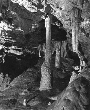 formations in Oregon Caves Oregon Department of Transporation photo. |
Even the name has the lure of mystery. Its origin is from the German Mannlimilch,meaning “little earth-man.” European peasants used moonmilk for centuries to heal infected cuts in livestock. Some believed that gnomes put this substance in caves for people to use. The white mud seemed to kill infections and speed healing at supernatural rates. Like much of what is in folklore, there is more than a germ of truth in these tales. Much of the calcite moonmilk sampled by investigators contains actinomycetes, which are the main producers of antibiotics.
Moonmilk is a textural term for a very fine, white cave material that absorbs a lot of water. Wet moonmilk looks and feels soft and pasty, somewhat like white cream cheese, when rubbed between the fingers. Dry moonmilk resembles talcum or chalk powder, in that it feels hard and crumbly. Moonmilk often contains 40 to 70 percent water, while organic material may make it even more plastic and slippery.
It is likely that organic activity plays a role in the buildup of some moonmilk, especially the calcite kind found in Oregon Caves. Calcite moonmilk can contain such bacteria asMacromonas bipunctata, along with cyanobacteria, fungi, and green algae. This microflora probably assists in breaking down minerals in the wall rock and adding them to the moonmilk. Moreover, researchers have found that the longer it takes water to reach the cave, the more likely it is that some of the organics will be consumed enroute. In general, water dripping into the deeper parts of Oregon Caves has less organic content than water reaching shallower parts.
Humans have impacted bacteria in moonmilk, as well as other microbe populations in Oregon Caves. An inventory done around every survey point in the cave shows a marked decrease in “cave slime” (mostly actinomycetes bacteria) growing on walls near the cave trail. Decline in these organisms could well be the result of lint and other visitor-induced organics that find their way to cave walls. As a result, non-native bacteria adapted to a high energy food source outgrow and outcompete the slow growing cave slime adapted to low energy foods. Cave slime may also have suffered further adverse effects by visitors touching the cave walls, or through the past practice of spraying those walls with bleach to control exotic plants.
As an example of their value to resource management in the park, microbes have been utilized to reconstruct the size and shape of prehistoric entrances at Oregon Caves. Since the natural openings are now highly modified, an inventory of the directional orientation of popcorn-shaped speleothems was needed so that gates could be built with partial restoration of those conditions resembling prehistoric air flow. The cave inventory also showed that exotic microbes contributing to rounded vermiculations (or “clay worms”) are more common near the main trail, while the more complex forms of these lines on cave walls are prevalent further from the trail. Analysis if the rounded vermiculations show high amounts of lint and exotic cyanobacteria. The rounded clay worms will be removed, as they appear to be largely caused by lint and artificial lights.
Deposition of lint, skin, and hair in Oregon Caves does not appear to impact native microbes as much as in some other caves administered by the National Park Service. Knowing this has allowed flexibility in the design of a new cave trail. Rather than having settling “ponds” and a foot-high, lint-trapping curb on both sides of the trail along its entire length, only certain areas will be curbed or have drainage concentrated. If these areas trap substantial lint and non-native organic runoff, then additional curbs, drains, and settling ponds will be added and the areas cleaned more frequently. This system will allow for a more natural flow of water and air across the trail, yet will trap lint and other human-associated organics where they might threaten cave biota. The result should be a better balance between allowing for visitor use and preservation of the monument’s primary resource.
John Roth is the natural resources management specialist for Oregon Caves National Monument.
Other pages in this section