
Diving in Crater Lake
Despite what some people might like to think, bubbles coming from the surface do not usually signify arrival of the Crater Lake Monster. What you are probably seeing is a group of SCUBA divers. In choosing from among all the other recreational activities available in the park, they prefer to dive in the crystal clear (but cold!) water. Crater Lake has attracted people from all over the world for almost a century, including divers from as far away as Florida. If you are considering diving below the deep blue surface of this famous lake, there are a few things you need to know.
It is important that you understand the lake surface is just over 6,100 feet above sea level. Since Rim Drive (from where Crater Lake is reached) climbs to an altitude of 8,000 feet, you need to use high elevation dive tables. At these heights an average 60 foot dive has an equivalent adjusted depth of 81 feet, a distance considered risky when the nearest full service decompression chamber is over 400 miles away! The water can be very cold with below surface temperatures hovering around 37 degrees Fahrenheit. This is why National Park Service staff recommend a full wet suit, (or even better, a leak proof dry suit) be used.
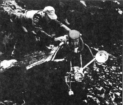 Allen Cherry and unidentified ranger, first recorded dive in Crater Lake, August 1956. Photo by Life photographer A. Y. Owen.
The trip to the lake surface can be quite an adventure for a diver with full equipment. You must descend 700 feet on a trail and return without mechanized or wheeled assistance. Once at the lakeshore, you may want to explore Cleetwood Cove since it is the closest area for diving and has several enjoyable features. One is a relatively shallow place just east of the boat dock, where depths are around 10 to 20 feet, before dropping beyond the range of sport divers. In this long but narrow area, one can find large boulders that provide habitat for two types of fish in Crater Lake — rainbow trout and kokanee salmon. Another interesting feature is the steep wall that suddenly drops away from the narrow shoreline. With the sharp angle of this precipice and crystal clear visibility, one may feel a sensation of floating across a distant cosmic landscape.
Wizard Island is the other main area for diving, though access to it is only by concession tour boat. Be sure to call ahead for current prices and boat schedules. The waters surrounding the island offer similar precipices to Cleetwood Cove, but a wide and somewhat shallow area called Skell Channel is also close at hand. Shallow water makes diving safer and the area around Wizard Island has more than a few interesting features. One is the sharp volcanic rock that dots subsurface terrain and is close enough to the surface to be examined without air tanks. Fumarole Bay is also accessible from the island and provides a view of the submerged geological features for which it received its name. The fumaroles were once vents for gases released while Crater Lake formed and many of them can be seen at a depth of 50 to 60 feet.
It is hard to describe the feeling of swimming along a great precipice which drops to great depths, while suddenly encountering a curious trout who approaches from a deep blue background and then quickly darts beyond your reach. Please remember, however, that collecting indigenous rocks and native biota in Crater Lake is not permitted. These items should be left in place so that they may be enjoyed by this and future generations. Also note that spear fishing is prohibited in the lake, but fishing with rod and reel is allowed (since rainbow and kokanee were introduced) and a good way to pass the time between dives.
Prospective divers need to arrange for a special use permit before coming to the park. These can be obtain by writing to the Chief Ranger and should be done several weeks in advance so that park staff have a chance to inform you of restrictions and regulations which may be in effect at the time of your dive. These rules are intended to protect the diver, other park visitors, and the lake’s ecosystem. The required permit is $50.00, which is used to cover administrative costs associated with the dive. All permits must be obtained in person, a stipulation that allows park staff to notify the diver of any changes in restrictions affecting the dive, while also providing a chance in verify diving certification and review safety procedures. All members of the dive group need to attend this briefing. As you prepare, remember one of the first rules of diving: plan your dive and dive your plan. If you do, and are prepared for a variety of challenging circumstances, then a fascinating adventure in diving may await you.
John Broward is a backcountry ranger stationed at Crater Lake National Park.
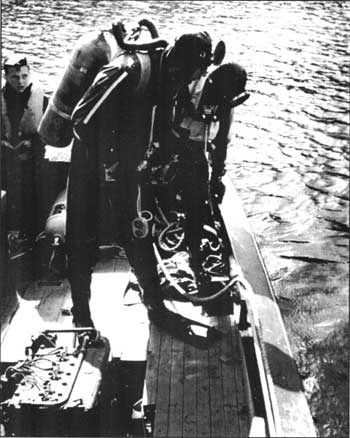 Allen Cherry and Phil Bayouth with unidentified child, first recorded dive in Crater Lake, August 1956. Photo by Life photographer A. Y. Owen.
The Old Man of the Lake
On the calmest of days and with a bit of luck, one might be able to see a boat on Crater Lake or even a floating weather station from the rim. The sharpest eyes may catch a glimpse of something very peculiar on the lake surface, what appears as a very small and whitish dot. Like other objects seen from a distance, however, its size from the rim belies how large it actually is. This untethered voyager has been observed even before the lake became part of a national park and seems to be as unchanging as Wizard Island or Phantom Ship. For just as long this denizen of the deep blue has been called the Old Man of the Lake.
Many, if not all, lakes contain floating and sunken woody material. Few lakes, though, have a large conifer floating in a vertical position which appears to be rooted to the bottom of the lake wherever it is seen. The Old Man is about 30 feet long and has a diameter of roughly two feet at waterline. Its top stands approximately four feet out of water and is bleached white. The exposed end is splintered but buoyant and wide enough to support a person’s weight.
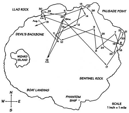
 Map showing the Old Man’s movements, August 1938, by John E. Doerr.
The Old Man poses a few questions which have been asked continually by park employees and visitors alike. One concerns his age. Joseph S. Diller published the first geology of Crater Lake in 1902, the same year that this area became a national park. In his work, a short paragraph describes a great stump he found six years earlier to be rooted below the lake’s surface on the west shore of Wizard Island. Diller wrote that if a tree once grew in this location, the lake must have been much lower in recent times. He did not, however, hypothesize about the tree in question being the Old Man. Instead, Diller stated that trees commonly slide into Crater Lake, roots first. This was attributed to the caldera’s steep slopes, but how is it that only one log floats vertically in Crater Lake? There may be a specific set of circumstances which give rise to this phenomena. The Old Man presently meets all of the criteria. Perhaps this is similar to the occurrence of life in this universe — it just happens to fit the criteria!
In 1896, the Old Man floated just as it does at present. This, of course, prompts the question of how a log can float in such a position. Some have suggested that when the Old Man slipped into the lake, he had rocks bound within his roots. This might naturally make him float vertically, though no rocks appear to still be there. At any rate, the submerged end could become heavier over time through being waterlogged. Acting like the wick on a candle, the shorter upper portion of the Old Man remains dry and light. This apparent equilibrium allows the log to be very stable in the water.
Diller established that the Old Man could travel by tying bailing wire around the log and pulling it a short distance in 1896. Five years later Diller observed the Old Man to be a quarter mile from where he previously noted its location. This should not imply, however, that the log is slow-moving and confined to one part of the lake. An article which appeared in the 1938 volume of Nature Notes from Crater Lake documented that the Old Man rides the winds and currents to travel the lake’s entire surface area and can cover almost four miles in a single day.
Just as the verdure of the trees surrounding Crater Lake provide a sharp contrast to the deep blue water, green moss on the Old Man produces the same effect below the waterline for those fortunate enough to see this log at close range. In addition to the luxuriant growth of moss below the surface, there are spiders and ants above the water. Although limited in its diversity, this thriving community of life is just one of the ways that the Old Man commands attention.
Old Man near Wizard Island. Photo by J.S. Diller, 1901.
Since he can be seen virtually anywhere on Crater Lake, boat pilots commonly communicate his position to each other as a matter of safety. At two feet across and four feet high, the Old Man would not be someone to meet when traveling by boat across the lake. During the submarine explorations in 1988, scientists agreed to the idea of tying up the Old Man off the eastern side of Wizard Island. They reasoned that this navigational hazard had to be neutralized until the day and night shifts of research work had ended. Strangely enough, the weather went from clear to stormy and even scientists get nervous when this occurs on the lake. It seemed as if the weather was poor so long as the Old Man remained bound. Once the log was freed, however, the weather settled.
In more than one article about the Old Man, writers have expressed doubt as to whether he will persist through the stormy blasts of winter weather on Crater Lake. It now appears that mortals should worry about something else, because the Old Man has shown he knows this lake and can take care of himself. A better question might be will you be back to see the Old Man?
John Salinas teaches science at Rogue Community College in Grants Pass, Oregon, and has worked as a limnologist and seasonal naturalist at Crater Lake.
Llao Speaks
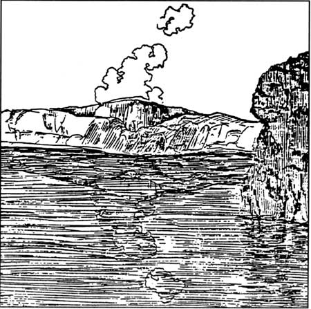
The story of Crater Lake centers on the destruction of a large volcano, Mount Mazama, and the subsequent accumulation of a deep blue body of water in its place. The events preceding and immediately following a final eruption of this volcano occurred at a time when Native Americans had already established themselves in the region. Whether the tales about the origin of Crater Lake told to the pioneers a century ago by the Indians actually date from prehistoric times may never be known. The stories describe a powerful spirit living beneath the mountain which the Klamath people called Llao. When angry, Llao would journey toward the surface and sit atop the mountain to speak with a voice like thunder. It is difficult to trace the relationship between these people and the spirit since this began so long ago. The occurrence of thunder is another matter.
Thunderstorms are more a phenomena of summer than winter in the region around Crater Lake. Winter thunderstorms are not unknown, but snowstorms are much more common. That is not to say that thunderstorms are common in the park during summer. If anything, these weather events are more of an exception. Summer weather is usually mild during July and August. Daytime highs are mostly in the mid to upper 70s and night time lows are in the 40s. A high pressure system aloft, the Pacific High, dominates our summer climate. The resulting warm and dry surface conditions at the higher elevations are ideal for camping and sightseeing from July to September.
Summer thunderstorms arise when moisture is lifted to form the tall cloud type called cumulonimbus. This happens when an upper level low pressure system located offshore of northern California directs moisture inland and across the Cascade Range. Thunderstorms can also occur in the area when moisture is drawn in a northerly direction along the western edge of high pressure centered over Nevada or Utah.
What happens inside the growing cloud to separate static charges, with a thunderstorm being the eventual result, is thus far imperfectly known. What we do know is that charges separate with the cloud’s base becoming negatively charged and the ground or water body below being positively charged. Since the air acts to insulate the charged cloud droplets, a potential of 3,000 volts per meter can develop prior to a lightning strike. The lightning bolt is electrical current connecting the ground or lake surface with the cloud base in order to neutralize the charge separation (lightning can also connect clouds to one another and isolated cells within a cloud). The flash of lightning, which lasts for less than a second, heats the nearby air to over 10,000 degrees Fahrenheit. The rapidly expanding air travels at supersonic speeds and produces a shock wave we hear as thunder. This sound is louder the closer an observer is to the discharge. Thunder is rarely heard if the observer is more than 12 miles away, even when the lightning is clearly visible. To estimate distance from a discharge, some people count between seeing a flash and hearing thunder. If five seconds elapsed between the lightning and subsequent thunder, then the discharge occurred about one mile away from the observer.
Lightning is attracted to high spots around the rim of Crater Lake since the distance between cloud base and surface is less. Since many park trails ascend points such as Garfield Peak, Mount Scott, and the Watchman, hikers should keep a watchful eye to the sky on days when cumulus clouds fill the air. As a safety measure, weather forecasts are posted at the two visitor centers each morning. In addition to trees and rock outcrops around the rim that attract lightning, Crater Lake can be struck by discharges from the clouds. Water conducts electrical charges easily, and with a surface area of roughly 25 square miles, the lake presents quite a target.
Lightning strikes over the park can be an awesome display of nature’s power. The associated thunder can fill the old glacial valleys of Mount Mazama and put fear into animals as well as humans. During a brief episode of thunder and lightning, as the wind bends the trees and marble-size hail pounds the ground, the ancient story of Llao comes to mind, reminding some of us that great power is nearby and can shake the earth.
Tom McDonough teaches science at Chemeketa Community College in Salem, Oregon, and has been a seasonal naturalist at Crater Lake since 1969.
 Karl J. Belser in Ernest G. Moll, Blue Interval, Portland: Metropolitan Press, 1935, p. 26.
Other pages in this section