

Volume 29, 1998
All material courtesy of the National Park Service. These publications can also be found at http://npshistory.com/
Nature Notes is produced by the National Park Service. © 1998
Introduction
This is the 50th issue of Nature Notes from Crater Lake, a milestone that took 70 years to reach. Publication began in 1928, but ceased twice, with the longest hiatus being for three decades after 1961. A symposium held in 1992 brought about the current revival of this serial and it has appeared every year since then.
The first issues of Nature Notes were mimeographed by park staff and appeared between one and three times each summer for the first ten years of publication. The present format and restriction to an annual volume started in 1950. National Park Service naturalists at that time wanted to economize on effort, but not at the cost of sacrificing the qualities which made Nature Notes a popular and inexpensive sales item. The background of contributors has since broadened to include employees working in other fields besides interpretation, in addition to long time friends of the park.
Volunteers came to the aid of this year’s volume with articles that underline the importance of observation. They are simply the latest in a long line of individuals who believe in the importance of an educational program at Crater Lake National Park. Two other volunteers, Jamie Halperin and Randall Payne, deserve special recognition, as they have put back issues of Nature Notes on the park’s web site (http://www.nps.gov/crla) last winter.
The Crater Lake Natural History Association encourages the reprinting of articles that appear in Nature Notes so long as credit is given to the authors and the association. CLNHA sponsors this publication as part of its commitment to assist the educational and resource management programs of the National Park Service. Please join them in this effort by becoming a member of CLNHA, and receive a 15 percent discount on all sales items. A list of these items can be obtained from the Business Manager, Crater Lake Natural History Association, P. O. Box 157, Crater Lake OR 97604.
This issue of Nature Notes is dedicated to the memory of Richard M. “Dick” Brown, who passed away on May 31, 1998. His career spanned the years from 1952 to 1970 at Crater Lake, where he had stints as assistant park naturalist, chief park naturalist, and then research biologist. Trained as a plant taxonomist, he combined academic rigor with a gift for interpreting to the public, thereby inspiring two generations of NPS employees who were privileged enough to know him.
Drawing by L. Howard Crawford, Nature Notes from Crater Lake, 7:3, September 1934.
Understanding the Bimodal Eruptions of Mount Mazama
Crater Lake partially fills a caldera within what was once Mount Mazama, one of the greatest volcanoes in the Cascade Range. Around 7,700 years ago it awoke with great fury and power. Roughly 13 cubic miles of magma erupted from the volcano, covering 500,000 square miles to the north and northeast. This eruption is considered by many volcanologists to be the most violent and devastating that the world has seen in the past 10,000 years.
This climactic eruption occurred in two phases. The first was a “single vent phase” in which ash and pumice were erupted from a single vent forming an eruptive cloud estimated to be 25 miles high. This disturbance emptied the uppermost levels of the chamber beneath Mazama, leaving it weak and unstable. As the eruption continued, it drained the chamber underlying the mountain so that Mazama began to collapse inward. This brought on the “ring vent phase,” whereby the remaining magma was pushed out of the mountain along the multiple areas where the upper volcano was cracking and falling. This occurred along circular ring fractures which is now where most of Rim Drive is located. This sequence of events brought about formation of a caldera, much of which we see today.
Perhaps the most unusual aspect of the climactic eruption is that it exhibited two distinct chemistries. The purpose of this article is to describe some field examples of those chemistries, because their appearance from the same volcano during one eruption is rare. Those examples should also help to illuminate how long differentiated magma compositions have characterized what we see around Crater Lake.
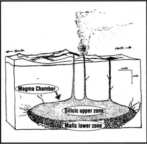
Volcanoes are commonly classified by their composition and their structure. Mount Mazama is an andesitic stratovolcano. Andesite is the most common lava type found at the volcano, and you can get a great look at andesite along West Rim Drive around the Watchman. The mountain’s structure was that of a sharp faced or angular peak, making it a stratovolcano. (Mounts Hood, Rainier, and Shasta are all stratovolcanoes as well). Mount Mazama is believed to have been a cluster of several overlapping volcanoes that began erupting at least 420,000 years ago. With each new eruption, more and more bulk to the mountain would be added. The Crater Lake volcanic system consisted of three main components: 1) several peaks like Phantom cone, Hillman peak, and Mount Scott that piled on one another to form a conglomerate main cone, which the lake partially fills at present; 2) about twenty smaller volcanoes called cinder cones located within the caldera and on its perimeter (of which Wizard Island is one of the more recognized examples); and 3) volcanic domes, the only ones of which are now beneath the water line. All three of these surface structure groups are believed to have been fed by a large magma chamber. Figure 1 illustrates the locality of that chamber in relation to the volcano.
| Figure 1. This is an illustration that modifies a figure drawn by C.R. Bacon of the U.S. Geological Survey. It shows how the chamber may have been layered into these two main zones during the time of the climatic eruption. Notice that the lighter, more silicic magma floats above the heavier, mafic magma. The magma chamber is less than four miles from the surface, and it is in the general shape of a lens. |
Each type of volcano is usually made up of a specific type of lava. This is due to different lavas having characteristics which result in distinct types of volcanoes. A few characteristics like viscosity, temperature, and water content vary widely when you look at different types of lavas. These variations that are observed in lavas play an important role in the way that the molten rock will eventually behave when they reach the surface. For example, if you were to drop cookie dough on one side of a plate, and pancake batter on the other side, they would behave differently. This is mainly because the thick and pasty cookie dough has much higher viscosity than does the runny pancake batter. When the dough and batter “cool” and harden, you would see two different shapes (one flat and one tall).
The cookie dough would be analogous to “silicic” lavas , while the pancake batter would be called “mafic” lavas. Silicic lavas usually build stratovolcanoes and domes, and mafic lavas make up the large and broad shield volcanoes and cinder cones. Figure 2a shows how lavas are broken-up into specific classes based mainly on compositional changes in the silica and oxygen.
Figure 2a. There are six main lava and ash types that are found in the Cascade Range. These types are classified as to the amount of silica they contain. Rhyolites have a high amount of silica, while basalts are at the low end of the scale. Lava and ash types (such as numbers 2, 3, 4, and 5) are intermediate.
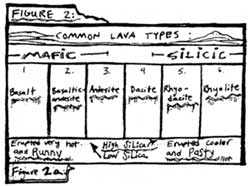 |
| Figure 2a. There are six main lava and ash types that are found throughout the Cascade Range. These different types are mainly classified in terms of the amount of silica that is in them. Rhyolites have a high amount of silica, and the basalts have a lower amount. Lava and ash types like numbers 2, 3, 4, and 5, are intermediate. |
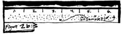 |
| Figure 2b. Let’s say that after a volcanic eruption, you go out into the field to gather up a sample of each type of lava and ash that was deposited. In the majority of eruptions, several types of lava and ash are found. If we were to plot each type found from a common eruption with a dot, the distribution would look like the figure above. Notice how all of the samples that you collected are randomly dispersed along a wide range of different types. There are no clumped groups. |
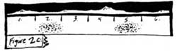 |
| Figure 2c. Now, if you were to do the same thing that you did in 2b, the types of ash and lava that you would find after the Crater Lake climactic eruption would only be from the basaltic-andesite (2.) and the rhyodacite (5.) groups. Let’s plot them on the same kind of graph that we did before. The dots would only be in those two regions. When the products of an eruption are limited to two distinct, clumped groups, the system that fed this rare eruption is said to be bi-modal. This is one of the aspects of the climactic eruption that makes Crater Lake so unique. |
** I should note that the 4 lava flows associated with the climactic eruption occurred up to 4,000 years prior to the collapse. Some geologists who studied Crater Lake do not even consider them to be part of the climactic eruption, but rather lava flows that simply preceded it. So, the dots in figure 2c are the ash deposits from the climactic eruption.
It is important to realize that the majority of volcanoes in the Cascade Range, as well as those around the world, are composed of closely related lavas and other eruptive material. In other words, it is uncommon for volcanoes to display material of one composition as well as large amounts of a completely different type. There is commonly some diversity in the lavas and ash in most eruptions, but their compositions are usually very similar to one another as shown in figure 2b.
Figure 2b. After most eruptions in the Cascades, field samples would show that a range of different lava and ash types (shown in Figure 2a) were deposited. The samples collected would be randomly dispersed among the various types, with their distribution similar to the above figure, so that no clumping of samples were evident in any group.
At Crater Lake, the volcanic system exhibits a pattern where there are only two very distinct groups of eruptive material (figure 2c). This is called a bimodal system. In the climactic eruption of the Crater Lake volcanic system, materials of two distinct compositions were erupted almost right after the other. In the first phase, an enormous (up to 30 miles high) eruptive cloud was produced. This sent large amounts of ash and pumice into the atmosphere and was eventually deposited in an area of nearly 500,000 square miles.
Now, in Figure 2c, if you were to do the same thing that you did in 2b. the types of ash and lava that you would find after the Crater Lake climactic eruption would only be from the basaltic-andesite (#2) and the rhyodacite (#5) groups. Let’s plot them on the same kind of graph that we did before. The dots would only be in those two regions. When the products of an eruption are limited to two distinct, clumped groups, the system that fed this rare eruption is said to be bi-modal. This is one of the aspects of the climactic eruption that makes Crater Lake so unique.
As the eruption continued, the cloud grew so large and heavy that the released gases could not hold it all up and some parts fell back down on the volcano. These super hot flows of ash and rock (called pyroclastic flows) rushed down the flanks of Mount Mazama, and deposited pumice with such heat and pressure that the pumice was compressed and welded. A deposit of welded pumice brought about the Wineglass Formation. This is the long orange colored deposit of ash and pumice that stretches from Llao Rock to Red Cloud on the north and east side of the inner caldera wall. It is illustrated in figure 3.
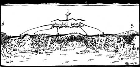
Figure 3. The Wineglass Formation (indicated by a thick black line) stretches from Llao Rock on the north side of the caldera wall to Red Cloud flow on the east side. It resulted from a pyroclastic flow in the first phase of the climactic eruption. The formation is best seen by hiking about 1/8 mile down the Cleetwood Trail, where a huge orange-colored ash flow tuff is evident. Tuff is a name given to ash when it is deposited so hot that it partially melts and recrystallizes, forming a hardened mass. Look closely at the tuff and you should see narrow lens-shaped pieces which are squished pumice from the hot flow.
Both the airfall ash and pumice and the pyroclastic flows forming the Wineglass were from the single vent phase. The single vent phase of the climactic eruption drained a large portion of the magma chamber, which left the volcano without a sturdy foundation. As it began to collapse inward, the force of the volcano was so great that it pushed the remaining contents in the magma chamber out along the fractures and cracks that the volcano produced as it broke inward. This activity sent out even larger pyroclastic flows than did the first phase. These rushed past the flanks and out into the once glaciated valleys and deposited rhyodacite and andesite. It is significant that all of the deposits from the first phase are high silica rhyodacite, while the pyroclastic deposits from the second (or ring vent) phase of that eruption began with rhyodacite but ended with basaltic-andesite. There were no intermediate or transitional compositions during the two phases of this eruption.
It is highly improbable that a magma chamber would show two very different types of chemistries unless the compositions were separated from each other into layers within the magma chamber. Layered magma chambers are not uncommon and, in fact, they are thought to be quite ordinary. Most of the time, however, these chambers exhibit a spectrum of layered compositions–not just two main ones like Mount Mazama, How one of these layered magma chambers forms requires some knowledge of the magmas themselves. Rhyolites, rhyodacites, and dacites are considered to be high in silica, explosive, and extremely viscous–hence the categorization “silicic”. Basalts, basaltic-andesites, and andesites are considered to be lower in silica, less viscous, erupted at higher temperatures (less than 1200 degrees Centigrade), more dense than the silicic types, and are classified as “mafic” magma. If we could, hypothetically, pour these two opposite types into a big bowl, the less dense silicic type would rise above the more dense mafic type. The same thing, in essence, happens in a magma chamber where the less dense silica-rich magma rides upon the mafic type in the general shape of a lens.
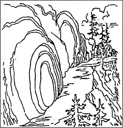
A layered, lens-shaped magma chamber is believed to have existed beneath Mazama when it catastrophically erupted about 7,700 years ago. The most impressive surface manifestation of the chamber can be seen at the Pinnacles, which are found in the once glaciated valleys of Wheeler and Sand Creeks just south of Lost Creek Campground. During the second phase of the climactic eruption, pyroclastic flows rushed down these valleys and filled them. These violent flows may have rushed for miles with speeds over 100 mph and then suddenly terminated. In stopping so abruptly, the flows trapped large amounts of hot gases at the lower levels. As these gases rose toward the surface, they heated the ash and pumice so that they partially melted and recrystallized. This recrystallization process changed the soft ash into a hardened material. The hardened ash and pumice formed around the path of the escaping gas and began to act as a chimney. Over time, streams flowed through these pumice and ash filled valleys. This left the resistant pinnacles standing and eroded the softer, unaltered ash. When you look at these pinnacles, you are actually seeing the subsurface structure that escaping volcanic gases created.
By observing closely, you will see that the upper regions of the pinnacles are darker mafic material, and the lower regions are lighter silicic material. Notice how sharp the contact is between the two (shown in figure 4). Remember how the upper silicic magma rests upon the denser mafic magma in the magma chamber. When erupted, this material would be in reversed sequence (just like if we were to erupt an “n”, it would land as a “u”). That sharp contact shows just how unmixed these compositions actually were, as if they were separated from each other in the chamber by a giant wall that disallowed any mixing to occur. The single vent phase had already removed a large portion of the chamber’s upper level, which was high silica rhyodacite. When the volcano began to collapse in on itself and erupt in the ring vent phase, the remaining rhyodacite was pushed out, as well as the underlying basaltic-andesite zone (you may wish to consult Figure 1 again to see the general structure of the magma chamber). When both of these layers erupted, the clouds of gas and ash were violently deposited in these valleys with the rhyodacite on the bottom, and the basaltic-andesite above it.
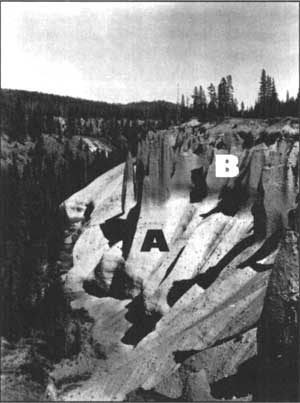 Figure 4. Distinct layers in the ash flow deposits at the Pinnacles. The “A” layer is rhyodacite that was extruded at the start of the ring vent phase, and the “B” layer of basaltic-andesite followed it. Note the sharp contrast between the two layers, and how resistant the pinnacles are to the stream erosion that has taken place since Mazama’s climactic eruption. |
As stated previously, the intermingling of silicic and mafic magma is the most important piece of evidence that the chamber feeding the mountain during the climactic eruption was layered with a lens of mostly gaseous, silicic magmas separated from the dense basaltic material beneath it. This evidence is only representative of the climactic eruption, and it is worth asking whether the chamber was becoming bimodal before that time. If so, when? Fortunately the rocks at Williams Crater can help to answer that question.
Williams Crater, once known as Forgotten Crater, is named after Howel Williams who wrote the Geology of Crater Lake National Park. Published in 1942, the work is considered a classic–even though Williams did not have the benefit of modern dating techniques. His interpretation of the park’s geology has been modified only slightly in the past half century by Charles Bacon of the U.S. Geological Survey. It is therefore fitting that this namesake feature represents a very crucial and critical aspect in understanding the volcanic system which created Crater Lake.
Williams Crater is roughly between 22,000 and 30,000 years old, and is located about one kilometer west of Hillman Peak. It is a basaltic cone that is aligned on a fissure (a linear crack in the earth’s crust) that is radiating outward from the rim. Unlike any other cones in the park, there are bands and inclusions of intermediate and silicic pieces in the basaltic lavas and the volcanic bombs that surround the cone of Williams Crater. These pieces of higher silica lava were most likely entrapped in the magma as blobs and crystal mush prior to being erupted from the basaltic cone. Some high silica magma was eventually made in the chamber and began to separate from the mafic magmas. The higher silica lava found its way up this particular vent to the west and was erupted as entrapments or inclusions in the basalt, due to this cone being close enough to Mount Mazama, Other cinder cones in the park, such as Crater Peak and Red Cone for example, were too far away from the growing chamber for this to occur. The Williams Crater complex, in other words, shows that there was some development of differentiated magma compositions in the chamber beneath Mount Mazama at least 30,000 years ago. It is uncertain whether these inclusions offer sufficient evidence of a bimodal system extending that far back in time, but they do give us some information about when this separation may have begun to take place. Many geologists believe that separation between these compositions continues into the present, but it is also worth asking about the characteristics of volcanic activity since the climactic eruption.
On the bottom of Crater Lake, the Dacite Dome to the east of Wizard Island is made of high silica dacite. Prior to its eruption, however, the formation of Merriam Cone took place just south of Cleetwood Cove from lower silica basaltic-andesite. Once again, two different compositions in the same general vicinity. This contrast beneath the lake is not really enough evidence to conclude that the Crater Lake volcanic system is still bimodal, but samples around the park appear to suggest it still has that capability.
Brandon Browne served as a volunteer-in-parks during 1997 and is presently studying geology at Oregon State University in Corvallis.
Example of “spheroidal weathering” along the Garfield Peak Trail, Nature Notes from Crater Lake, 7:2, August 1934.
Victor Rock and Victor View
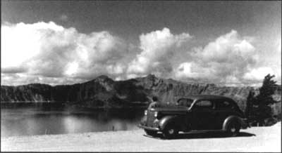
Throughout the summer a number of visitors come to the information desk at Park Headquarters asking about the best place to see Crater Lake. These people have convinced themselves that they have only an hour or so to spare in the park, and then want to be on their way to somewhere else. I routinely dodge this type of query, if only because they have not yet seen the lake. This makes it impossible to communicate where around the rim a person could best appreciate that wonderful combination of color, geological features, and subalpine vegetation which has prompted more than one person to describe Crater Lake as the most beautiful thing they have ever seen in nature.
For those who are so short on time, and wish to limit their experience to one which involves little or no contemplation, any lake viewpoint between Park Headquarters and the North Junction will do. Motorists soon find that more than one stopping point allows them to stay in their vehicle and still see Crater Lake. They will, however, find it difficult to appreciate their surroundings without a good guidebook at the very least.
The Mazamas, a mountaineering club based in Portland, published the first booklet aimed at enhancing visitor enjoyment of Crater Lake in 1897. It had limited availability, so the government began to print pamphlets and maps with some explanation of the park’s geology. These devices still fell short, it seemed, of allowing the non-scientist to fully comprehend what lay before them. Trained naturalists began lecturing and guiding the public in Crater Lake National Park during the summer of 1926, but the question of how to best convey the park story remained. After some study, park officials decided to focus most of their educational program at Rim Village because of its proximity to what had long been the most popular viewpoint at Crater Lake.
Visitor near Victor View in the late 1930s.
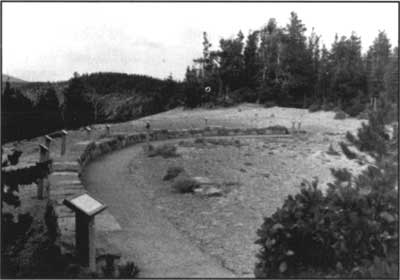
Named in honor of a historian who visited the lake in 1872, Victor Rock appears to be precariously perched some 900 feet above the water. The Sinnott Memorial was situated over this viewpoint in 1930, so that naturalists might give a brief orientation talk from an open-air parapet on a regular basis throughout the summer. Certainly no classroom, nor any other facility situated away from the rim, can equal the Sinnott Memorial as a venue to both see and hear about Crater Lake for the first time. It continues to function as an observation station aimed at enticing visitors to explore the park, in the hope that what they experience here will fuel an ongoing fascination with the forces which continue to shape the earth.
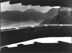 The sinnott memorial’s parapet as it appeared iin 1933. NPS photo by George Grant. |
To broaden the introduction given by naturalists in the Sinnott Memorial, park officials initiated an educational boat tour of Crater Lake in 1931. That year they also began a project which was to widen and realign Rim Drive. In addition to making the road safer, designers focused on showing motorists many important park features. In order to accomplish both goals, masonry walls and the resulting series of observation stations were built to blend into their surroundings. Just as the Sinnott Memorial is virtually invisible from the surface of Crater Lake, the Rim Drive is intended to facilitate contemplation of the lake, cliffs, and forest by minimizing road scars that can be seen at a distance. Far from being the cookie cutter pull outs which often characterize modern road design, each of the observation stations was intended to help visitors see the park in different ways — as anyone who has been to such divergent stops as Discovery Point, Grotto Cove, Skell Head, and Kerr Notch will attest.
The East Rim Drive in particular remains much as its designers left it, while also being largely free of the noise and crowds which often dominate the through route from Rim Village to the North Junction. With the notable exception of the Cleetwood Cove parking area (where people have gathered almost every summer day since 1960 for hikes down to the lake and a boat tour), visitors who pause along this 24 mile road segment should have few distractions — especially if they are inclined to walk even a short distance. In nominating a favorite stop along this stretch of road, my choice is based on the following subjective combination of factors. These include the predominance of quiet, an opportunity to hike, the attractive contrast of subalpine vegetation with open slopes, authentic examples of stone masonry from the 1930s (original work can be identified from mortar joints which feature some lichen growing on them), and, of course, the sublime drama of Crater Lake.
With those criteria in mind, my choice is a place known as Victor View. It does not appear on some maps, though the name became official in 1945. The park superintendent at that time found very few people who could identify the rock named for Mrs. Victor, even though thousands of visitors came to the Sinnott Memorial each summer. Victor View is an observation station located between Cloud Cap and Kerr Notch, but has not been signed as such. Neither is the trail which leads from pavement to Sentinel Rock, where people who are afraid of heights or inclined toward vertigo should not venture. A stand of mountain hemlock (Tsuga mertensiana) act as a screen so that many visitors stopping at the road overlook do not notice the trail, but it can be seen immediately opposite the masonry wall. After winding through the trees, this path emerges on a spine composed largely of pumice “gravel” so that it is roughly a hundred yards to the terminus at Sentinel Rock.
Grotto Cove Overlook in 1968. NPS photo by K.R. Cranson
Such a vantage point certainly fills the few human visitors it receives with a sense of how privileged they are to stand where only the birds seem to light. A number of other places around the rim (Dutton Cliff, Dyar Rock, Hillman Peak, to name a few) may equal Victor View depending on what a person wishes to experience in conjunction with Crater Lake. Judgments attached to any of these places are, of course, relative to the person involved but any of them can render the urgency of reaching other destinations outside the park meaningless for a couple of hours. It should come as no surprise. therefore, that if I have to respond to questions about the “best” place to see Crater Lake, the answer will be “as far from your car as possible.”
Steve Mark has worked as park historian at Crater Lake and Oregon Caves since 1988.
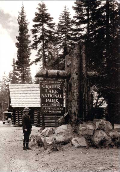
Superintendent Dave Canfield and a new entrance sign, 1936. NPS photo by George Grant.
Other pages in this section