
Pumice Fields and a Sense of Landscape Wonder
Coniferous forest which surrounds the caldera embracing Crater Lake is broken by curious openings called pumice fields, especially around the rim. Many of the pumice fields are spacious and provide grand vistas of the Cascade Range, but they are also windows into the landscape’s past. The climactic eruption 7,700 years ago instantly erased biota firmly rooted upon the slopes of ancient Mount Mazama. Pioneering lifeforms of the pre-Mazama biota surviving in neighboring refugia eventually migrated upslope and colonized suitable habitats, but the eruption’s power restricted the availability of these habitats.
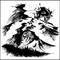 Hypothesized appearance of Mazama at the beginning of its climactic eruption. Drawing by Walter Rives, 1948. |
Despite dry and sunny summer weather enjoyed by human visitors, the growing season of the pumice fields is abbreviated by extremes of temperature and moisture. Topographic features create frost pockets in swales, along lower slopes, and in crater depressions atop cinder cones. This allows snow to drift and accumulate, so that it sometimes persists through the growing season. Upland habitats, especially those with rocky outcrops, are devoid of snowpack early in the summer but are subject to dry winds — as are south- and west-facing slopes. Surface temperatures are normally intensified by high summer sun, but reduced by reflective qualities of the light-colored pumice. Air temperatures near the ground may change significantly over a 24 hour period, with a chance for frost even in summer. Pumice soils, having been pulverized by volcanic eruption, are very porous. This allows large quantities of water to infiltrate and percolate deeply, but largely robs the surface of moisture.
The volcanic landscape of Mount Mazama represents a mosaic of habitat types, and the pumice fields have resisted encroachment by individual trees and shrubs for centuries. The tree species best suited for pioneering this seemingly inhospitable habitat appears to be whitebark pine (Pinus albicaulis). This species even assumes the role of pioneer in the fractured obsidian flow of Paulina Peak at Newberry Caldera southeast of Bend. Similarly, much of the caldera’s rim edge around Crater Lake is fringed with whitebark pine as though planted in a row single file. It is this edge habitat, which is swept free of deep snow, that harbors a longer growing season than adjacent pumice fields extending downslope from the rim. This is also where the Clark’s nutcracker (Nucifraga columbiana) caches seeds from whitebark pines, thereby insuring some regeneration.
 There are some “tree islands” within the pumice fields generally featuring a single whitebark pine perhaps established a few centuries earlier. These trees may be situated on churned soil where a Mazama pocket gopher, Thomoys mazama, created a mound within the shelter of a rock. During the growth of a “mother tree,” local microclimate changes to favor the establishment of herbaceous and shrub species in addition to subalpine fir (Abies lasiocarpa) or mountain hemlock (Tsuga mertensiana) sheltered by the whitebark’s canopy. It is common to find that the original “mother tree” has died, but still is surrounded by younger trees which prevent the snag from falling. In an environment marked by harsh growing conditions, chances for survival are enhanced by development of individual saplings in aggregations or clumps with grafted roots.1
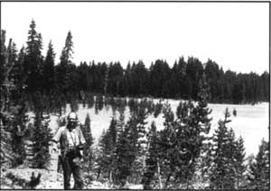
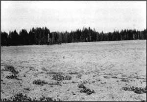
A pumice field near Union Peak in 1936 (top) and forty years later (bottom). Photos by Homer Marion, 1936 (top) and Ron Mastrogiuseppe (bottom).
Given the potential number of species available for colonizing pumice fields, however, it is a mystery why additional lifeforms have not yet invaded. Each year, and especially when there is a prolific seed cone crop, the pumice fields are recipients of myriad seeds and propagules. Yet this annual “rain” of seed seems unable to bring additional numbers of species. The total number of plant species found within the Pumice Desert, for example, is only fourteen.2 Other pumice fields are likely similar in species diversity. When compared to the park total of some 700, this gives meaning to the term depauperate flora — one lacking in species richness.
The shape of pumice fields can change over time when surrounding forest borders (usually dominated by lodgepole pine, Pinus contorta) respond to favorable conditions. Conifer encroachment, as documented in repeat photography, began during the drought episode of the 1930s. During that decade growing seasons expanded by roughly one month as the result of warmer temperatures and reduced snowpack.3 This pattern of encroachment is not unique to the Crater Lake region, having been observed throughout the subalpine zone of the Cascade Range. Perhaps similar phenomena will be kickstarted by the years of drought (which extended from 1976-77 until the early 1990s) since these changes are believed to be driven by climatic, rather than climactic,events.
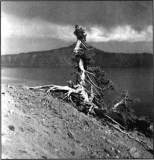
Whitebark pine on the rim of Crater Lake.
Notes
1 Fire seems to have little effect on this habitat. Lightning may strike individual stems within the tree islands, but fuels beyond them are too scant to carry a surface fire for any distance. It should not be a surprise, then, that evidence of historic fire is almost always absent from pumice fields.
2 See Ruth Monical and Stephen P. Cross. Mammals of the Pumice Desert, Nature Notes from Crater Lake 23 (1992). pp. 17-18.
3 The exception to this interpretation was the winter of 1932-33, when a record of more than 700 inches occurred.
Ron Mastrogiuseppe is a forest ecologist who has monitored pumice fields and other phenomena in Crater Lake National Park since 1964.
The True Firs of Crater Lake National Park: A Closer Look
Four of the nine species of true fir (Abies) in the United States are native to Crater Lake National Park. Of these, two have been incorrectly identified by some foresters and botanists. There has been no such problem for two other Crater Lake firs: subalpine fir(A. lasiocarpa), and Pacific silver fir (A. amabilis). The problem, rather, has been with trees called “white fir” and “Shasta red fir.”
White fir
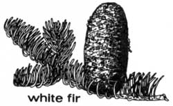
The term “white fir” has been broadly used to include two identified varieties; Rocky Mountain (“typical”) white fir (A. concolor v. concolor), and the Sierran white fir (A. concolor v. lowiana). The Crater Lake tree is Sierran white fir. This is the park’s lower elevation fir, best seen and appreciated from Highway 62 viewpoints overlooking Castle Creek Canyon toward Medford and along Highway 62 in the “panhandle” toward Klamath Falls.
As is the case along the Cascade Range from central Oregon to the Siskiyous, west slope white firs (especially at lower elevations) integrate with grand fir (A. grandis).Some white firs, just inside the park’s western boundary, show this trend, especially by the coloring of outer bark texture. Outer bark on grand fir, as seen in cross section, has alternating layers of dark brown and violet, while that of both varieties of white fir have softer corky layers of brown and tan. Crown formation, seed cone, and leaf characters are used for separating the two white fir varieties (see Table I).
This species of fir at Crater Lake is best identified as “Sierran” white fir, since some observers may appreciate the varietal distinctions. The Rocky Mountain variety is popularly cultivated as an ornamental throughout much of the northern United States, and is recognized initially by its silvery-blue crown color which resembles that of blue spruce (Picea pungens).
The natural distribution of Rocky Mountain white fir is from the Wasatch and Uinta Mountains south and eastward through Utah, Colorado, New Mexico, Arizona, eastern Nevada, southeastern California and northern Mexico. Sierran white fir is native to east-central and southwestern Oregon, western Nevada. and in California south to the Tehachapi and San Bernardino Mountains where the two varieties join their ranges and blend morphologically.
Table I
The Basic Differences
| Rocky Mountain White Fir | Sierran White Fir | |
|---|---|---|
| Needles |
|
|
| Cone Bracts |
|
|
| Crown Formation |
|
|
Red Fir
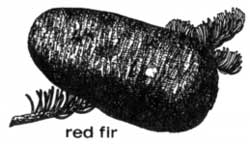
The terms “Shasta red fir” or “Shasta fir” have been used to identify a species of Abies which occurs at higher elevation in the park ever since 1939, when botanist Elmer Applegate wrote that he did not recognize noble fir (A. procera) in the southern Oregon Cascades. His opinion has since had wide influence with foresters, so that the term “Shasta fir” has been used in numerous publications. They have continued to list both Shasta red fir (A. magnifica v. shastensis) and “typical” or “California” red fir (A. magnifica v. magnifica) in southern Oregon.
The type-locality for the variety shastensis is Mount Shasta; for var. magnifica it is the south central Sierra Nevada. Despite the widely-held perception that “typical” red fir is native to Oregon, this variety has not been verified by specimen documentation north of Mount Lassen, where both red fir varieties occur together. The two red fir varieties are morphologically separated by a key seed cone characteristic, that of cone bract length (see Table II). Variety shastensis has bracts (with reduced points) which are exserted beyond the cone scale. In var. magnifica the bracts are shorter, becoming totally hidden within the closed seed cones.
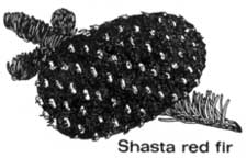
Some foresters have reasoned that “Shasta fir” is the product of introgression between “typical” red fir with hidden bracts, and noble fir with conspicuously-bracted cones. They have established hypothetical red fir boundaries for such “Shasta fir,” with the northern boundary at 44 degrees North Latitude (McKenzie Pass) and the southern boundary in the vicinity of the 41st parallel in northwestern California. This creates a “transition zone” for the “Shasta fir” population, whereby Crater Lake National Park falls inside this zone.
It should be emphasized that noble fir and red fir are closely related, and that studies show them to be highly variable relative to species distinctions based on chemistry, phenology, and morphology. The smooth “Shasta fir” transition zone becomes geographically problematic when the exclusive occurrence of bracted “Shasta” red fir at the southern end of the “typical”‘ red fir habitat is taken into account.
A number of botanists, meanwhile, have recognized noble fir as extending south into northwestern California. The most clearly defined morphological division between noble fir and red fir populations seems to be the Klamath River Basin. The extent of this division (through leaves, cones, progeny development and seedling cotyledon count), is unmatched at any other location in the Cascade Range or Sierra Nevada, greatly exceeding any differences apparent at the “Shasta fir transition zone” boundaries. Although this “Klamath division” follows the southwesterly course of the river to the coast, noble fir has been verified in the Klamath Mountains south of the river. Its absolute southern limit is not yet established, though noble fir-like cones have been collected as far south as Mendocino County (see Table II).
Table II
Noble Fir and Red Fir
Common Characteristics
Leaves flattened four-angle cross-section (rhomboid), blunt or acute, bent at base like a “hockey-stick,” stomatiferous above and below.
Cones large, upright, cylindrical or tapered; light olive-green to dark purplish-brown.
Mature outer bark interior layers of dark brown and deep violet.
| Noble Fir | Red Fir | |
|---|---|---|
| Leaves |
|
|
| Cones |
|
|
| Bark |
|
|
Noble fir and Crater Lake
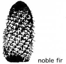
There is a compelling argument for applying what has been learned about the true geographic range of noble fir within Crater Lake National Park. Even though the bark of some trees in the park resembles the red firs of the Lassen Shasta region, and occasional phenotypes noble fir have cones with rather short Shasta-like bracts, the trees in the Crater Lake vicinity should be interpreted as noble fir. My argument, in summary form, is as follows:
- The established botanical keys for noble fir and red fir identify the common fir north of the Klamath River as noble fir, or at least as a morphological variant of noble fir.
- The name “Shasta red fir” has been borrowed from its original application to the short-bracted red firs of California, and given blanket application to firs in Oregon south of McKenzie Pass.
- The hypothesis that “Shasta fir” in southern Oregon is a “hybrid swarm” or introgressed “transition population” has been weakened by a study which found no evidence of more genetic variability in the so called transition zone than elsewhere.
- Noble fir and red fir are both variable in cone and leaf morphology, and in oleoresin properties (noble fir to a greater degree than red fir). Variability in noble fir is more noticeable in southern Oregon, but variability north of McKenzie Pass has been calibrated, with some of the most extensive differences in resins found near the Columbia River.
- Early botanists named the common southern Oregon species noble fir. It was only later that the awareness of occasional cone and leaf variations suggested relationship to the California firs. This resulted in polarized opinions that have fueled a long-term controversy. Subsequent interpretation of “typical”‘ or “pure” noble fir has produced an arbitrary “north-of-the-McKenzie-theory” which holds that the firs south of that point should not be identified as A. procera. The primary authors of this hypothesis, however, have recently concluded that the classic taxonomic characteristics (cone and leaf morphology) of southern Oregon populations suggested a close relationship to noble fir.
Recognition of the natural variations in noble fir will restore the term “Shasta fir” to its area of origin and intended application. The Lassen-Shasta region has trees with thicker, rougher and more reddish bark than those in southern Oregon. These firs also have larger cones with only partially-exserted or completely hidden bracts, as well as foliage that is anatomically distinguishable from noble fir.

Cones are one of the most commonly used ways to identify trees. The Douglas-fir is not a true fir, as its hyphenated name indicates. Drawing by Hugh Hayes in Trees to Know in Oregon Corvallis: Oregon State University Extension Service, 1995.
References
S.F. Arno and R. P. Hammerly, Northwest Trees. Seattle: The Mountaineers, 1977.
W.B. Critchfield. Hybridization of the California Firs. Forest Science 34:1, 1988, pp. 139-151.
E.L. Parker, The Geographic Overlap of Noble and Red Fir. Forest Science 9:20, 1963, pp. 207-216.
F.C. Sorensen et al., Geographic Variation in Growth and Phenology of Seedlings of theAbies procera – A. magnifica Complex. Forest Ecology and Management 36. 1989, pp. 205-232.
Gene Parker made numerous contributions to the study of botany in southwestern Oregon before his death in 1996. He will be remembered for specializing in true firs, an interest which became the catalyst for several important discoveries in Crater Lake National Park.
Drawings courtesy of U.S. Forest Service, Klamath National Forest.
Clearing the Way
There are still some people who are surprised to learn that Crater Lake can be seen at any time of the year. Much of this misperception is due to visitors focusing on the North Entrance and associating its closure each year with the park being shut for the winter.
Since opening the North Entrance each year signifies the start of peak visitation, the casual observer might wonder why virtually all park facilities are situated on the south side of the caldera. One reason is that very little surface water exists on the north side of Crater Lake despite the prodigious snowfall. Efforts to develop a water supply were frustrated in the 1960s when contractors drilled wells at Cleetwood Cove and the North Entrance but netted nothing but air. A steep ascent from Pumice Desert to the North Junction, coupled with the difficulties of fighting prevailing wind from the southwest, make consistent plowing of the north road exceedingly difficult. Clearing the route leading to Rim Village from Annie Spring and Highway 62 is, by comparison, much easier.
Most visitors come to Crater Lake only during the summer months and are oblivious to the complexities associated with snow removal. Many of them see only a few outward manifestations of winter, such as snow tunnels attached to buildings at Park Headquarters. The size and number of plows operated by park crews are usually out of sight by this time, along with the multitude of snow poles which line certain roads for most of the year.
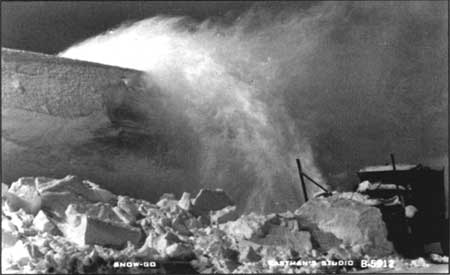
Rotary snow plow used in the late 1930s.
Prior to 1930, when the first rotary snow plow arrived at Crater Lake, opening any road to the rim each spring required a large crew armed with shovels. They began by chopping through most of the previous winter’s snowpack to reach the road surface, which was often under many feet of snow even in June. Warm weather and the high sun angle of late spring might eventually allow for cars to reach Rim Village in early July, but the park’s operating season was effectively reduced to three months or less. With machines which could throw snow away from the road surface, and then above surrounding banks of ten feet or more, it became possible to keep a few roads open throughout the year.
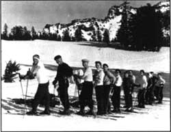 Skiers at Rim Village in 1957. NPS photo by Raymond K. Rundell. |
As might be expected, rotary snow plows gave winter use in the park a decided shot in the arm. Such use had amounted to virtually nil before that time except for the occasional venturesome skier coming from Fort Klamath, the closest permanent settlement. Improving economic conditions by the late 1930s gave rise to increased travel and an associated demand for winter sports. No permanent facilities for downhill skiing were ever constructed, but Crater Lake was listed as Oregon’s second biggest winter sports area (behind Mount Hood) in 1940. That status has to be understood in the context that most leases for development of areas on Forest Service land, such as on Mount Bachelor near Bend, were not issued until the explosion in leisure travel had occurred after World War II.
Wartime restrictions on travel meant closure for Crater Lake National Park from 1942 to 1945. When the park reopened, there was uncertainty concerning whether to provide downhill skiing facilities. National Park Service planners studied several locations such as Applegate Peak, Arant Point, and the west side of Munson Ridge in 1948, but concluded that any new development aimed at downhill skiing carried far more long-term costs than benefits. They recognized, however, that existing use (visitors wanting to see the lake in winter, as well as cross country skiing and snowshoeing) as justification for keeping the park open all year round. This has occurred over the past 50 years by plowing snow as it accumulated on roughly 25 miles of park roads.
Those visitors and employees who utilize the access provided by the snow plows have the opportunity to enjoy the beauty brought to the rim of Crater Lake by each seasonal change. During the long winter, the snow accentuates glassy blue or steel grey of Crater Lake depending on clear or cloudy conditions. Visitors often note the snowdrifts, especially where the wind puts vast deposits in some places (upwards of 60 feet at the Watchman) but scours bare spots in others.
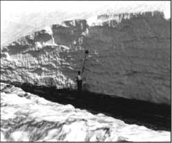 Roadside snow depth. |
As the snowpack begins to recede in May, the patches of bare ground slowly widen and eventually become host to a variety of plants and animals. Flower displays herald the arrival of spring sometime in late June, though the peak bloom will not be reached until the first week of August. At that time motorists and hikers alike are quick to note bright colors and ask for the names of certain wildflowers.
The summer heat usually melts even the most persistent patches of snow by mid August so that all roads and trails in the park are open. This is when the ubiquitous Newberry knotweed(Polygonum newberryi) turns from green to red in the vast pumice fields along the rim drive. Fortunate visitors may also find that yellow-bellied marmots (Marmota flaviventris) and pikas (Ochotona princeps) show themselves on talus slopes or even near the road.
Sometime during the first half of September, the first crisp air indicates the onset of autumn. By the end of the month, the leaves of shrubs such as mountain ash (Sorbus sitchensis) have turned color in a matter of only several days. They provide memorable splashes of red and yellow to those visitors lucky enough to be in the park at that time, and perhaps portend a few weeks of Indian Summer. On October 20th, however, there is a 50 percent chance of the first significant snowfall–one which will close most roads and the North Entrance. When that storm arrives, it heralds the onset of winter and the prospect of nearly nine months with snow on the ground. This is also when the snow plows return to clear the way to the rim of Crater Lake.
Steve Mark has worked as park historian at Crater Lake and Oregon Caves since 1988.
A Furry Encounter of the Close Kind
It was an unusually quiet morning. Most of the previous winter’s snowpack had melted by the time summer began to reach its mid point. My family slept as I descended the stairs of a stone house at Park Headquarters to begin preparing for another day of assisting visitors. Little did I realize my first assistance that day would be to a rarely seen forest animal who had shown up, unannounced, for breakfast. As my foot touched the bare floor, a shiver went through my spine when a scrambling sound came from the kitchen. I realized then that I was not alone.
Upon tip toeing into the kitchen, I spotted a streaking ball of fur clamber up the kitchen cabinets. It headed for the early morning light of the window above the sink, apparently expecting to gain its freedom. The glass, however, stopped the creature’s hurried retreat. After realizing there was no escape, the animal then turned to face me. At that moment I saw its huge eyes, ones I will never forget. As I looked at the frightened animal, I recognized a frightened Cascade flying squirrel (Glaucomys sabrinus).Thankfully, the tingling in my spine quieted once I knew the source of those strange early morning noises.
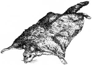 Drawing by Larry Eifert, The Distinctive Qualities of Redwoods, 1993, p. 37. |
I now wondered how the squirrel gained entry to our house. This nocturnal explorer, I then surmised, fell down our chimney while swinging from the bough of an overhanging mountain hemlock (Tsuga mertensiana). As it cowered on the kitchen window sill, I examined the squirrel. Brownish-gray fir, somewhat wispy, covered a diminutive body. It had a short, rounded nose and huge, unblinking eyes. The latter were obviously “better to see you with, my dear” at night.
Word of our furry visitor spread quickly among park staff, resulting in a steady stream of visitors parading through our house for the greater part of the day, all wanting to take a peek at one of nature’s most secretive and elusive creatures. The squirrel never seemed to blink all day, nor show any sign of sleeping. It never attempted to leave the safety of its narrow perch near the window. With darkness approaching, however, it was time to return the squirrel to the old growth forest. As we held the door open, the furry bundle began to stir and was soon scampering into the darkness.
That was 1973…
Almost 25 years later, while driving to Rim Village in March, I spotted what looked like a tiny Russian winter fur cap with ear flap lying in the middle of the road. As I pulled to a stop to pick up what I thought was a discarded piece of protective clothing about a half mile above Park Headquarters, I realized it was not at all what I had imagined. The brownish-gray “hat” was quivering and its “flaps” were rythmatically moving in and out. It was then I realized that I had found some type of small squirrel hunkered down on the packed snow. A bushy tail was thrust full length under its body and extended enough to cover a tiny face. What I witnessed, of course, amounted to survival behavior designed to keep the animal from freezing. As I hurriedly climbed out of my vehicle to take a photograph, the squirrel’s tail fell away from its face. This motion revealed its eyes, the same ones I remembered seeing in 1973!
As I approached the little ball of quivering fur, it suddenly darted for the top of my rear tire. This provided a nice level for a photo or two, but I wondered why it was not hibernating at this time of year. By gently rocking my vehicle back and forth after taking some pictures, I was able to frighten the squirrel from my tire and off it ran. As the flying squirrel was lost from view, I could only wonder about the hardships it faced during the next three months of winter. As I contemplated the danger posed by Pacific marten (Martes caurina) who prowl daily for small mammals, I could only hope that the flying squirrel might find the relative safety of a stone house — just as his ancestor did so long ago…
Larry Smith teaches school in Jacksonville, Oregon, and volunteers with the Friends of Crater Lake National Park. He worked as a seasonal employee in the park between 1961 and 1985.
Other pages in this section