

Volume 31, 2000
All material courtesy of the National Park Service. These publications can also be found at http://npshistory.com/
Nature Notes is produced by the National Park Service. © 2000
Not Your Average Visitor
Some months ago a story about Theodore Roosevelt began circulating in the local area. According to sources in Klamath Falls, Roosevelt signed legislation establishing Crater Lake National Park on May 22, 1902 in the lobby of the Baldwin Hotel. His published correspondence, however, showed the President to have been either in the White House or New York City during that week. Other problems plagued the story, too. One concerned the lack of contemporary publicity accompanying such a momentous visit, especially when Roosevelt’s western swing in 1903 was widely covered by local and regional news accounts. Access presented another difficulty, since passenger rail lines did not reach Klamath Falls until several years after the park’s establishment.
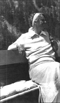
Not to be deterred, some residents pointed to a photo taken within the first decade of the park’s establishment, It showed a rotund man reputed to be Roosevelt and three companions sitting along the edge of the caldera with Garfield Peak as a backdrop. Their belief about the photo was publicized in a local newspaper article once doubt had been cast on the original story about signing legislation at the Baldwin Hotel. When the Associated Press gave the photo national publicity, representatives of the Theodore Roosevelt Association in New York challenged the notion about the central figure being Roosevelt and cited a number of reasons based on his known physical characteristics.
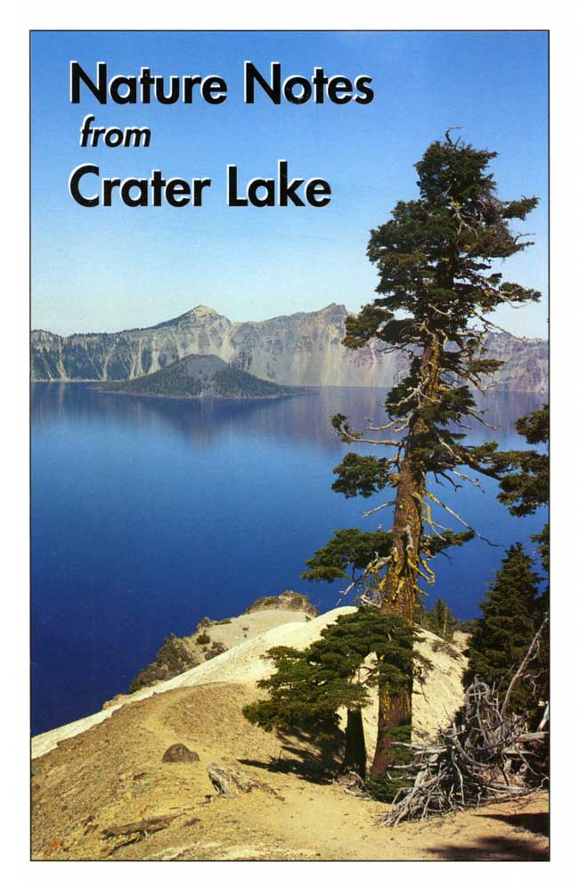
 Eleanor Roosevelt enjoying a boat tour, 1934. NPS photo, Crater Lake Museum and Archives Collection. |
As good as any story about TR sounds at first blush, the only evidence for any Roosevelt to have visited Crater Lake comes from 1934. On the evening of July 31 Eleanor Roosevelt came to the park unannounced and stayed overnight in the Crater Lake Lodge. She wanted to enjoy a naturalist-led boat tour on Crater Lake the following day and did so. Her visit has so far constituted the only occasion when the Chief Executive or his wife visited the park while in office. Since that time, the only ex-President and First Lady to arrive at Crater Lake were Jimmy and Rosalyn Carter. They made a brief visit on a sunny September day in 1991.
It is worth noting that the Carters, not Mrs. Roosevelt, corresponded more closely to the average park visitor’s profile. In this respect, Mr. and Mrs. Carter came as a single “family” where two people (not counting the Secret Service agents) comprise the most common group of visitors. Single families far outnumber the visitors traveling alone or larger groups such as bus tours. Like the majority of summer visitors, Mr. and Mrs. Carter had never seen Crater Lake previously and their midday stop in the park lasted less than four hours. They, like so many other people who come here, did not see it as a destination. Mr. and Mrs. Carter visited Crater Lake en route to the North Umpqua River, where they wanted to go fishing.
Most visitors do not encounter National Park Service staff during the course of their stay, but the Carters found employees willing to assist them because they made the effort to stop at Park Headquarters before proceeding to the rim. The ex-President and his wife even heard an interpretive talk, thereby joining the minority of the park’s half million visitors each year who experience a portion of our educational program. Only one in five visitors find their way to a contact station such as the Kiser Studio in Rim Village or the Steel Information Center at Park Headquarters, yet those who do receive assistance on how to better enjoy their time in the park. These contact stations contain an impressive array of items offered for sale by the Crater Lake Natural History Association, and among them are fewer than 500 hundred copies of this publication. So few are printed because the average visitor chooses not to take a boat tour, hike a trail, nor even travel the full 33 miles of Rim Drive. Gentle reader, Nature Notes from Crater Lake is produced in the hope that you might take time to experience more of what this park has to offer.
“Theodore Roosevelt” and companions, date unknown. Photo courtesy Southern Oregon Historical Society, Medford.
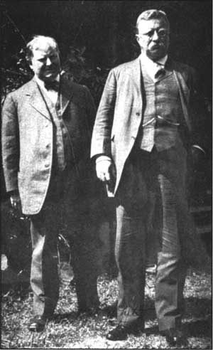
The real Theodore Roosevelt in 1902. Photo courtesy Southern Oregon Historical Society, Medford.
Not So Static a Scene
The famous pioneer artist and photographer Peter Britt first captured the unusual beauty of Crater Lake on a glass plate negative in 1874. Even in black and white, the magnificence of the scenery was clearly visible. Some 126 years later you can walk to the spot where Britt took his photographs and discover that the view of the lake has not noticeably changed. One might ask how it is possible that this deepest lake in the United States, the result of one of the largest volcanic eruptions in North America, has found some special state of tranquility?
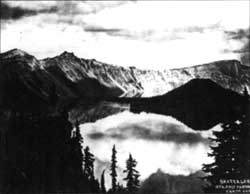 Peter Britt took this photo of Crater Lake in 1874. Southern Oregon Historical Society photo, Medford. |
Crater Lake’s physical setting is certainly unusual. The lake sits within a basin called a caldera, created when Mount Mazama exploded and collapsed here some 7,700 years ago. Within a few centuries, a lake appeared with a depth of nearly 2,000 feet. At the present time, the total volume of water located beneath its surface comes close to 4.5 trillion gallons. That is enough lake water to provide 750 gallons to each man, woman, and child on earth. Since the lake occupies a caldera, the surface area is restricted to about 21 square miles, with the widest point being a little more than 6 miles. Towering rocky walls loom above the entire shoreline with some rising to nearly 2,000 feet, These slopes stop the flow of streams originating from outside the caldera.
Given the physical restrictions nature has imposed upon this lake, how is it that this apparently stagnant pool of water can remain so blue and clear for so long? What prevents the lake from becoming salty to the extreme? To try to answer these fundamental questions about Crater Lake, scientists began examining the physical and chemical properties of Crater Lake as early as 1883. One survey party in 1886, for instance, made the first successful soundings of the lake and recorded depths ranging between 93 and 2,008 feet. Research continues to the present, not only to refine past data, but is also aimed at tackling as yet unanswered questions.
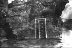 An early attempt to gauge changes in lake level. Photo by J.S. Diller, U.S. Geological Survey, 1901. |
Warm and sunny summer days at Crater Lake are too soon followed by months of cool and wet weather. Park Headquarters, with an elevation 6,500 feet above mean sea level, usually receives 533 inches of snow during a weather year (July though June). This precipitation annually provides the lake, on average, with 34 billion gallons of water. Some 27 billion gallons falls directly onto the surface of the lake, with the remaining 7 billion gallons entering as run-off from inside the caldera. Some minerals are introduced to the water as a result of this inflow, but the concentrations are minor. The principal sources for the minerals dissolved in the lake are the dozens of springs located within the caldera. When compared to other volcanic lakes, however, these sources are very limited. Within every gallon of water from Crater Lake, for example, there is about 1/100th of an ounce of dissolved salt. Public drinking water, by comparison, usually has considerably more. The mineral content would be much greater were the rock walls surrounding the lake absent and if creeks or streams originating from outside the caldera were permitted to discharge into the lake their load of dissolved solids.
A major reason why Crater Lake appears static is that the lake level seems fixed. In actual fact, however, the level can rise and fall as much as 16 feet with varying snowfall amounts from year to year. What happens to the snow that falls into the lake each winter? If the lake level changes only slightly from year to year water must be exiting in some fashion, Both evaporation and seepage are responsible; water evaporates at the lake surface, but exactly where water leaks away is still a mystery. There could be several places where seepage occurs, since the caldera is composed of fractured lava flows, unconsolidated avalanche debris, and glacial till. One likely spot for seepage is the north wall of the caldera where a glacial valley disappears beneath the shoreline, The fact that the lake level is no higher than this major discontinuity has led some observers to believe that here is a major hole in the side of the caldera, analogous to a leaky rain barrow.
To keep the lake level static, 17 billion gallons of water must seep out each year. We know this is the case because when Crater Lake last froze over (in 1949), the lake level continued to drop by a rate that, over a year’s time, would add up to this amount. Evaporation removes only fresh water, but seepage removes the denser, salty water deep in the water column. Scientists figure that a drop of water can expect to remain the lake for at least 150 years before it either seeps out or evaporates away. A new lake is thus re-created every few centuries. This is another reason why Crater Lake remains fresh and pure.
The surface area of Crater Lake is limited, but wind from above still pushes the water around to produce ripples and waves. Under stormy conditions, the waves grow large enough to produce a display of foamy tops or white caps. Water is mostly pushed eastward according to the prevailing wind direction, In winter, when the water is uniformly cold, surface winds can push large volumes of water downward into the lake. Descending water currents transport large amounts of dissolved oxygen absorbed at the surface. For this reason, the upper 650 feet of lake water is well oxygenated. The vertical mixing of water in such a deep lake is, however, normally restricted. The upper layers are usually warmer and less dense than the colder water beneath. Some deep mixing may occur in January when winds are the strongest and when the vertical temperature structure of the lake is most uniform. Even then, the water at the lake basin is only incompletely exchanged with the oxygen-rich surface water and it appears that several winters are necessary for its complete replacement. Without such exchanges with surface water, decomposing organic materials on the bottom would eventually use up all available oxygen.
Another reason why the vertical movement of lake water is important relates to upwelling. As descending plumbs of oxygen-rich water reach the bottom, they displace upward some nutrient-rich bottom water. In this way, organisms occupying the upper part of the lake receive necessary chemical enrichment. There are 157 species of microscopic plants, called phytoplankton, that drift in the upper 600 feet of lake water. These plants are at the bottom of the lake’s food chain and are preyed upon by a variety of animals, including the zooplankton. Ninety percent of the nitrogen needed by aquatic organisms must come from upwelling, nutrient-rich bottom water. Since the annual turnover of lake is incomplete, it is not yet known how this limited circulation pattern affects the overall biology or clarity of the lake from year to year.
 Winters with a higher than average snowfall will produce a corresponding rise in lake level. Photo courtesy of Wayne and Jean Howe, March 1947. |
The clarity of water in Crater Lake also varies seasonally and annually. In summer, as the surface of the lake heats, the less dense warm upper layers do not mix downward very well into the cooler, denser waters below. Floating particles remain in suspension until a strong wind forces the water to mechanically overturn. Under warm surface conditions, the clarity of Crater Lake usually decreases. No two years, however, are identical. There have been summers when clarity dropped for extended periods of time. Could it be that a successful winter turnover has redistributed large amounts of nutrient from far below the lake’s surface? This might raise the concentration of phytoplankton in the water column above what is normally observed and contribute to the drop in clarity. Or could it be that an unusually large population of fish has consumed all the zooplankton? Since the zooplankton normally preys upon the phytoplankton, the phytoplankton populations might then soar, High concentrations of phytoplankton may thus restrict the lake’s clarity.
It is worth remembering that Crater Lake is never truly the same from day to day. The lake is constantly in flux as water both enters and leaves the caldera, Wind currents move over the surface and push the water in several directions, yet from the rim this is impossible to discern except on very windy days. From this distance, the lake generally appears static. Given enough time, however, more obvious changes will occur. No lake can last forever, especially a volcanic one. The fires beneath Mount Mazama will warm some day and increased hydrothermal activity will alter the chemistry of Crater Lake, so that the clear blue lake will be no more. What we see as static is an illusion created by a faulty sense of time.
Tom McDonough teaches at Chemeketa Community College in Salem, Oregon, while also pursuing his scientific interests each summer at Crater Lake.
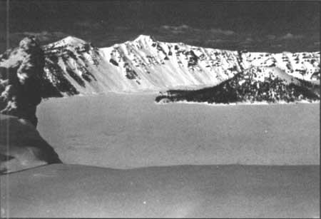
Crater lake frozen over in 1949. Taken from same site as Britt’s photo of 1874. NPS photo, January 1949.
Studying the Denizens of Tomsandi
In the summer of 1999 I had the opportunity to thoroughly explore large whitebark pine stands in the vicinity of Mount Scott. Aiming my map and compass toward random coordinates led me through drainages, up slopes, and into tree stands that I would have never seen by hiking the trails. The fieldwork for my senior capstone project at Southern Oregon University involved establishing and taking data in permanent plots for monitoring whitebark pine health. Specifically, I was looking for a tree disease called white pine blister rust. Blister rust is caused by the fungus Cronartium ribicola which invades the bark and stem tissues of five-needle pines including whitebark pine (Pinus albicaulis), sugar pine (P. lambertiana), and western white pine (P. monticola).Eventually the fungus girdles and kills infected branches and stems and is responsible for the decline of white pines in British Columbia and throughout the United States.
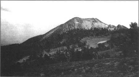
Mount Scott with whitebark pines in the foreground. Parkhurst family photo, ca. 1916.
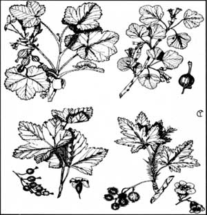 Common species of native currants (Ribes) that occur in Crater Lake National Park. Drawings by Charles F. Yocum in Shrubs of Crater Lake, (Crater Lake Natural History Association, 1964), p. 12. |
In the late 1800’s expanded commercial cutting of white pines increased the demand for seedlings to be planted, but American nurseries could not profitably meet this demand. A high tariff, which had previously limited importation, was removed and large numbers of seedlings were imported from Europe between 1907 and 1909. Species native to North America were grown in the European nurseries and often shipped back infected with blister rust. The fungus is native to Asia and most North American white pine species are highly susceptible even though some natural genetic resistance exists. Blister rust was first found on the East Coast in eastern white pines as early as 1909. It spread quickly because infected seedlings from Germany had been planted throughout the Northeast. This allowed the fungus to spread from the New England states toward Minnesota, and as far down as North Carolina. Discovery of blister rust in western North America came in 1921, but the origin of contaminated seedlings could be traced to a shipment from a French nursery 11 years previously that arrived in Vancouver, British Columbia. Since then, the disease has spread throughout the range of western white pine in California, Oregon, Washington, northern Idaho, western Montana, and northwestern Wyoming.
The fungus has a complex life cycle that includes two hosts, five spore stages, along with strict moisture and temperature requirements. The alternate host requirement means that Cronartium ribicola infects two very different plants. Part of its life cycle depends upon five needle white pines; the other part infects currants and gooseberries of the genus Ribes. Of the five spore stages, two are of major concern in the spread of blister rust. One stage of the life cycle produces aeciospores that develop on pines, are long lived, and can travel considerable distances to infect only Ribes bushes. Amazingly, these types of spores have been known infect Ribes after travelling by wind for over 300 miles, Another stage produces sporidia that develop on Ribes, are short lived, and sensitive to sunlight and moisture conditions. Sporidia can only infect white pines and are capable of spreading infection within a radius of about 900 feet under normal conditions, A period of 48 hours with a maximum temperature of 68 degrees Fahrenheit and moisture-saturated air are necessary for sporidia from the Ribes host to develop, spread to, and infect white pines.
Current research has identified blister rust to be the major cause of whitebark pine decline in western North America. A recent study in the Mount Thielson Wilderness approximately 15 miles north of Crater Lake unfortunately substantiated this finding. Forest Service researchers surveyed a section of the Pacific Crest Trail between 5200 and 7800 feet in elevation, where whitebark pines grow on rocky ridgetops and openings in mountain hemlock forest created by laminated root rot. The study found 46 percent of living whitebark pines were infected with blister rust, and 92 percent of these infected trees had “lethal” cankers on the trunk or on branches within six inches of the trunk. This symptom means that cankers will eventually girdle and kill the infected parts of the tree. In 42 percent of the infected trees, blister rust had already killed more than one third of the branches that make up the tree’s crown. Ten percent of the whitebark pines surveyed were dead, and 84 percent of these individuals showed evidence of blister rust infection. Oddly enough, no Ribes bushes were found along survey transects. The lack of gooseberries or currants in the survey area supports the idea that basidiospores from infected Ribes bushes at lower elevations can be carried in fog and clouds to spread blister rust infections.
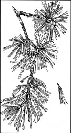 Detail of Whitebark pine. Drawing by Mike Cook, 1993. |
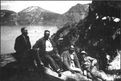
According to a symposium paper presented in 1989 by research ecologists Katherine Kendall and Stephen Arno, there is a close correlation between the size of whitebark pine cone crops and human encounters with grizzly bears (Ursus arctos) at Yellowstone National Park. In years of large cone crops, grizzlies spend the fall raiding squirrel middens in the subalpine forests. When smaller cone crops occur, the bears must wander in search of food and cause conflict with park visitors or staff. Since the mortality and reproductive rates of grizzly bears at Yellowstone are closely correlated with the size of whitebark pine crops, maintaining healthy stands of P. albicaulis is essential for maintaining the park’s population of grizzly bears. Although grizzlies have been absent for more than a century at Crater Lake, local populations of black bears(Ursus americanus) are sometimes forced to depend on whitebark pine nuts in order to survive the snowy winters. I confirmed this upon seeing the footprints of a black bear while collecting data from plots on Scott Bluffs. The bear scat found near the prints appeared to entirely consist of whitebark pine cones.
Katherine Kendall writes that because whitebark pine occurs at high elevation within the western United States, most of the responsibility for preserving this species falls on the managers of public land—namely the National Park Service and U.S. Forest Service. Fifteen units of the National Park System are known to include stands of whitebark pine, yet the small amount of information available concerning blister rust presence, mortality, and the extent of living whitebark pine is too often derived from casual observations or assumptions based on extrapolated evidence.
Since current research indicates that whitebark pines are declining due to blister rust and no published information was available about blister rust at Crater Lake, park managers wanted to conduct a systematic study to evaluate the health of our whitebark pines. The first set of plots sampled the pure and extensive stands of whitebark pines on Mount Scott, Cloudcap, Anderson Bluffs, and Scott Bluffs. After taking baseline data at each study plot, these points can be checked later to track the health of these trees. The study found a low rate of whitebark pine mortality (only 4 percent) and no blister rust. This is good news for Clark’s nutcrackers (Nucifraga columbiana) and other wildlife that depend on whitebark pine nuts. Other whitebark pine stands will be sampled in the future to develop a clearer picture of blister rust distribution in the park.
Like any good study, this one raises more questions than it answers. Why is blister rust present in other white pines of the Cascade Range but not on Mount Scott? Does the geographic position of Crater Lake National Park play a role in inhibiting the spread of blister rust? Are harsh conditions on Mount Scott preventing the fungus from successful reproduction? Could it be that measures to control Ribes during the late 1940s and in the 1950s are still having an effect? Further study will shed some light on some or perhaps all of these questions. Until then, we may continue to enjoy the beauty of whitebark pines around the rim of Crater Lake and in the vicinity of a peak the Klamath Indians called Tomsandi, known to newcomers as Mount Scott.
Reference
J.S. Boyce, Forest Pathology. New York: McGraw-Hill, 1961.
Susie Donahue currently resides in New Mexico but worked seasonally at Crater Lake beginning in 1993.
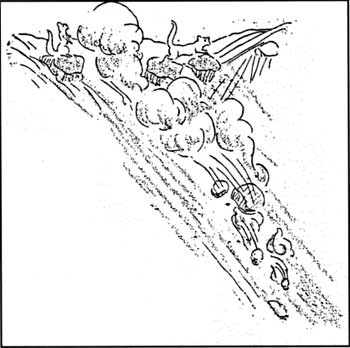
Drawing by D.L. Evans, 1932.
Other pages in this section