

Volume 32-33, 2001-2002
All material courtesy of the National Park Service. These publications can also be found at http://npshistory.com/
Nature Notes is produced by the National Park Service. © 2001
Introduction
Great names rise to the big occasion, or so goes the old adage. Several authors in this edition were intrigued by the idea of a double issue to mark the centennial of Congress acting to establish Crater Lake National Park. Others responded once they knew that the writer intends to retire as editor of Nature Notes from Crater Lake with the appearance of this publication for the tenth consecutive time since 1992. Whatever their reasons for contributing, authors have once again offered an engaging mix of topics for the largest issue ever published.
This edition will cap an experiment that began as part of a symposium held over three days in May 1992 to celebrate the 90th anniversary of Crater Lake’s designation as a national park. I wanted to find out how long a publication focused on natural history at the local level might last, given that all the contributions would have to be volunteered. The hiatus in printing Nature Notes from Crater Lake had lasted for more than three decades, with the end of a second string of publishing it on an annual basis coming at a time when ranger naturalists (later called seasonal interpreters) still had project time to complete their submissions.
The relative luxury of interpreters having project time to produce articles for Nature Notes had long since disappeared by 1992 due to a variety of factors, so I had to cast a wider net to reach potential contributors. Some of the interpreters responded, as did employees in more specialized resource management positions. Several park alumni became a mainstay for contributions and often produced exceptional submissions in giving certain issues a more robust quality than ones solely dependent upon what paid staff could produce on their own time. Authors who had never worked for the National Park Service gave a few volumes the necessary variety of topics and a fresh perspective. To everyone who helped I wish to extend a most sincere thank you!
This third series of Nature Notes from Crater Lake was not possible without an audience whose support allowed the Crater Lake Natural History Association to, in some measure, come close to breaking even on printing costs. With most volumes now out of print, I heartily recommend the park’s official website for those interested in reading back issues. Please visit www.nps.gov/crla, then go to “Park History” and click on “Nature Notes.” Randall Payne, Jamie Halperin, and June Jones deserve the credit for making this kind of access to the archives possible.
The Crater Lake Natural History Association sponsors this publication as part of an ongoing commitment to the educational and resource management programs of the National Park Service. Please join them in this effort by becoming a CLNHA member and in the process receive a 15 percent discount on all items sold by the association at Crater Lake National Park and Oregon Caves National Monument. A list of these items is available from the Business Manager, Crater Lake Natural History Association, P.O. Box 157, Crater Lake OR 97604; (541) 594-2211, ext. 498.
Oregon’s Two Largest, Deepest, Bluest, Purest Lakes: A Comparison
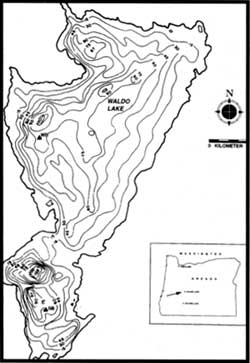 Bathymetric map of Waldo Lake with depth contours in meters. |
The Cascade Range holds lakes unmatched in the world. In comparing two of its more prominent lakes, Crater Lake in the southern part of Oregon and Waldo Lake in the central part of the state, there are some superficial similarities but also distinctive differences. The latter become readily apparent as each lake gradually becomes more familiar to visitors, though the significant attributes of each lake can be set apart from most other lakes anywhere in the world. As exceptional oligotrophic (nutrient-poor) bodies of water, Crater Lake and Waldo Lake are well worth the cost and effort to ensure their protection “for all people, for all time.”
Locations
Waldo Lake is situated about 190 km south-southeast of Portland, Oregon, at an elevation of 1650 meters above sea level. It is 9.6 km long and has a surface area of 25.5 square kilometers. Its bottom is gently sloping to a maximum depth of 128 meters on the lake’s western side. Water received into the lake falls on an area about twice as large as the lake itself. Soils are organically poor and well drained, with bedrock less than two meters below the pumice and rounded boulders. The forest surrounding the lake contains lodgepole pine, western white pine, mountain hemlock, western hemlock, Douglas fir, noble fir, true fir, and Engelmann spruce. Management of the area is the responsibility of the U.S. Forest Service staff on the Willamette National Forest. The western shores of the lake adjoin the Waldo Wilderness Area. The northern tributaries of the Willamette River’s middle fork flow from the northwest of Waldo Lake.
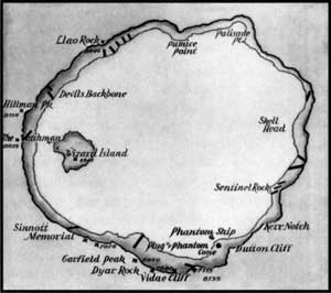 Crater Lake with key features around the rim. |
Crater Lake is located 130 km northeast of Medford, Oregon. Vertical cliffs surround the lake and are remnants of the collapsed Mount Mazama volcano. The lake basin is enclosed in a caldera and composed of varying amounts of andesite, pumice, rhyodacite and other igneous or volcanic materials. The adjoining forest includes mountain hemlock, Shasta red fir, lodgepole pine, western white pine, and whitebark pine. The National Park Service manages Crater Lake. Most of this national park area is de facto wilderness except for several road corridors and developed areas devoted to administrative functions and visitor facilities. No known surface streams flow out of Crater Lake.
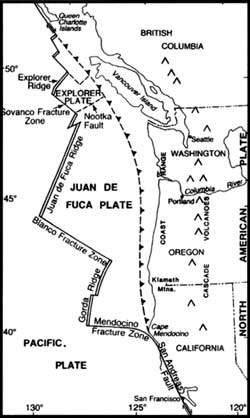 Plate tectonics relative to the Pacific Northwest. |
Geological settings
At the grandest scale, the High Cascades of Oregon are a product of plate tectonics. As plates of the Earth’s crust subduct off the Oregon coast, crustal material melts and these magmas are found again on the surface as volcanoes. Waldo Lake rests in an area of the High Cascades in a basin composed of basaltic andesite that flowed about 750,000 years ago. It was produced from a group of volcanoes named Waldo Mountain, Cupit Mary Mountain, Fuji Mountain, Mount Ray and The Twins. These lavas however, have been reworked by glacial ice. The area is covered with a fine powder left by ice as it grinds against rock. The glacier that excavated Waldo Lake moved in a northward direction, originating in the highlands between Mount Ray and Fuji Mountain.
Material pushed by a glacier is called a moraine and can sometimes provide barriers for a lake to form. Ice, like water, flows downhill. At the time the Waldo Lake basin was formed, a geologic fault existed just along the west edge of the present lake. The glacier mostly flowed north, but a tongue of ice headed west into the Black Creek drainage as the glacier gained height. It followed the north-south trending fault, marking the western edge of the High Cascade graben (a depression bounded by faults on at least two sides). The glacier did the actual work of excavating the lake, but the fault controlled where that work would take place. If the main glacier had headed into the Black Creek drainage, there would be no separation of the lake basin from the creek drainage and Waldo Lake would not exist. Waldo Lake filled the basin as the glacier melted, suggesting that this water body is 10,000 to 12,000 years old.
Crater Lake is located in the caldera of a collapsed volcano, Mount Mazama. The mountain is also a part of the High Cascades, but in southern Oregon. The overlapping shield and stratovolcanoes that today contain Crater Lake began to be formed about 420,000 years ago. About 7,700 years ago, in a cataclysmic eruption that may have lasted for days, the volcano spewed 50 km3 of ash and pumice into the air covering much of the Pacific Northwest. The magma chamber feeding the eruption was eventually depleted of most of its contents so it could not support itself and collapsed. This feature is termed a caldera. What is unique about this feature is that it contains the deepest caldera lake in the world.
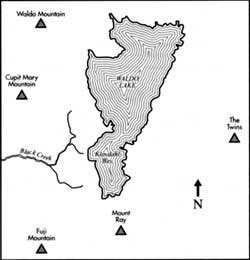 Geographical features in the vicinity of Waldo Lake. |
The collapsed volcano continued to erupt, sealing the floor of the caldera. Two cinder cones were formed on the caldera floor, with one (Merriam Cone) being formed below the lake’s surface and the other (Wizard Island) forming above the surface. The lake began to form within 500 years of the mountain’s collapse. Heat from Mount Mazama’s magma chamber still affects the water of Crater Lake. Not that the heat is enough to alter the surface temperature of the lake, but water circulates down toward this heat reservoir and returns containing chemicals from the geothermal sources located below. Rock on the lake floor is altered by this hot water, and this circulating water chemically alters the lake. This makes Crater Lake fundamentally different from other lakes in the High Cascades.
Physical aspects of the two lakes
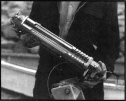 Equipment for measuring light in Crater Lake, 1940. NPS photo. |
Both Waldo Lake and Crater Lake have very small watersheds. Crater Lake occupies a little more than 78 percent of its watershed, meaning that most of the rain and snow input falls directly into the lake from the sky. Waldo Lake occupies about 32 percent of its watershed, suggesting that almost two thirds of the precipitation falling in the Waldo watershed arrives indirectly, by way of land. Waldo Lake would take 30 years to fill with water, given present rainfall and the evaporation rates. That period of filling for Crater Lake would be somewhere between 200 and 300 years. Water falling as rain or snow allows these lakes to exist, but water quality is also affected by the particular characteristics of the respective lake basins.
Water levels of both lakes have remained relatively constant due to three processes: inflow, outflow, and evaporation. The inflow at Crater Lake is almost totally precipitation. In 1985, when the author helped to survey the caldera walls for springs, he was astounded to find 51 surface water inflows into Crater Lake. Few of these springs flow throughout the year, though some include wonderful waterfalls that sometimes drop directly into the lake. Trying to collect water from this type of spring has led to my being ‘soaked to the bone.’ Waldo Lake has no creeks flowing directly into it throughout the year. Ground water, however, flows into the lake thereby offsetting the lake’s outflow.
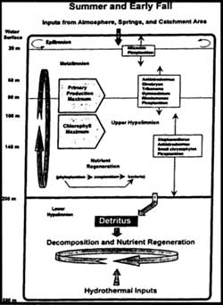 Simple model of the vertical distribution of selected physical, chemical, and biological components of the limnetic zone of Crater Lake. Curved arrows in the epilimnion indicate a zone of circulation and mixing. Graphic courtesy of Gary Larson. |
Swimming in Waldo or Crater Lake is a thrilling experience, largely because of their temperatures. The warmest surface temperature recorded in Crater Lake is 19.2°C, but the maximum some years does not get above 15°C. The same surface temperatures may be measured at Waldo Lake. A lake’s upper stratum near the surface (called the epilimnion) is the warmest layer because lakes absorb heat from the more direct sunlight during summer. Just below this warm layer is a layer of water that changes from the warm surface to the cooler deep water. This transition zone is called the metalimnion, or thermocline. Both lakes share similarities in this zone, one beginning at about 20 meters in depth and extending to roughly 50 meters. There is low heat absorption below 50 meters, so temperatures remain between 4 and 6°C at Waldo. This deep-water zone is termed the hypolimnion and at Crater Lake the temperature remains between 3.5 and 3.7°C. It is in this zone where the two lakes display a marked difference. Some geothermal heat enters Crater Lake from the caldera in which the lake rests, so the water of Crater Lake increases slightly in temperature below 300 meters.
As winter approaches, lakes begin to cool. The cooling of surface water causes this layer to increase in density and sink. The sinking and mixing with deeper water allows chemicals deep in the lake to become available to plants and animals in the shallower parts of the lake, thus a fall ‘bloom’ may occur. As the lakes cool further, ice may form. It is just as unusual for Waldo Lake to not freeze in a winter season as it is for Crater Lake to freeze. The single difference here is depth. Crater Lake is over eight times deeper (using its average depth) than Waldo Lake. This great reservoir of water (and heat) can keep the surface of the lake from freezing. As the surface of a lake cools, it becomes denser—though sinking cool water is offset by rising warmer water. At Crater Lake this can go on all winter. The rising ‘warm’ water at Waldo Lake does not carry the same amount of heat, so the lake will cool below the freezing point of water.
Table I. Comparative Features of Crater Lake and Waldo Lake
| CRATER LAKE | WALDO LAKE | ||||||
| Elevation | 1882m | 6170ft | 1650 | 5410 ft | |||
| Maximum Depth | 589m | 1930ft | 128 m | 420 ft | |||
| Mean Depth | 325m | 1070ft | 39 m | 128 ft | |||
| Surface Area | 53.2 km2 | 20.5 mi2 | 25.5 km2 | 9.85 mi2 | |||
| Volume | 17.3 km3 | 4.15 mi2 | 0.949 km2 | 0.23 mi3 | |||
| Annual Precipitation | 1.71 m | 67.3 in | 1.8 m | 70.9 in | |||
| Water Retention Time (yrs) | 150 | 150 | 30 | 30 | |||
| Length | 9.7 km | 6.0 mi | 9.6 km | 6.0 mi | |||
| Width | 8.2 km | 5.1 mi | 4.3 km | 2.7 mi | |||
| Watershed Area | 14.6 km2 | 5.6 mi2 | 53.5 km2 | 20.7 mi2 | |||
| Watershed (%) | 78.5 | 32.3 | |||||
| Surface Outflow | None | North Fork, Middle Fork, Willamette River | |||||
| Nitrate ion (mg/L) | 1 – 17 (low on surface) | 0.2 | |||||
| Ammonia (mg/L) | 2-4 | 2.4 | |||||
| Total Phosphorus (mg/L) | 22 – 28 | 2.9 | |||||
| Dissolved Phosphorus (mg/L) | 11-15 | 0.9 | |||||
| Conductivity (mS/cm) | 116 | 3.5 | |||||
| Alkalinity (mg/L) | 25 – 31 | 0.58 | |||||
| Sulfate ion (mg/L) | 10 | 0.11 | |||||
The two lakes appear blue because of the interaction of sunlight with the water. A lake will appear colored due to materials suspended in the water (mud, algae), the reflection of sky or clouds, and because of certain colors in the spectrum of sunlight being absorbed by the water. These two lakes have very little suspended material in the water, and so appear clear. Water around the shore appears clear with rocks and sand easily visible. As the water gets deeper, the bottom appears green or blue green the lake absorbs the red, orange, yellow colors of sunlight more readily than the green and blue colors. If the water is more than 60 meters deep, the water appears blue.
Research staff at Crater Lake purchased an underwater spectral irradiometer in 1995. This device measures the light spectrum reaching down to 200 meters in the lake. Red light is quickly absorbed, but the lake transmits blue light of precisely 478 nanometers in wavelength in the deep water. This is the color of Crater Lake that one sees. The irradiometer has not been used in Waldo Lake, but is expected to return similar data. Light in a lake or an ocean eventually becomes so low with increasing depth that one would admit that it was dark. When one investigator took a submarine to a depth of 450 meters on Crater Lake floor, however, he turned all the electric lights off and was able to “see” a slight amount of sunlight from the surface. This is the mark of a lake with incredibly clear water.
 Artist ‘s rendition of a Secchi disk on its descent into the water. Graphic courtesy the author. |
The simplest test of clarity of a lake is to use a “pie plate on a string” or, officially, the Secchi disk. This 20-cm diameter metal or weighted plastic disk is usually quartered black and white. It is lowered into a lake and the depth at which it disappears is recorded. The Secchi clarity depth at Crater Lake was recorded in June of 1997 at 43.3 meters. At Waldo Lake the deepest Secchi depth was measured to be 41.3 meters in July 2001. This “eyeball” test of a lake’s water clarity greatly depends upon the sky conditions and the lake surface. If clouds obscure the sun or the lake is ruffled by wind, the disk will prematurely disappear. To put this test in perspective, many lakes with large watersheds seldom have Secchi depths of greater than 10 meters. Muddy water may have a Secchi depth of less than one meter. In this case, two world-class lakes are being compared and can be seen to be very similar in clarity. It should be noted, however, that Waldo Lake does not currently host a full-time research effort while Crater Lake does. It is very difficult to record the best Secchi clarity depths on a part-time basis. Visiting the lake for a day or two each month lessens the chances that the sky and lake surface conditions will be ‘perfect’ for viewing the disk.