
Management concerns
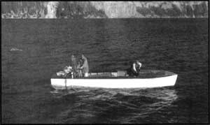 Research on Crater Lake in August, 1960. NPS photo by Jack Boucher. |
Crater Lake attracts an average of 500,000 people each year. Roughly 10 percent of these visitors walk down a relatively steep trail that serves as the sole access point to the lake in order to swim, go fishing or take the tour boat around the lake. Impacts to the lake from visitors are relatively minimal as far as is known, but long term trends or effects are still imperfectly understood. Waldo Lake attracts fewer visitors, but the lake is ‘at their campsite.’ Visitors can park a few feet from the lake, swim, launch a boat or camp. The 14 mile gravel road to Waldo Lake was paved in 1964 and visitor use increased dramatically. By 1982 visitor-use days reached 50,000 and that figure climbed to 103,000 visitor-use days by 1998. Waldo Lake appears to be more sensitive and at risk of being more impacted than Crater Lake, though restroom facilities near the shore are being replaced by composting toilets and more rustic campgrounds are being eliminated around the lake.
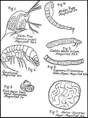 Biota of Crater Lake. From Nature Notes, Vol. VIII, No. 2, Aug. 1935. |
Crater Lake has enjoyed a National Park Service sponsored research program since 1982. Between 1978 and 1981 some limited support helped to start a lake monitoring and research program. Crater Lake now has several full-time biologists and ecologists actively collecting data and working on research questions with an infrastructure of offices and laboratory facilities. A boat house on Wizard Island allows for research activities in winter as well as temporary living quarters and laboratory space. The two research boats on Crater Lake are similar to the research vessels used on Lake Tahoe and are versatile enough be employed in a wide range of studies.
Waldo Lake is not so well supported, though the Forest Service has stretched its limited watershed monitoring funds. The Oregon Department of Environmental Quality has also funded some limited research on the lake. There is no full-time limnologist or ecologist assigned to the monitoring efforts at Waldo Lake, though the writer has enjoyed some support for his involvement at Waldo Lake since 1986. The Forest Service has no boat, laboratory, nor equipment to monitor Waldo Lake and so must contract with others to do this work.
It should be said a research program involves measuring a wide array of chemical and biotic indicators for these two pristine lakes. Interested readers should examine the accompanying table for some of the indicators used as a basis for comparing Crater Lake with Waldo Lake. The references below are included for those wanting more specific information about past and present studies.
References
Ellen T. Drake, et al. (eds.), Crater Lake: An Ecosystem Study. San Francisco: Pacific Division of the American Association for the Advancement of Science, 1990.
Daniel M. Johnson, et al., Atlas of Oregon Lakes. Corvallis, Ore.: Oregon State University Press, 1985.
James F. LaBounty and Douglas W. Larson (eds.), Lake and Reservoir Management(journal issue devoted to Waldo Lake) 16:1-2 (2000), pp. 1-150.
James E. LaBounty and Gary L. Larson (eds.), Lake and Reservoir Management (journal issue devoted to Crater Lake) 12:2 (1996), pp. 221-310.
John Salinas studied lakes throughout Oregon after being inspired by Crater Lake as a seasonal naturalist. He teaches science at Rogue Community College in Grants Pass, Oregon.
Fish in Crater Lake: Their Size and Number
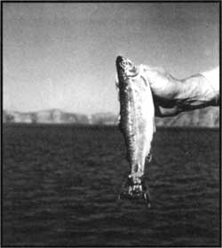
 Ranger-naturalist Arthur Hasler showing a rainbow trout to visitors in 1938. NPS photo. |
Anglers who routinely ‘wet a line’ in Crater Lake have learned that fishing success as well as the size of kokanee salmon and rainbow trout in the lake can fluctuate dramatically from year to year. Analysis of fish length and fish population size over the last 15 years provides insight into the patterns of change and may help anglers appreciate the ups and downs of fishing Crater Lake.
Crater Lake was naturally barren of fish until park founder William Steel first stocked Crater Lake with trout fingerlings in 1888 to “improve” recreational opportunities. Despite altering the lake’s natural condition, introductions of non-native fish continued until 1941, when stocking the lake ended. In all, five species of salmonids, totaling nearly two million fish, were introduced to the lake over the intervening 53 years. Brown trout (Salmo trutta), cutthroat trout (O. clarki),coho salmon (O. kisutch), kokanee salmon (O. nerka, a landlocked sockeye salmon), and several stocks of rainbow trout (O. mykiss) including steelhead were introduced during this period. Only the self-sustaining populations of rainbow trout and kokanee salmon persist in the lake today.
 Kokanee salmon. NPS photo by C. Warren Fairbanks, 1954. |
Detailed annual fish population estimates using high-tech acoustic systems were initiated in Crater Lake in 1996. The largest fish population observed in Crater Lake since that time occurred during the summer of 2000 when biologists estimated the total number of fish in Crater Lake at 633,000—a density of 48 fish per acre. Lake Billy Chinook near Bend, by contrast, is estimated to contain between 530 and 5500 kokanee per acre depending on the year. Coeur d’ Alene Lake in Idaho typically fluctuates around 1400 fish per acre. The lowest number of fish in Crater Lake occurred in 1998 when only 8,400 (less than 1 fish per acre) were observed. Just two years later the fish population in Crater Lake increased by an astounding 7450 percent!
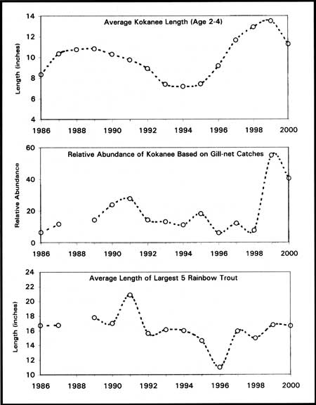
The relative abundance of kokanee has been monitored with gill nets since 1986. Population size and the average length of individual kokanee salmon cycles over a period of approximately ten years (see the first two graphs in Figure 1). According to fisheries studies around the Pacific Northwest, fluctuations in kokanee population size and fish length are fairly common in unproductive bodies of fresh water such as Crater Lake. Large increases in kokanee population size that occurred in the lake during 1990-91 and 1999-2000 could therefore be expected.
Biologists studying Crater Lake believe that at low population size, food is plentiful for the kokanee and a fewer number of fish eventually reach larger size. These large and healthy adult fish reproduce successfully leading to an increase in fish numbers. As the fish population increases, the primary food of kokanee (microscopic animals in the water column called zooplankton) decreases to the point that the lake can no longer support such a high population of fish. The kokanee population size then falls through time, allowing the zooplankton population to recover so that the cycle starts over again. In water bodies other than Crater Lake, the patterns in kokanee size and number are subject to more variables such as fluctuations in water level (this is especially pronounced in reservoirs), water temperature, fish stocking density, the timing of stocking, and harvest pressure from anglers.
Rainbow trout do not feed on zooplankton like kokanee do, but instead rely mostly on aquatic insects near the lakeshore as well as those that land on the lake surface. Large rainbow trout will also eat small kokanee. The length of the largest rainbow trout caught in Crater Lake over the last 15 years has varied similarly to that of kokanee, but delayed by 1-2 years (compare the upper and lower graphs in Figure 1). Large rainbow trout were prevalent in 1991 (see Table 1) and have been increasing in number the last few years. Not surprisingly, the presence of exceptionally large rainbow trout appears to be associated with the presence of large numbers of small kokanee.
Research has shown the ecology of Crater Lake to be very dynamic and the fish population is no exception. Recent studies suggest that the quality of fishing in the lake for the foreseeable future will fluctuate depending upon the year. The extremely large increase in kokanee numbers during 1999 and 2000 will probably result in their population crashing (probably due to over exploitation of their food resources) in the next few years. This was already becoming apparent in the summer of 2000, given the dramatic increase in kokanee numbers over the previous two years.
With numerous small kokanee salmon present, the summer of 2001 could turn out to be a great time to catch that big rainbow trout in Crater Lake. Although the density of fish in Crater Lake will probably never be high like other more productive lakes of the Pacific Northwest, some days at Crater Lake still promise to be very good fishing. Other days may not be so good, but if you are going to experience a bad day of fishing I cannot think of a better place to go than beautiful Crater Lake.
Note: Fishing access at Crater Lake is fairly limited because of the steep and dangerous caldera walls encircling the lake. A quarter mile section of shoreline is accessible at the base of the Cleetwood Cove Trail for fishing. Anglers can reach Wizard Island in the tour boat operated by the park concessioner, a service allowing passengers to disembark and fish on a day use basis. Devices such as float tubes and rafts are not allowed on the lake due to erratic winds, jagged rocks, and steep shorelines.
Crater Lake National Park’s Long-term Limnological Monitoring Program assesses many chemical and physical aspects of Crater Lake’s ecology. Part of monitoring the fish population involves setting nets to collect fish for analysis. Each fish collected in the nets is measured for length, weight, sex, and maturity level. Scales are collected from each fish to determine fish age. The stomach contents of the fish are preserved for later analysis. The monitoring program also uses a scientific-grade acoustic system (a fancy “fish finder”) to accurately estimate the population size in the lake and assess fish distribution within the water column.
Table 1: Length (inches) of largest fish caught in nets by biologists between 1986 and 2000.
| Kokanee | Rainbow | |||
| Largest fish caught | Average length of largest 5 fish caught |
Largest fish caught | Average length of largest 5 fish caught |
|
| 1986 1987 1988 1989 1990 1991 1992 1993 1994 1995 1996 1997 1998 1999 2000 |
10.5 13.515.6 16.1 11.2 10.8 11.0 9.4 8.8 10.3 16.3 14.7 14.2 15.2 |
9.4 12.314.5 12.3 10.9 10.5 9.5 8.5 8.5 10.2 13.9 14.1 13.4 13.9 |
17.8 18.918.9 17.8 23.1 17.3 21.4 16.7 16.8 13.5 19.1 17.5 18.7 19.9 |
16.7 16.817.8 17.0 20.9 15.7 16.2 16.0 14.6 11.0 16.0 15.0 16.8 16.7 |
Scott Girdner is a fisheries biologist with the National Park Service who has studied Crater Lake since 1995.
Witness to a Catastrophe
The eruptive collapse of Mount Mazama represents the biggest volcanic event to occur in North America over the last 10,000 years. Massive deposits of scoria and pumice blasted the volcano’s slopes and still continue to fill the stream drainages in the surrounding region. Remains of an ancient forest can still be seen beneath this material in many of the road cuts around the park. It is evidence of destruction involving 12 cubic miles of ash and pumice. A caldera resulted from this destruction about 7,700 years ago, replacing an edifice that may have reached 12,000 feet high. Few places were left unaffected by this catastrophe, but one peak fared better than most.
 The view from Mount Scott. NPS photo. |
Following Mazama’s climactic eruption, the summit of Mount Scott became the highest point in the immediate vicinity with an elevation of 8,929 feet above sea level. Mount Scott was named in honor of Levi Scott, a man who explored southern Oregon in the middle of the 19th century. Its name in the Klamath language is Tum-sum-ne orTomsandi. The geological origin of this peak has been re-examined in recent years, with improved dating techniques allowing Dr. Charles Bacon of the U.S. Geological Survey to better fit this peak into the broader story of Mount Mazama.
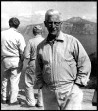
Dr. Howel Williams, who wrote The Geology of Crater Lake National Park some 60 years ago, believed that Mount Scott developed late in the history of the great volcano. He described Mount Scott as a “parasitic” cone that owed its existence to the larger Mazama. Modern radio-metric dating methods have allowed Dr. Bacon to amend Williams’ assessment. Not only is Mount Scott now believed to be a part of a complex of cones that combined to form Mount Mazama, it is possibly the oldest member of this complex.
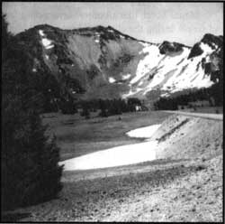
The silica-rich lavas of Mount Scott have been dated to 420,000 years, roughly 20,000 years older than any other rocks found immediately around or within the rim of Crater Lake. The great age of these flows has helped to explain why the cone is so eroded in its appearance. Seen from the east, Mount Scott has a conical shape. When seen from other directions, however, a broad amphitheater quickly becomes apparent. With its central core missing, it is easy to wonder about the cause of such great alteration in what was originally a great cone.
Mount Scott, like all other surrounding features, was blasted by avalanches of hot pumice and scoria during the climactic eruption of Mount Mazama. The real dint to its shape, however, took place centuries prior to the big blast. During at least three, and possibly four extended periods, glaciers advanced over this and other peaks in the Cascade Range. Ice slid down and created the west slope that geologists call a cirque. The abrasive effect of these mile-thick rivers of ice should not be trivialized. The broad slopes surrounding Mount Thielson, located north of Mount Scott are missing altogether because of what the glaciers carved. The same can be said for Union Peak, a promontory situated some 10 miles to the southwest of Mount Scott.
 Whitebark pines. NPS photo by Jack Boucher, 1960. |
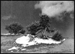
The pumice and scoria now covering flanks of Mount Scott eventually became a suitable habitat for subalpine trees. Whitebark pines(Pinus albicaulis) are especially adapted to the higher elevations . Their flexible limbs bend easily under the weight of the heavy winter snow pack. Clusters of needles, five in a bunch, are assembled at the ends of branches and give each the appearance of a bottlebrush. As you ascend the Mount Scott Trail, take notice of how these trees become visibly shorter with elevation. A reduced growing season has both depressed the numbers of these trees and their size. The prevailing wind has also shaped their appearance, especially within the cirque. Trunks and limbs all bend back and away from the strong winds that come across Crater Lake from the west.
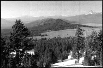
A splendid view from the top rewards everyone who climbs to the top of Mount Scott. Looking east, across the Klamath Marsh, observers often see expanding cumulus clouds on warmer summer days. The Three Sisters, located a hundred miles north, display icy tops just barely visible to the left of Mount Thielson on clear days. The best view by far, and one that draws considerable attention, is the view of Crater Lake. Nowhere else in the park do observers see the entire display of island, rim, and water as well as from Mount Scott. Perhaps the combination of being up high enough, and a bit removed from the rim of Crater Lake, allows for a new perspective on the decapitated mountain.
As previously indicated, Mount Mazama was not a single cone. Just as the Three Sisters and Broken Top are considered a volcanic complex, so too was the Mazama volcano. The difference here, however, was that most of the units that combined to form Mount Mazama were so close together that their lava overlapped. The exception, of course, was Mount Scott. All members of the Mazama complex derived their fluids from the same magma source beneath the surface. Mount Scott formed first and others followed to the west of it.
 Mount Scott from Rim Drive, where the glacial cirque is plainly evident. NPS phto by Bruce Black, 1959. |
Fortunately for those who appreciate Mount Scott in the present, it was located too far east to collapse into the same magma chamber as Mazama had 7,700 years ago. During the climactic eruption, however, an observer on Mount Scott would have been in great danger. Avalanches of hot pumice and scoria raced down the slopes of Mount Mazama and boiled over the top of Mount Scott. Fallout from a four-mile high plume of pumice also landed on the top of this cone.
It is difficult, when standing on top of Mount Scott, to comprehend the catastrophe that occurred here almost eight millennia ago. The peaceful setting of this place adds to a deceptive illusion of permanence. It is worth remembering that geologists have determined that the source of Mazama’s climactic eruption is still intact, and fully capable of building new volcanic edifices here in the future.
Tom McDonough first came to work at Crater Lake as a seasonal naturalist in 1969 and has taught science at Chemeketa Community College in Salem, Oregon, since 1975.
Cinder Cones in Crater Lake National Park
By K. R. Cranson
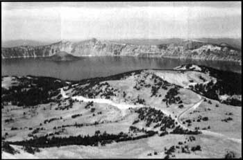
Visitors to this national park marvel at the spectacle of a large volcano that collapsed nearly eight thousand years ago to produce a basin now filled with indescribably blue water. Indeed, the geological story of what happened to produce the Crater Lake basin that we see today may be the best description of a “young” caldera in the world. There are, however, numerous other interesting volcanic features in the park. At least 20 cinder cones have been identified within the boundaries of Crater Lake National Park. And, of course, Wizard Island, the most famous of these, rises more than 700 feet above the lake’s surface near the western shoreline and is well known to all visitors.
Cinder cones as landforms
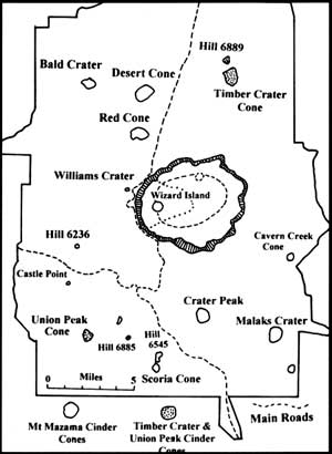 One simple method of classifying volcanoes groups them into three categories: shield volcanoes, strato-volcanoes, and cinder cones. Shield volcanoes are massive, low, dome-shaped features produced primarily by fluid lava flows, and usually composed of basalt. The islands of Hawaii are examples of these huge volcanic features but only a small portion is visible above sea level. A strato-volcano is constructed layer by layer of more or less alternating lava flows and pyroclastics (loose fragments erupted during explosive activity) that tend to be large features on land with relatively steep slopes. They are the subjects of picture postcards and calendars. In the Cascade Range, Mount Rainier and Mount Shasta are good examples of strato-volcanoes.Figure 1: Location of the major cinder cones in Crater Lake National Park, Oregon. The dashed line inside the caldera represents the location of Merriam Cone and the ring fracture zone where post caldera eruptions reached the surface. The Central Platform is outlined by the dotted line. Sketch by the author.
Cinder cones are the “baby” members of the volcano family listed above. They seldom exceed a mile across at the base and a thousand feet high. Unlike the shield or strato-volcanoes, this smallest member of the volcano family have an extremely short life span—being active for just days to a few months in most cases. Only in rare occasions does their activity extend for a year or more. From a geological perspective, this is like an instant or a snapshot in the volcanic record of an area. Due to their origins, cinder cones are called “monogenetic,” with the entire feature built during one eruption episode from one source of magma.
A typical cinder cone eruption begins by venting magma rich in gas that expands, producing solid fragmental volcanic products like blocks, bombs, scoria, ash and dust. This ejected material, the pyroclastics noted above, accumulates at a single location to build an inverted cone around the vent. The larger and heavier particles collect closest to the vent, while smaller and lighter ones drift farther—or are carried away by the wind. As the cone grows, a central region may develop composed of the larger pieces (blocks, bombs and scoria) mixed with more fluid magma that hardens into a rigid core. On a young cone this core is seldom seen as it is usually buried by additional pyroclastic material blown out of the vent later.
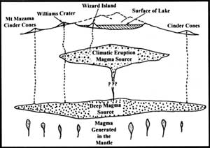 Figure 2: Schematic cross section of magma sources for cinder cones and the climatic eruptions at Crater Lake National Park. The outer margins of the Climatic Eruptive Magma Source defines the shadow zone, that portion of Mount Mazama that collapsed to form the caldera. Sketch by the author. |
In time, the gas dissolved in the magma that powered the explosive initial eruption is exhausted and magma reaches the surface as lava. When this happens, lava flows may break out from the base of the cinder cone and flow away from the volcano. Magma forming cinder cones is typically basaltic or basaltic-andesite in composition. Lavas with this composition tend to be relatively hot and flow readily, sometimes for great distances. Although the most prominent part of these small volcanic features is the cone that develops, associated lava flows may actually contain up to ten times more volcanic material. Since cinder cones are relatively small features, they are often overlooked. They are, however, the most abundant kind of volcanic cone—being common worldwide and numbering in the thousands. One report suggests that at least 400 cinder cones have formed in the Oregon portion of the Cascade Range alone. Most of those in Crater Lake National Park are associated with the construction of Mount Mazama. Wizard Island, of course, was formed in the caldera following the collapse of Mazama’s summit.
Cinder cones generally develop in volcanic areas that do not have larger volcanoes, or are associated with more massive volcanic cones. Those related to larger volcanic features, like shield and strato-volcanoes, usually develop along weak areas in existing rock. Such zones are often referred to as basement fractures and tend to be radial to the larger volcano—something like the spokes of a wheel. Although this is not obvious for the cinder cones at Crater Lake, connecting certain pairs does produce a crude radial pattern. Examples are Desert Cone and Red Cone, or Scoria Cone and the adjacent Hill 6545.
Cinder cones in the park
 The southern flank of Williams Crater along Rim Drive on the west rim of the caldera. Basaltic magma rising to the surface vent here appears to have “tapped” some magma from the Climatic Eruptive Magma Source to produce “mixed magma” rocks. Photo by the author. |
The cinder cones in Crater Lake National Park fit into two categories: those associated with the small basaltic shield cones of Union Peak and Timber Crater, and all the others that are related to Mount Mazama. Hill 6902 and the cinder cone on its summit appear to be part of the Timber Crater shield volcano in the northern portion of the park. In a like manner, the southwestern quadrant holds Castle Point and its summit cones, along with several smaller cinder cones belonging to the Union Peak shield volcano.
Red Cone and Desert Cone, clustered in the Pumice Desert in the northwestern section of the park, are good examples of cones related to Mount Mazama. Both appear symmetrical when viewed from the North Entrance road, a distance of about a mile. As with most other cinder cones throughout the park, both have a symmetrical appearance when viewed from above. Other prominent Mount Mazama cinder cones include Bald Crater, Crater Peak, Scoria Cone and Maklaks Crater—the latter is called Diller Cone on older maps.
 Howell Williams at Crater Lake in 1965. NPS photo by Ed Paine. |
The cinder cones associated with Mount Mazama exhibit a large range in volume. Of the eight more prominent cones for which a volume has been determined, Crater Peak is the largest with a volume of just under a tenth of a cubic kilometer. Hill 6545, near Scoria Cone, is the smallest measuring somewhat less than a tenth the size of Crater Peak. Wizard Island’s volume falls about midway between these extremes.
Unlike the typical cinder cones described above, cinder cones located away from the caldera exhibit few lava flows. Since all of these cones predate Mazama’s climactic eruption, it could be that the flows are buried by eruptive material. The tendency to erode easily is another factor since the edifice of cinder cones is composed of loose debris. Older cinder cones are thus more rounded with lower slopes that result from erosional effects. In a like manner, summit craters are typical in younger cinder cones, like the crater nearly 100 feet deep on Wizard Island. For the other Crater Lake cones, however, only shallow depressions remain of any craters that may once have been present.
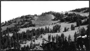
 Red Cone illustrating pyroclastic debris and forested northern slope. This cinder cone is typical of the small monogenetic volcanoes related to Mount Mazama outside the caldera. Photo by the author. |
All of the Crater Lake cinder cones are similar in composition. One method of describing and comparing the composition of volcanic rocks is expressed by how much silicon (Si) and oxygen their rocks contain. Reports of chemical analysis combine these two elements and express them as the percentage of SiO2. The great majority of cinder cones found in the park have a SiO2 range of between 52% and 58%, thus producing igneous rocks called basalt or basaltic andesite.
Based on the amount of weathering, soil cover, erosion and a few radiometric dates (the measurement of geological time by means of the rate of disintegration of certain radioactive elements), most cinder cones in Crater Lake National Park appear to be less than 50,000 years old. Radio-metric dates (using the potassium-argon method of dating, or K-Ar) have been made on rocks from four cones: Timber Crater, Red Cone, Scoria Cone and Desert Cone. Only the results for Desert Cone indicate an earlier formation with a date of about 200,000 years. It should be noted, however, that the ages resulting from such techniques have a very large range. For example, the age for Red Cone rocks is recorded as 36,000 years before present, plus or minus 12,000 years.
Williams Crater & Wizard Island
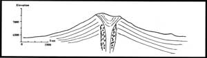 Figure 3: This east-west profile of Red Cone illustrates the typical shape of cinder cones at Crater Lake. Slopes for cones outside the caldera suggest some decrease from the original shape due to erosion. Angles for young, fresh cinder cones tend to be about 30°, similar to that of Wizard Island which has a slope of 29°. Sketch by the author. |
Just outside the west caldera rim a small cinder cone can be found called Williams Crater, previously labeled as “Forgotten Crater” on older maps. This feature may provide an interesting insight into the nature of the magma sources that produced Mount Mazama and the climatic eruptions. Some erupted materials appear to be formed from “mixed magmas” and contain both low and high SiO2 compositions. These have been interpreted as a mixing of the two different magma sources associated with the Mount Mazama region – the deep magmas and the climatic eruption magma source. Based on glacial erosion and other evidence, Williams Crater appears to have been active between 22,000 and 30,000 years ago.
All the volcanic features on the floor of the Crater Lake caldera developed after the collapse of Mount Mazama. Soon after the climatic eruption and collapse that created the caldera, renewed volcanic activity formed the central platform, Merriam Cone, Wizard Island, and other features. An estimated 3 km3 of post caldera volcanic material was erupted through a ring fracture system – most of it part of the Wizard Island edifice. Merriam Cone, rising some four hundred meters above the caldera floor, has the general appearance of a small cinder cone. Recent evidence, however, suggests it was formed below water. Wizard Island’s cinder cone rests on top of a pile of lava flows that extend eastward over the central platform.
Several research devices and techniques were used to map the topography of the caldera floor and investigate the nature of the rocks and sediments that occur in the Crater Lake basin. Rock samples collected from some 250 feet below lake level, on the flanks of Wizard Island, appear to have been in placed under water. The composition of these samples is identical to the youngest sub-aerial flows of the island’s cinder cone located above them. All this suggests that Wizard Island was built on top of lavas erupted to create the central platform in the rising waters of Crater Lake.
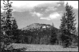 Timber Crater across Pumice Desert as viewed from the North Entrance road. This cone, resting on the summit of a small shield cone, is the largest cinder cone in Crater Lake National Park. Photo by the author. |
The maximum age of Wizard Island and Merriam Cone is constrained by the date of Mount Mazama’s collapse a little less than eight thousand years ago. There are various estimates of how long it took for the lake to fill to its current level. Other evidence suggests that Wizard Island formed very early in the history of the basin. Using radiocarbon (C-14) dates for the collapse, and allowing a few hundred years for the lake to fill, places Wizard Island’s age at about 7,000 years before the present. Its conical shape gives Wizard Island the look of a young feature, having suffered little erosion. Since there are no “hot” areas outside the caldera to suggest remnant volcanism, the lava flows at the western base of Wizard Island may represent the most recent volcanic activity in the park.
Over the past 20 years, a large, number of publications have resulted from intensive geological fieldwork. These efforts have concentrated on the construction, climatic eruptions, and ultimate collapse of Mount Mazama, resulting in the Crater Lake caldera. This is, of course, the geological story to be presented at Crater Lake National Park—the very reason the park was established. Other geologic features, such as the cinder cones, however, are also worthy of further investigation.
K.R. “Rod” Cranson is a geologist who worked at the park twice, 1967-68 and 1978-82. He is currrently in the midst of preparing a third edition of his book, Crater Lake: Gem of the Cascades.
Other pages in this section