

Volume 4 No. 2 – August 1, 1931
All material courtesy of the National Park Service. These publications can also be found at http://npshistory.com/
Nature Notes is produced by the National Park Service. © 1931
Another Page from the Past Discovered
By D. S. Libbey
“Nature! We are surrounded and embraced by her; powerless to separate ourselves from her, powerless to penetrate beyond her.”
“She is ever shaping new forms, what is, has ever been; what has been, comes not again. Everything is new, and yet naught but the old.”
—– Goethe —–
In last month’s Nature Notes mention was made of the numerous discoveries of carbonized wood or natural charcoal which have been made in the vicinity of the Rogue River where the Diamond Lake Road leaves the main highway. The writer has been back to the place of the fossil finds several times in an effort to secure a complete cross-section and after many futile efforts finally succeeded in securing a cross-section 28 inches in diameter, on Thursday, July 23.
Mr. Harshbarger, of the Clarence Young Construction Company, which is doing the excavating through the volcanic tuff and pumice on the Diamond Lake Road, called us to come down the side of the mountain some twenty miles and investigate the nature of the huge carbonized log which was found approximately 1850 feet above the place where the new road joins the Medford Highway. The log was covered by 55 feet of volcanic ash and pumice which has become thoroughly consolidated and the specimen was in a prostate position but with several lateral branches attached. The under side of the log still carried the thick layers of bark resting against very fresh appearing volcanic ash of a light gray color. The portion of the bark which was on the under side was in a remarkable state of preservation, uncarbonized, and the bark marking were very evident. The bark shows the characteristics of the Sugar Pine bark (Pinus lambertiana, Dougl.) and the carbonized log has numerous portions showing the vesicular structure (bubbles and globules) caused by the baking of the pitch in the log. Apparently the log was one which had just fallen prior to its entombment and the fact that carbonized branches were discovered seems to substantiate this opinion.
This find, in-situ, is considered a great value and the cross-section has been placed in the Sinnott Memorial Building where it will finally be assigned a very conspicuous place. The fossil section is now held intact by a girdle of pine boards securely bound by wire so as to make a retaining support. Very probably the section will subsequently be either bound together by a series of brass straps or incased in a matrix of plaster of paris because the terrific heat to which the log was subjected caused rather large crevices to form and the entire mass is very friable. This index from the past has the honor of being the first display exhibit to be placed in the now Memorial Building which was just dedicated on Thursday, July 16.
A week previous we had the pleasure of discovering another fossil log approximately 8509 feet down from the Medford Highway junction on the same construction project. One end of the log had been turned to charcoal, the other being of uncarbonized wood. The end of the preserved wood was covered by small pumice gravels and ash fragments which apparently had tumbled down an ash and pumice slope and the very definite bedding showed that the gravels were resting at the definite angle of repose for such material and it is apparent that the covering ash and pumice for the uncarbonized had come to rest and had tumbled down the slope while cold. Also the log possessed no limbs and indicated that it had floated to its place and then been buried under the cold pyroclastic material. Very probably the entire log may have been covered and then subsequent stream erosion had uncovered the lower end of it, that is the end nearer to the present course of the Rogue. Very definite stream laid depositions of gravel and sand were discovered both above and below the site of the specimen. A part of the uncarbonized wood has been obtained and will be placed in the Sinnott Memorial building along with the large cross-section of the carbonized log. The sequence of events seems to be that after the work of water had sorted the pumice load, a huge deposit of volcanic ash and pumice was spread over the material while the volcanic ejecta was still hot and hence the carbonizing of the down stream, and, incidentally, the westerly end of the log. It is unfortunate that the steam shovel had destroyed all possibility of obtaining a cross-section of the log which would have shown the joining of the carbonized with the non-carbonized portion of the log. The overburden was about thirty feet thick.
It is apparent that the vast volcanic explosion which hurled the nearly incalculable mass of ash and pumice occurred recently, that is speaking in terms of geological time. The nearest orifice from which such explosive material might have come appears to be the caldera of old Mount Mazama.
My Kingdom for a Horse
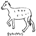 There was once a little animal No bigger than a fox, And on five toes he scampered Over Tertiary rocks. |
It has often been said that from the point of view of the geologist there is little distinction between the Great Ice Age and the Recent Epoch, the Age of Man. The former ended in the United States when the last continental glacier in its northward retreat, about 35,000 years ago, abandoned the United States. When we can gather more evidences of carbonized vegetation, possibly further search may reveal specimens beneath the contacts of the dacite flow of Llao Rock and the glaciated base on which it rests, we shall be able to tell with greater accuracy the approximate age of the entombment.
It is quite evident that the destruction of Mount Mazama occurred quite recently, speaking in geological terms, and the sculpturing process is still actively being carried on. From year to year hug spawls of rock tumble into the lake. One day last week a rock slide occurred along the face of Cloud Cap and the dust continued to rise along the talus slope for nearly two hours. This season a huge fragment broke from the extreme west end of the Phantom Ship, thereby making more slender one of the spars of The Ship.
It is apparent that the several carbonized logs are but preservation of pre-existing life and consequently can be called fossils. Fossils are they symbols in which the history of the world’s life is written, an a knowledge of the symbols is necessary before the story can be read. Animals and plants that lived long ago were buried in mud in sedimentary regions or in ash in volcanic regions just as those of today are being so buried in some places. The mud hardened to rock or the ash became indurated and then subsequent layers have been worn away as the mountain has been eroded by the action of wind, water and ice, and there is good probability that subsequent discovery will reveal the remains of animal or plants which were entombed in Tertiary or Pleistocene time. May we have additional discoveries. Who knew, but there is buried in the volcanic ash and pumice the bones of a Tertiary horse? It certainly would be a great pleasure to find the bones turned to stone of say the four-toed horses (Eohippus) or the early three-toed horses (Mesohippus) or the later three-toed horses (Merychippus) or the one-toed(Equus). If any of the above should happen to be found we would have the fossil index to the Eocene, Oligocene or Miocene epochs of the Tertiary Period of geological time and to the Pleistocene and Recent epochs — in case the find should happen to be a one-toed horse.
There have been fossil bones of the early horse discovered to the north and east of this region. Of course it is very doubtful if we ever will find the bones of such previous life in the vicinity of Crater Lake since it is apparent that the heat was so great and very probably organic material would have been consumed by the excessive heat.
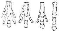 Principal stages in the development of the forefoot of the horse. |
1 – Four-toed horse (Eohippus) – Eocene Epoch 2 – Early three-toed horse (Mesohippus) – Oligocene Epoch 3 – Later three-toed horse (Merychippus) – Miocene Epoch 4 – One-toed horse (Equus) – Pleistocene and Recent Epochs |
A Butterfly Pilgrimage
By Lincoln Constance, Ranger-Naturalist
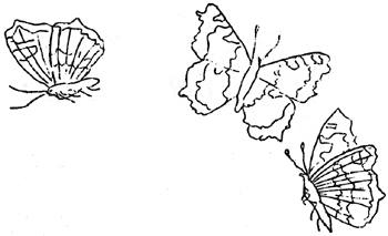
Crater Lake is experiencing a migration of butterflies resembling the flights of locusts which perturbed the Pharaohs of Egypt in ancient times. About the South Rim one encounters hundreds of these insects, but on Garfield and Scott Peaks one may see thousands and tens of thousands, and multitudes are reported to be on the wing elsewhere.
They seem to fly from all directions, headed for everywhere at once, like a confused whirl-wind. Most of them, however, cross the Lake from the north, perhaps in anticipation of a pleasant winter in California, but many are enamoured by the beauty of Crater Lake, and fly around the Rim. When automobiles arrive, the front of their radiators are lavishly decorated with the mottled orange wings of these butterflies.
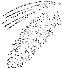
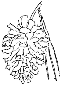
The great majority of these insects are the California Tortoise-shell Butterflies (Aglais californica Bdv.), whose wings are brilliant orange within, but grayish-brown on the outer surfaces. When they settle upon a tree trunk, or a stone, or a stray Ranger, they close their wings, and become very inconspicuous, safe in their protective camouflage. But the instant the wings are opened, the momentary concealment vanishes completely. It seems to be a conception of wide popularity that butterflies live for only a few days at best, but these insects refute that theory, and actually hibernate over the winter! The black, velvety caterpillars feed on various species of the Mountain or California Lilac(Ceanothus), which locally pass under the names of Snowbrush, Deerbrush or Buckbrush. A few whiter butterflies: Pine Whites (Neophasia monapia F. & F.), and Parassians (Parnassus clodius Mon.) are mingled with them, perhaps also succumbing to the vagrant urge.
The cause and destination of migratory movement has served tourists, and even newspapers, with much food for conjecture and speculation. J. A. Comstock, in his “Butterflies of California”, explains the phenomenon as follows:
“It is not the response to an instinct that prompts a southward movement in the fall for the purpose of overwintering in favorable environment, but rather is determined by the scarcity of food-plant, and perhaps to some extent by the sudden subsidence of the several parasites… When conditions are right for the production of swarms of this butterfly it is noted that the Ceanothus bushes are entirely defoliated over great stretches of territory in our mountains. The butterflies are compelled to move on to other districts in order to find sufficient food-plant on which to lay their eggs. We do not know factors that determine the direction of this movement. Possibly it is related to the prevailing direction of the wind since it is easier for butterflies to fly against the wind than with it.”
Tragedy lurks everywhere in the path of the voyagers. Automobiles and careless pedestrians take a heavy toll, but many more drop too near the water, and are drawn to its glassy, treacherous surface. While this may be a calamity to the butterflies, the fish appear to appreciate the addition to their staple diet, and may frequently be seen jumping for a highly ornamented, tasty morsel.
Another Important Relic
By Earl U. Homuth, Ranger-Naturalist
After resting concealed among the rocks on the shore of Wizard Island for forty-six years, the sounding apparatus used in determining the depths in Crater Lake has recently been discovered. This relic, one of the most valuable and interesting which could possibly be added to the rapidly growing collection to be installed in the exhibit room of the Memorial Lookout, is on display at the Information Bureau on the Rim.
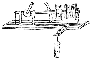
With the assistance of William G. Steel, who made the soundings in 1886, the apparatus has been reassembled. When in that year the Geological Survey sent a field party to prepare a map of the region and to sound the Lake, Mr. Steel was commissioned to have a boat constructed and to procure or build the sounding apparatus. From descriptions of such instruments Mr. Steel devised the apparatus subsequently used.
The machine consists of two wooden drums mounted upon an iron bar which was revolved by a short handle with two cog-wheels connecting to the bar. This was fastened by four iron bars to a plank forty-six inches long. The plank and drums are weathered and the iron very much rusted, and yet in remarkable state of preservation.
The drums are ten inches in diameter. One is seven inches wide and the rusted wire is still tightly wound around it. The other is four inches in width and was used as a brake to prevent the sounding weight from dropping too rapidly. The leather strap used on this drum is still attached to the plank. Two small pulleys over which the wire passed from the drum were also found. A small piece of leather may be seen attached to the wire. To facilitate the reading of the depths as they were determined, these thongs had been fastened at fifty foot intervals; at each hundred feet, up to five hundred, notches had been cut in the leather, and for each five hundred feet, holes had been punched. Actual measurements were made of the length of wire between these thongs when each depth was determined.
According to Mr. Steel, the machine was placed across the center of the Cleetwood, the boat used in the soundings. The boat was 26 feet in length and 5 feet, 10 inches beam. From the center of either side of the boat planks were fastened which were joined over the prow forming a triangular brace. On the point was placed a pulley of lignum sitae over which the wire from the machine dropped to the water.
Mr. Steel had procured ten thousand feet of wire and several window sash weights. The sash-weights were too heavy, however, and twice broke the wire carrying away sixteen hundred feet on two occasions. The weights used were cut in half and later in quarters and finally a piece of iron pipe eight inches long was used. This piece of pipe was still attached to the wire when the relic was discovered.
Mr. Steel, personally, was in charge of the soundings. The field party was under the direction of Capt. Clarence E. Dutton and Mark Kerr was Chief topographer. A group of men were detailed to the summit of the peak subsequently called The Watchman, and another group upon the eastern lakeshore. The weight was allowed to sink slowly until bottom was reached. It was then pulled up a short distance and allowed to touch bottom again. With a large flag Mr. Steel then signaled the men stationed on the shore, and they in turn drew lines upon their maps, passing on the position of the boat. In the evening these results were compared and when the lines crossed for each respective sounding the figures were entered upon the charts. Ninety-four soundings were made, the work requiring nearly one month. These are recorded upon the topographic maps used today. The greatest depth found was 1996 feet.
When the work was completed the apparatus was removed from the boat and left on Wizard Island where it has remained for forty-six years. The Cleetwood was sunk in a shallow bay of the island and the remains still lie where they were left.
Early this season the tiller and a portion of the prow were salvaged from the wreckage.
This past week Senior Naturalist and Forester Ansel F. Hall, while engaged in the work of laying out the new trail on Wizard Island, discovered the window weights which were originally used with the sounding apparatus. They were resting on the rugged lava blocks about 25 feet above the present water level. Nearby was found the wreckage of the Cleetwood, resting in a pool that is detached from the main body of the lake; the level of the lake being exceedingly low. The oar locks were found and along with the weights they will be place on display with the sounding apparatus.
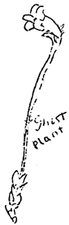
Ghost Plants
By Lincoln Constance, Ranger-Naturalist
In the deep forests of Crater Lake there grow a number of oddly-colored, leafless plants, which look like phantoms in the shadows. Their secretiveness betrays that they are bent upon no honest business, and they are, indeed, the robbers of the plant kingdom. Possessing no leaves of their own with which to manufacture food, they prey upon their more industrious neighbors, or live ghoulishly upon the decaying vegetation.
Most of the leafless plants are members of the Heath Family, which includes such common plants as the Manzanitas, the Heathers, the Rhododendrons, and the Madrone, beside their degenerate kin. The “Stick-candy” (Allotropa virgata) is very noticeable by virtue of its red and white stripped stem, bearing a dense spike of flowers of the same colors. It looks like nothing in the world so much as a barber pole, whose gaudy lines have been straightened out, and set vertically.
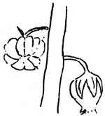
A close but less gaudy relative of the stick-candy is the “Pine Drops” (Pterospora andromedea). Again we find an erect plant, surmounted by a dense spike of flowers, but this plant varies from tawny to red, and is completely covered with short sticky hairs. The flowers are myriads of little silent bells, which might have been grafted on from some Manzanita or Heather. While the Stick-candy seldom reaches more than a foot in height, the Pine Drops may ascend as much as three or four feet.
The “Pine Sap” is a smooth, fleshy little plant, colored red, yellow or orange, an bearing a raceme of beautiful, waxy flowers of the same hue. It is only two or three inches high, but its brilliant yellow or red tones render it quite conspicuous when one does chance upon it. The Pine Sap is closely related to the “Indian Pipe”, which bears a number of pure white, one-flowered shoots in dense clusters, and is quite common elsewhere in the state, but is apparently not found in the Park.
That most aristocratic family of flowers, the Orchid Family, also contributes two of its black-sheep to this eerie group. These are the “Coral-roots”, which are probably the most common and conspicuous members of this band. The “Merten’s Coral-root” (Corallorhiza mertensiana) is a rich brownish-purple spire, studded with flowers or the typical Orchid form. The “Spotted Coral-root” (Corallorhiza maculata) is usually lighter in color, affecting a yellowish brown, and its flowers each bear a white lip, spattered with irregular purple blotches. These orchids live upon decaying humus, and to utilize it most effectively, they have developed a much-branched system of fleshy roots, simulating a heap of interwoven grey coral.
Growing among the Stone-crops, or sedums, in the crevices of the rocks, little tubular, violet-tinged flowers may sometimes be discovered. The stalks are yellowish, and a few shriveled bracts are all the remain of the green leaves that may have adorned and nourished them before they strayed from the unattractive path of independence. This is the “One-flowered Broom-rape” (Thalesia uniflora), which is an out-and-out parasite, and must derive all its nourishment at the expense of its more self-reliant neighbors.
Since most of these plants have relatives who can, and do, manufacture their own food, it is probable that these phantom flowers also once lived entirely by their own industry. But the competition for light and air was too keen in the deep arboreal shade, so they resorted to trickery. Their wiles proved effective, and they throve, but the stump of the flabby parasite is upon them, and they have lost forever the ability to produce green leaves and live self-reliantly.
Bobby Learns to Trust Nobody
Bobby, our little golden mantled squirrel, which has made her house under the so-called Information Bureau, the building now used as the Educational Headquarters, had a very harrowing experience some three weeks ago. She had come to trust the rangers and our park visitors, and it was with a misguided sense of safety, that she would flit with a deft hop, skip and jump to take the niceties offered and fill to capacity the pouches in the sides of her face. She would carry these supplies for the coming winter to her home under the floor of the building.
About three weeks ago in a trusting and good-natured manner she was attracted by some of our park visitors who evidently had not read the park regulations concerning the capture and removal of the wild life. The capturers enticed Bobby into a paper bag containing salted peanuts and then quickly placed the bag in a tin bucket. The lid on the bucket had been punctured to permit air to enter the prison. It is quite evident that the intended capture of a squirrel or chipmunk had been deliberately planned.
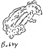
One of the Oregon University football players who is employed at the park this summer and is incidentally securing a swarthy coat of tan and developing bulging muscles for the coming football season, seeing the impending catastrophe, hurriedly rushed into the Naturalist’s office and exclaimed: “Someone is attempting to steal Bobby, they have her in a car and are just ready to drive off!” The Park Naturalist immediately went to Bobby’s rescue, suggesting that such action just was not done and that other visitors would come from day to day who would also enjoy the frugal activity and antics of the golden mantle squirrel along the rim and that Bobby must be released. The admonition was given with that playful smile which saves a deal of hard luck and the would be captors of Bobby, the tailless one, somewhat reluctantly to be sure, released our pet and now there is another tail about Bobby.
For several days after this unfortunate episode Bobby was not seen. She probably remained at home and recovered from her nerve-wracking experience, but gradually she regained her and now can again be seen scampering merrily around the rim wall and taking bits of food offered her.
Last year the readers of Nature Notes will recall how we considered changing her name from Bobby to Roberta when she brought out, from the security of her basement home, five beautiful little squirrels for our consternation and approval.
So Bobby is now a privileged squirrel; her faith in humans is being gradually restored and again we find her in and about the Information Bureau. The Naturalists of the Educational Staff have vowed that in case some misguided visitor again attempts to capture any one of our animals inhabitating the park, the culprit will be thrown into the blue depths of Crater Lake hoping that the offenders will be devoured by some of the legendary Indian Gods.
How to Know the Pines
We are fortunate at Crater Lake National Park in having a very representative collection of coniferous (cone-bearing) trees: pines, hemlocks, spruces, and firs. Most of the park area, except for the pumice flats, and exposed rock masses, is covered by these evergreens, which clothe the barren slopes of ash and lava with a perpetual mantle of pleasing verdure. Even such cinder cones as Wizard Island and Timber Crater are ornamented with forests.
The pines are not only easy to tell from all other trees, — they are our only conifers which bear their needles in cluster — but are readily distinguishable one from another. In addition, they are fairly well segregated as to altitude, and serve as “Zone Indicators”. We find that plant and animal life varies with the altitude, and that in ascending a mountain we pass through definite layers of living things, termed “Life Zones”. Some plants and animals are limited to a definite band, and occur almost universally throughout it. By learning to know a few such forms, we can easily tell which zone we are in, and know what sort of life we may expect to see there.
The zones of altitude correspond with geographical zones, or zones of latitude, and are named for the latter, so we have the Arctic-Alpine, the Hudsonian, the Canadian, the Transition, the Sonoran Life Zone, et cetera. The further south we go, the higher we must climb to reach a given layer. At our latitude, the Hudsonian Zone is found from about six thousand feet to higher levels of the Park (less than nine thousand feet); the Canadian, from six thousand to five thousand; and the remaining area, five to four thousand feet, lies in the Dry or Arid Transition Zone. We find that the five varieties of pine native to the Park are well-distributed through these three zones.
Our pines may conveniently be divided into two groups — the white pines, and the yellow pines. The first class is characterized by bearing its needles in groups of five, and possessing a gray or whitish bark, which is either smooth or furrowed. The White-Bark Pine (Pinus albicaulis Engelm.) is the only pine found in our Hudsonian Zone. It is the common tree about the South Rim, on Cloud Cap, Garfield Peak, Scott Peak, Llao Rock and elsewhere. Growing at such a high elevation, and exposed to severe weather conditions, it is usually twisted and bent, so that its wood is of no commercial value. The cones of this tree are three inches or less in length, and oval to ovoid in shape.
In the adjacent zone, the Canadian, we find the Western White Pine (Pinus monticola Don.). This tree is common on Wizard Island, and upon the Inner Rim of the Lake. It is usually tall and straight, reaching a considerable height. The needles occur in fives, but are somewhat longer than those of the preceding tree, and do not clothe the branches so densely. The cones are six to eight inches long, and narrowly cylindrical. The White Pine produces a fine-grained white wood, which is chiefly valuable as a substitute for the Sugar Pine.
The king of the White Pines — the Sugar Pine(Pinus lambertiana Dougl.) — is an immense tree, which unfortunately, occurs but rarely in the park, and then only in the lower reaches of the Transition Zone. The needles — again in fives — are rather long, and the huge cones, thirteen to eighteen inches long, immediately distinguish it from all its lesser relatives. While very scarce in Oregon, the Sugar Pine is one of the most valuable timber trees of California, where ninety-eight per cent of that variety is manufactured. The wood is white, soft and straight-grained, and is often used for interior finish.
While passing through the lower areas of the Park, you may see a pine whose trunk resembles a stately bronze column. The coppery bark is usually broken up into rectangular patches, which scale off easily. This is the Western Yellow Pine (Pinus ponderosa Dougl.), the only tree in the park which bears its needles in groups of three. Like the Sugar Pine, it occurs only in the Transition Zone, and serves as an indicator throughout the Cascades and Sierra Nevada. The cones are three to five inches long, oval to globular, and beset with prickly points. Although it produces a soft, somewhat resinous wood, it is very highly regarded as a source of cheap lumber.
The Lodge-pole Pine (Pinus contorta Dougl. var.marrayana Englem.) is a slender tree, growing in dense stands throughout the Canadian Zone, as about Park Headquarters. It has a thin, dark-colored, smoothish bark, which is easily penetrable, and as a result the Mountain Pine Beetle (Dendroctonus monticola Hopk.) makes it chief ravages against this species. The “Ghost” of “Silver Forests” towards Diamond Lake are largely stands of the Lodge-pole Pine, which have fallen a prey to this vicious pest. The cones are small, oval and prickly, and the needles are borne if fascicles of two. The low, twisted Beach Pine (Pinus contorta Dougl.), found only at sea level, is frequently considered to be a low altitude form of the Lodge-pole, but the great variance in general aspect make it seem quite likely that the two should be regarded as distinct species. For some reason, the Lodge-pole Pine locally passes under the name of “Tamarack”, but this is entirely erroneous, for it has no close relationship with the true, Swamp-growing, deciduous Tamarack (Larix species) of the Eastern United States.
“By the needles ye shall know them!” might be our watchword in telling the pines apart. The number of leaves in a cluster, the size and shape of the cones, the color of the bark, and the altitude at which the trees grow give us a series of clues to their identity. After you have examined the cones and needles of each a few times, the general shape, size, and aspect of the trees will enable you to recognize the five types, as you merely drive through the forests.
The Rim Canyon
This year there has been added to the guide trips of the Naturalist Service a conducted caravan tour around the Rim Road which encircles Crater Lake. Each morning the visitors wishing to take the caravan tour assemble at 8:30 around the parapet of the Sinnott Memorial Building, where a member of the Naturalist Staff explains the points of interest around the Lake. Then the visitors go up to the highway and take their machines for the drive.
From eight to ten stops are made on the tour, with the Naturalist in charge taking the party to study the features in place, with the various phenomena of the Rim region constituting a marvelous practical laboratory. The natural features around the Rim Drive portray a manifold works of “The Master Teacher – Nature” and the exhibits in-situ constitute “The Supreme Text Book.”
Stops on the caravan tour are made as a rule at the following places: the South Base of Hillman Peak, affording a marvelous view of Wizard Island and the narrows of Skell’s Channel; the north base of Hillman in which the marvelous panorama of Mt. Bailey, Diamond Lake, Diamond Peak, Red Cone, Pumice Desert and Mt. Thielsen are spread out in remarkable clarity. The tremendous dike, the Devils’ Backbone is visited and the more venturesome in each party get the exquisite thrill of leaning over the very crest and looking down upon the lake. The glacial polish, chatter mark and striae, showing us the sculpturing action the work ice played in developing the present configuration of the rim slopes are visited. The stop at the North Entrance Ranger Station offers an opportunity to observe the contact of the lava flow of Llao Rock and its base, a glacial valley. The splendid portrayal of vegetative life zones is well shown at many places on the drive, particularly around the base of Llao Rock and on the way to Mazama Rock, where fractured surfaces show shearing and slicken-slide activity.
The caravan does not stop at Pumice Point, Palisade Point or the Wine Glass but the visitors have the opportunity of splendid views of the lake surface and Rim Area from these places as they drive along.
Skell Head affords a marvelous view, one that is equally entrancing regardless as to whether the time is early in the morning with oblique rays to the observers back, midday with marvelous reflections appearing around the north side of the Rim, or late in the afternoon with the beautiful colors of a receding sun tinting the panorama. Cloud Cap is another point of vantage for the caravan to pause and there get the first vivid pictures of the Phantom Ship. Probably the most impressive view of the entire tour is obtained by those who make the climb down to Sentinel Point. The Red Castle Formation, along the side of Cloud Cap with its turreted forms of variegated colors, are visible as well as the Phantom Ship, Dutton Cliff, Applegate and Garfield Peaks as well as Kerr and Sun Notches.
The last stop on the caravan tour at Kerr Notch affords the intriguing view of “The Ship” and then the group proceeds at their own leisure.
Wizard Island Exploration
This season we have inaugurated a visitation to Wizard Island under the guidance of a Naturalist. The Cinder Cone is ascended, the crater explored and then, after the descent, the party goes out over a new trail on the rugged cinder slope and when the trail is extended a visit to the fascinating Witch’s Pool will be made. The visitors making the trip to Wizard Island also make connections with the last boat in the afternoon which reverses the normal course and picks up the ones who have explored the island to take them through Skell’s Channel, close to the base of the Devil’s Backbone, and across the center of the lake to the Phantom Ship.
The guide trips of previous years, the Rim Walk and the Garfield Hike are also being enjoyed by many.
Other pages in this section