

Volume 7 No. 3 – September 1, 1934All material courtesy of the National Park Service. These publications can also be found at http://npshistory.com/Nature Notes is produced by the National Park Service. © 1934 |
A Story of Mount Mazama
By Warren D. Smith, Ranger-Naturalist
John Wesley Hillman discovered Crater Lake in 1853, but it remained for the late J. S. Diller and Major C. E. Dutton of the United States Geological Survey to discover Mt. Mazama. These two men by their laborious and careful work toward the latter part of the past century reconstructed this pre-historic mountain so faithfully that with only minor additional observations we are able to place before even the most casual visitor a most real picture of this old monarch of the Cascades.
Looking to the north and south from our vantage point we see the broad platform of the Cascades on which Mt. Mazama, Shasta, Three Sisters, Jefferson, and Hood rise as superstructures. All of these mountains, with the exception of Mazama, are relatively intact and except for some ice, water, and wind erosion effects they maintain some semblance of their former outlines. Not so Mazama. Its whole upper portion is missing. To reconstruct its former condition, we must note first of all that its history of building was one dominantly of explosive activity which would of necessity produce a conical shaped mountain and not a low lava dome. Second, its backslopes, which one can see at many points on the Rim Drive, indicate how the curve of these slopes would go if projected upward, and last, the size of its base, which can be measured, will give one a clue as to its magnitude in comparison with other Cascade mountains. By putting together all the observations of the inner and outer parts of the present crater one can bring out the main steps in the history of this old mountain. In doing this we should call attention to the:
- Materials – composition, distribution, texture.
- Profiles – That is, the importance of geological line or pattern which may have entirely different meanings from those the artist sees.
- The factor of time; not actual but the relative ages of materials and happenings.
It is very likely that Mt. Mazama started out very much as Wizard Island did, i.e. as most volcanoes do, as a small cone on this Cascade plateau that grew larger and larger literally by “fits and starts”. There would be a time of quiet upwelling and outpouring of lava to be followed by great paroxysms of violent explosions. This is not a matter of conjecture, for the crater walls carry the inescapable record. There are periods, too, of quiescence when the slopes of the mountain at different stages were forest covered and long erosion intervals occurred.
Geologists and others, who came long after Diller and Dutton, have dug into the crater walls and found beneath sixty feet of debris portions of old charred stumps and logs. The long erosion intervals when valleys were cut in the old lava slopes are proved in many places by the unconformities where valley profiles cut across lava flows and beds of fragmental materials. One such unconformity is remarkably well exhibited in Red Cloud Cliffs where a V-shaped valley was cut by stream action and not ice in the nearly horizontal (as seen in section) lava flows and later filled by a solid flow of lava.
There were also other events of importance in the life history of the old volcano quite different from its episode of igneous (fire-born) action, such as the accumulation of great snow fields on the highest slopes and streams of ice fed by these fields of nevé coursing far down the lower slopes. The records of these are found on all sides of the present crater, both inside and outside the present rim. These records are of three kinds: U-shaped valleys, like Kerr and Sun Notches; glacial scratches like those at Discovery Point, on the north rim between Watchman and Llao Rock and on the Watchman itself; and moraines, at many points on the rim, especially at the heads of Munson and Castle Creeks. Records of at least two and perhaps three separate periods of glaciation may be noted in the study of the crater and its back slopes. In this connection it may be pointed out that it is not at all improbable that some glaciation occurred after the destruction of the main mountain and that this catastrophe took place in the last inter-glacial epoch which, if true, would enable us to date this cataclysmic event to about 15,000 – 20,000 years ago.
In trying to get some conception of the height and shape of old Mount Mazama, we are aided by the knowledge that mountains of the explosive type (which is the rule on the Pacific rim) the slopes follow approximately the sine curve. Bearing all these facts in mind Diller restored old Mazama to a height of approximately 15000 ft. in elevation. With a height of 15000 feet and a circumference of 27 miles at the present rim elevation of 7000 feet we would have a volcano here in former times comparable to Mt. Shasta today.
Having built our old mountain up to its full height we are now ready to decipher the next chapter in its history which was one of destruction rather than that of construction. That something of tremendous consequences and involving forces of unbelievable magnitude were at work here is evident even to those least versed in geological force. But just exactly what and how it happened is not so easy to decide. We know that a mountain mass of approximately 15 cubic miles above the present rim towered up into the blue, also that the present crater contained another mass of material altogether totally some 17 cu. miles of rock and now all this is gone. Here comes the rub, for many competent geologists do not agree as to just what did transpire, like doctors who often disagree as to just of what ails a patient. If doctors disagree, it may be “just too bad” for the sick one, but in this case the patient was old Mazama, and apparently the old fellow is quite dead, and therefore it hardly seems a vital matter to decide how it happened. Why worry our heads about theories? Why destroy the mystery? Let old Mazama rest in peace with its present beauty, and let us be content to enjoy the great spectacle.
This would be all right with most people, but geologists are curious people, perhaps overly curious, who are not satisfied with sheer beauty – they want to know and some day they will solve the mystery of the “Old Man of the Mountain”.
Now among several possible theories, we have two outstanding:
One, the theory of collapse and engulfment; the other that of explosion. Space does not permit us now to discuss the quite antagonistic points of view and furthermore the discussion would involve so much that is technical that readers of this number of Nature Notes would perhaps become weary. Suffice it to say that the trend of opinion among many geologists, among these several foreigners of note, appears to be in the directions of a modification of the older notions; that is to day, toward the theory of explosion. Several knotty points will have to be cleared up, however, before some students of the subject will be satisfied.
With due regard for the fine work in the early days by Diller and Dutton the present writer feels bound to disagree with the final interpretation of this important chapter of the geological story. On several grounds is he led to the conclusion that explosion was the dominant factor in wrecking the old mountain. In the first place, explosion and not collapse is the rule in the wrecking of volcanoes of this type, especially on the Pacific rim. Second, the amount of fragmental material scattered far and wide with Crater Lake as a center. Recent road cuts have revealed the fact that there is a veneer of pumice and “finer ejecta” that conceals much coarser fragmenta on the apparently clean back slopes of the old mountain. Third, the crater itself is a typical explosive orifice and is like that of Kilauea only in the most superficial respects. And finally, since the dominant forces in the earth are working outward, at least in connection with vulcanism, on purely mechanical grounds collapse of a great mass when so much material has been previously extruded violently does not seem to be reasonable.
After the formation of the Crater, by whatever process, the volcanic energy was not altogether spent, since three new baby ones were built up within the wreck of the old one. And no like a giant of old, with the geological vultures of erosion gnawing at its vitals, it lies, enchained. What if some day it lifts its new head of Wizard Island higher and roars again its defiance!
The Waters of Crater Lake
By J. Stanley Brode, Ranger-Naturalist
The geologist has told the story of Mount Mazama. The mountain has been built up and destroyed, and in that great rent a second volcano appeared. Still more recently a lake has formed. How long has Crater Lake existed? Wizard Island has on its shoulder a mantle of tree life. The trees now there are the first it has borne. By borings and ring counts made by Dr. W. G. Vinal in 1933 the age of the trees was studied and some were found to be over 790 years old. Observations made by scientists and laymen on the slopes of Krakatoa and Katmai indicate that only a few years elapse after eruptions until the volcanic slopes are covered with plant life. This would place the probable cessation of volcanic activity on Wizard Island some 900 to 1200 years ago. Geologists tell us that the rocks do not show characteristics of lava that has flowed into or through water. This leads us to believe that the lake is younger than the island. The lake is probably well under a thousand years old.
In estimating the time required for the lake to fill the caldera or crater to its present level we have four factors to consider: (1) the volume to be filled; (2) the precipitation and drainage into the lake; (3) evaporation from drainage area; (4) seepage through crater walls. From the geological and engineering date we get the following significant figures:
Total area within the Rim – – – – – – – – – 27.48 Sq. Mi.
Area of water surface – – – – – – – – – – – 20.42 Sq. Mi.
Average depth of lake – – – – – – – – – – – 1500 feet
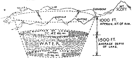
(1) Volume. According to the geologist the hollow in which the lake lies is in the general shape of a truncated cone. Arbitrarily estimating the average height of the rim at 1000 feet above the lake surface with an area within the crater rim of 27 square miles, and the lake surface, with its area of 20 square miles, a plane parallel to the base of the cone, we assume the bottom of the lake to be another plane parallel to the base of the cone and at an average depth of 1500 feet. From this we figure the area of the lake bottom to be nearly 10 square miles. From these figures we estimate the volume of water in the lake at present as about 416 billion cubic feet or 2.82 cubic miles.
(2) Precipitation. The average annual precipitation at the lake is given as 70 inches, most of it in the form of snow, 80 to 100 feet falling at the rim. Over a drainage area of 27 square miles this precipitation would yield 3,885 million cubic feet of water a year, which, if there were no evaporation or seepage to consider, would fill the lake up to its 1908 level in a little over 107 years.
(3) Evaporation. One estimate gives the evaporation from the lake area as 55 inches. While another gives it as 46 inches. Calling the average 50 inches, the effective precipitation available to fill the lake is reduced to 20 inches, which, ignoring seepage, would have filled the lake at a rate of 1,100 million cubic feet a year and would have required 365 years to fill it to its 1908 level.
(4) Seepage. At the present time a balance has been reached between precipitation on the one hand and evaporation and seepage on the other hand, and since the evaporation is approximately 50 inches there remains 20 inches of precipitation lost to be accounted for by seepage. The seepage factor has perhaps been the factor that has checked lake level rise. When the lake began to fill the crater there was doubtless but little seepage. Presuming that over the period of filling the amount of seepage has gone from 0 to 20 inches, we take the average, or 10 inches, as being the average amount of precipitation lost by seepage. That leaves 10 inches as the average effective annual increase deposited in the lake, or 555 million cubic feet a year. At this rate it would have required 730 years to fill the lake, presuming that rainfall and evaporation rates to have averaged as in the past fifty years.
Quatrains of Crater Lake: Night on the Lake
By Ernest G. Moll, Ranger-Naturalist
Man is too frail to speak the power of this
Mysterious night or plunge with thought the gloom
Where Cloudcap hangs above the vast abyss
Tremendous in his shadow-robes of doom.
The Lake
By Ernest G. Moll, Ranger-Naturalist
We sit on the rim looking at the lake that lies a thousand feet below us. The morning is clear and windless with a touch of autumn in the air. Blue the lake lies, blue and calm as a great morning-glory fresh with the dews of night. And above it the walls rise, towering in places to a height of two thousand feet above the water, the western areas bathed in strong sunlight, the eastern cliffs veiled in mystery-making shadows. The great stone breast of Llao takes the morning: opposite, Cloudcap looms gloomily. On the tip of Wizard Island the sunlight glows, and at its base the waters sparkle as they break.
For awhile we sit without thought, the mind making no inquiry, only our senses and emotions awake and active. Trite as the phrase may be, this experience comes to us like a draught of wine “cooled a long age in the deep-delved earth.” At first we know only the taste, the smooth matchless flavor, the sweet that has in it little glinting edges of sharpness. Then little by little we think of the rain and sunshine from whence this vintage came, and the slopes of the hills with the green vines on them, and blue skies and summer and the voices of harvesters. So it is as we stand above this lake. After the first impressions of color and form, silence and far cool shadows – after, shall we call it, this feast of the senses – there float up into the mind questions that will not be still till we have made them welcome and satisfied them with thought. For man – and it is not the least of his attributes – would know as well as see and feel. What, then, does it all mean, this “silent sea”, these majestic cliffs, this ceaseless play of light and shadow?
In fancy we call to our side a young brave of the Klamaths, bronze and lithe as a creature of the forest, brought back to us from the dust that is the past. He glances down the crater walls to the quiet water, then turns his back to the lake and stands, arms folded across his chest gazing steadfastly out through the clustered hemlocks, out and on to the wide valley that lies beyond the mountains. Why does he bend his eyes away, why turn his back on this which holds our vision captive?
Llao, he is thinking of, and Skell; the one mighty and evil, the other mighty and good. Through his mind troop in pageant the legends of his folk, the wonderful old story of the Indian maiden and the great god Llao who loved her and desired to carry her to his home in the burning mountain, down to his kingdom of darkness and fire. He is thinking of Skell, the god of things above ground, who loved the maiden also, and of how Llao, his passion thwarted, rushed back in anger to his burning mountain, and Skell, his love disappointed likewise, went away quietly with peace in his heart and kindness on his lips. He is living again the long war of the gods that followed, when Llao in his rage hurled up the yellow water-smoke and the flaming stones that killed many men in the valley and filled the villages with wailing. He is thinking of the four wise-men who went softly and bravely into the horrible regions of Llao, giving themselves as sacrifices that peace might come, went with their torches growing dimmer as they night closed about them, went and never returned. And in time Skell killed Llao, and Snaith put out with his rain and snow the last fires of the evil one, and peace settled over the broken walls of the mountain.
So dreams our brave, his back to the lake, his face to the valley, and in his dream we later sons of earth find more than simple legend. This vision is truth as seen by the imagination, an explanation, in fact, of the destruction of Mount Mazama and the creation of the lake within its hollow and shattered walls. And it is more than that. In the story of the strife between Llao and Skell we have the old problem of good and evil, of love and hatred, of gentleness and anger. The good, it is worth observing, triumphs, but in that triumph there is no rejoicing. Our brave stands in solemn silence, for the thing on which he has just looked is a tragic thing. Llao, with all his faults, was mighty and magnificent, and the ruins of the mountain that was his throne are majestic ruins.
And now, still searching for meaning, still weighing the questions that have risen in our minds, we call to our side a man of our own generation, a scientist. His words are not those of the Klamath brave, yet the story which unfolds is not unlike the earlier one. He, too, tells of water-smoke and burning rocks, and we of ourselves can call up a vision of men in the valleys turning their faces away from the horror among the hills. The strife he pictures is less human, less personal, but clearly in the forces of creation and destruction, forever locked in war, we can read the Indian’s concept of good and evil eternally in conflict. The scientist too pictures for us a noble mountain and from his words and from the ruins at our feet we piece together again the tragic story of its destruction.
The Klamath brave is gone, the words of the scientist grow faint in our ears. Before us lies the lake, calm in the vast shadow of time that glooms over it, majestic beyond the highest dream of man, mysterious, beautiful with life, terrible with death. And its meaning? That no man shall ever voice completely – only a few broken phrases of it:
Time shuts the old earth-giants all away
In cool far dungeons where his years lie deep,
But rarely does he grant, as here, to play
Smiles that light with loveliness their sleep.
A Rebellious Nuthatch
By Craig Thomas, Ranger-Naturalist
I had watched a number of interesting birds on Wizard Island and they all seemed to be behaving themselves as they should, when a nasal “yenk, yenk-yenk” reached me as I went along the trail. When I first saw him, he was perched on the tip of a dead limb. That in itself was nothing to get excited about.
Nuthatches have a habit of sitting in positions and on places that Nuthatches shouldn’t, but this one went the whole family one better. Suddenly on his absurd little wings he fluttered valiantly out into the air-lane of insect aviators that swept down a current of wind between the trees. He did a couple of somersaults, almost flew on his back, his tiny wings beating frantically, and then returned to his lookout station looking very pleased with himself.
Now, if he had done that once, and then gone on about his business, I should have thought nothing about it. But he left his perch to repeat the performance a number of times. An Olive-sided Flycatcher nearby, looked, I thought, aghast at such a performance, which obviously was the sole property and copyright of the Flycatchers. Finally, as so many of us do, this little fellow got all his wild oats out of his system and hurried efficiently about his neglected business as though it had never entered his head to rebel at the customs of his people or to break the conventions handed down by his tribe.
Quatrains of Crater Lake: Hemlocks
By Ernst G. Moll, Ranger-Naturalist
Serene where death once pitched his camp, they lift
Green spires against blue water far below;
And the scarred slopes where their slow shadows drift
Drink the cool peace that only trees bestow.
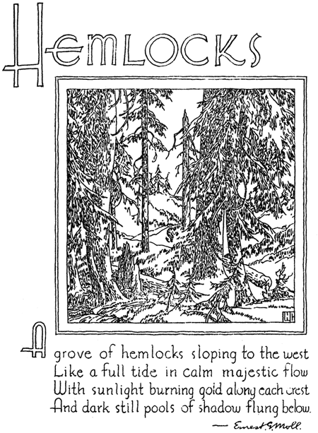
Drawing by Walter Rivers.
Speculation on Specularite
By Carl R. Swartzlow, Ranger-Naturalist
On the walk to Sinnott Memorial, about halfway down the last flight of steps, there is a boulder showing mineralization. The boulder is on the outside retaining wall, and along its top surface are streaks of specularite (ferric iron oxide) and small quantities of some other mineral. A high power microscope would be necessary to determine their identity. The presence of these materials proves the presence of mineralized waters or gases emanating from fissures on Mt. Mazama. Very few secondary minerals have been reported from the rocks of Crater Lake and each new discovery may help unravel the story of the type of magma that supplied the lavas of this region.
The Phantom Ship Loses a Sail
By Hugh H. Waesche, Ranger-Naturalist
The Phantom Ship is one of the most popular of Crater Lake’s many novel objects of beauty. Geologically, the Phantom Ship is a remnant of a projecting promontory of the Lake rim, left by natural erosional forces. It is separated from the mainland by a shallow channel of several hundred feet. As is the case with all earth features produced by the erosive action of water, wind, and ice, the Phantom Ship is doomed eventually to disappear from view.
The lava rocks of this “Ship” are like the others of the Crater Lake region in that they are much fractured by jointing. The joints give ready access to plants, rain, and ice, and promote unequal expansion of the rocks caused by changes of temperature. At the “bow” (southwest) end of the Phantom Ship are several comparatively small spires of rock, succeeded towards the “stern” by the tall pinnacles which rise high above the water, simulating the masts of a sailing ship. On July 25, 1934, between two and four o’clock in the afternoon the second of the smaller spires fell from its place into the lake carrying tons of rock from the side of the “Ship” with it. The evidence of this is shown by the absence of the spire and by a clean gray area of exposed new accumulation of talus at the water’s edge. It may have been caused by unequal expansion of the rock during the warm weather of the week of July 25.
A Water Ouzel Inside the Rim
By Berry Campbell, Ranger-Naturalist
The Water Ouzel (Cinclus mexicanus) is fairly common in the streams which flow off the sides of the old Mt. Mazama. It was the writers good fortune to discover a bird of this species at the shore of the lake at the foot of Dyar Rock late in the afternoon of July 25, 1934. I was traveling along the shore by rowboat, and saw the bird at the foot of one of the numerous spring-fed streams which cascade into the lake in that vicinity. This species has a predilection for water falls and the small trickle down the cliff walls seems to have been the attraction. I rowed up in the boat to get a better view of it and it flew around the next point. Sure enough, when I followed it around the point, I found that it had settled on a rock at the next waterfall, and there it stood, bobbing up and down, watching me as I rowed slowly off down the lake.
Applegate’s Paint-brush on Applegate Peak
By Elmer I. Applegate, Ranger-Naturalist
Last winter at Stanford University, while preparing labels for my 1933 collection of Crater lake plants, I was struck by the unusual repetition of a name on one of them. The label reads something like this:
Name of plant: Castilleja Applegatei. Locality: Applegate Peak. Collector: Elmer I. Applegate.
The plant was named for me by Dr. M. L. Fernald of the Gray Herbarium, Harvard University, based upon a collection made by me on the summit of Mount Scott, in August, 1896.
To complete the story, I might add that Mount Scott was named for Levi Scott, a member of my grandfather Applegate’s expedition in the initial exploration of southern Oregon and the blazing of the Applegate Trail in 1846.
An Oregon Jay Gets a Thrill
By J. Stanley Brode, Ranger-Naturalist
On August 20 an Oregon Jay attempting to light on the ridgepole of our tent apparently missed his landing and lighting on the slope, continued sliding on down to the edge, where it took flight. Now, if that had occurred only once it might have been construed as an accident. But apparently they jay was as thrill hungry as the modern generation is reputed to be, for it came back to try the slide again. Three times the performance was repeated, and then our sliding jay betook himself to other means of amusement.
Quatrains of Crater Lake: Llao
By Ernest G. Moll, Ranger-Naturalist
Great bird of fire, cold now, and gray, and lone,
Ten thousand years have seen you never wake,
Ten thousand more shall know your breast of stone,
Brooding far up above the silent lake.
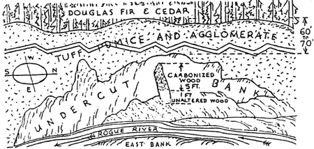
A Buried Log in Rogue River Tuffs and Agglomerates
By Warren D. Smith, Ranger-Naturalist
On July 27, 1934, Nelson Reed and the writer went down the Rogue River about one mile below where the Diamond Lake Road crosses Rogue River to investigate a newly discovered buried log site. At the place indicated, Mr. Reed had discovered a buried log in the tuff and agglomerate on the west bank of the Rogue River.
The log is of cedar, nearly three feet in diameter, with some six to eight feet exposed, standing nearly vertical, and embedded with some sixty to seventy feet of fragmental material above it. The upper part of this log is charred, while the lower one to two feet is apparently little changed; it appears that the tree was quickly entombed and hermetically sealed by hot material. This tree was evidently standing and probably alive and flourishing when the explosive material was thrown out, and the blast seems to have pushed the tree down the slope at an angle of 74° away from the center of disturbance. This find ties up very well with the discovery made by Mr. D. S. Libbey farther east on the Diamond Lake Road, but in this find we have a standing, instead of prone log. Furthermore, this tree bole is only partly carbonized.
Specimens of the unaltered wood from this tree were submitted to Doctor E. I. Applegate, Ranger-Naturalist, and Mr. Shirley Allen of the United States Forest Service and both pronounced it as “most likely” cedar. It is quite probable that much the same type of forest as is now growing there was growing in this region prior to the time of entombment of this specimen. This locality is now covered with a magnificent Douglas Fir forest in which many cedars are found.
Below is a sketch of the deposit and the long as partly exposed by the river under-cutting the bank.
Other pages in this section