

Volume 8 No. 2 – August 1, 1935All material courtesy of the National Park Service. These publications can also be found at http://npshistory.com/Nature Notes is produced by the National Park Service. © 1935 |
The Canyons of Crater Lake National Park
By Warren D. Smith, Ranger-Naturalist
Canyons, like caverns and craters of volcanoes, always intrigue the imagination. Everyone who pretends to know much of anything has, I suppose, heard of the Grand Canyon, and some have looked into its awful depths and wondered what made it, but only a few have seen the much smaller canyons of Crater Lake National Park. While not so deep or awe-inspiring, these latter, because of the materials into which the streams have carved these comparatively deep trenches, are in some ways more interesting to the geologist than is the larger one.
Most canyons have been carved by running water working through long ages. These in Crater lake Park are relatively very young.
Also, most canyons are due to streams working along pre-existing fractures in the rocks. Some are cut in sandstone and limestone — relatively soft rocks — while others are incised in hard lavas, granites, etc.
Some are somber and gray like Hell’s Canyon in the Snake River, between Oregon and Idaho, others are brilliantly colored and sculptured like the Grand Canyon, and still others are black and forbidding like the Black Canyon of the Gunnison in Colorado. Our little canyons in Crater Lake Park are light colored, in places creamy white, and not at all forbidding. In fact, in the bottom of some there are tiny little meadows and beautiful flowers and lush grass.
In this article, I shall attempt to describe some of the most striking features and important characteristics of the following: Godfrey’s Glen in Annie Creek; The Pinnacles in Sand Creek; Llao’s Hallway in Whitehorse Creek; Rogue River Canyon, which, although it lies outside the Park, is a part of the area intimately related to the Park.
If one comes into the Park from Klamath Falls up the Annie Creek Road, he will pass, for a part of the time on his left and part of the time on his right, a deep (200 – 250 feet) canyon which reaches its finest expression in what is know as Godfrey’s Glen. At a convenient point on the road one can stop his car and look down to where the canyon of Annie Creek, suddenly widening out, forms something like a deep glen. A superficial glance reveals creamy walls shading off here and there into pinkish tones or even grayish black, along a deep trench out of which tall trees barely emerge. However, a trip down to the bottom will show much more.
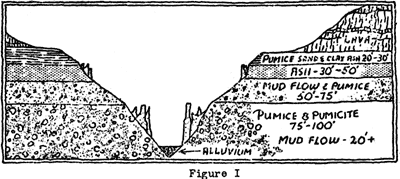
Scrambling down to the bottom and working up on one of the walls, (it is always better to work upward in such a place as one will move more slowly and therefore see more), one notes that the canyon is made up from top to bottom of loose friable materials, but of such consistency that for several miles the walls are very steep, in places almost perpendicular. A more careful examination reveals at least four distinct horizons in which the materials are different. Although practically all of the material is pyroclastic, “fire-broken” rocks, at the bottom is a bluish to reddish deposit of fragmenta. Above this lies a thick deposit of pumice and pumicite and still higher up in the steeper portion of the canyon wall is a heavy red bed of dark grayish to black volcanic ash which stand up in bold cliffs. On top we have 30 to 50 feet of loose pumice and sand with a slight mixture of clay, just enough to the material will pack somewhat when a handful of it is firmly pressed. The other materials show little tendency to do this and are very crumbly.
Just what is this deposit and how came it to be where it is? Much of the material is extremely light in weight and porous. Geologists have identified this as pumice and pumicite, which was a frothy lava of quite acid composition, i.e. high in silica, ejected from the prehistoric volcanic mountain in a violent explosion.
There is some mud flow debris and fluvio-glacial was mixed with these deposits, but they are not easily differentiated without close examination. As a matter of fact, these valley fillings are of very composite nature, consisting of pyroclastics thrown out during eruptions of pelean type with burning cloud, glacial flour, mud flows, ashes, and cinders, and finally wash from the side hills. A close examination of some parts of these canyon walls reveals a pudding-like mass of heterogeneous materials, broken lava fragments, some angular, others somewhat rounded, boulders of pumice, and ash quite without definite arrangement or stratification, all together giving one the impression of a hasty pudding. A rough cross-section of the Annie Creek Valley and canyon is shown in the diagram, Fig. I.
When it came down over the country side, this material was pretty hot and was mixed with water and other substances more or less fluid. Later it cooled and dried out to some extent. This desiccation resulted in contraction and the formation of great shrinkage cracks, rough approximation to the columnar jointing in basalt, generally vertical, along which percolating water from above have found it easy to erode the mass. This erosion along these fractures or joint planes has resulted in the formation of rather sharp pinnacles. Occasionally, one finds a boulder or bit of harder more firmly cemented material as a capping on some of the pinnacles resembling a bishop’s hat perched on a small head and scrawny neck. This “hat” acts as a protection to the column and saves it from more rapid erosion.
Godfrey’s Glen is just a small portion of a canyon some seven or eight miles long, which varies in width from a hundred feet to several hundred and in depth from about one hundred to two hundred and fifty feet or more. Some small chutes and a few water falls are found along it where the stream has encountered slightly harder materials. One of the best of these is at the head of Godfrey’s Glen, and is known as Dewie Falls.
In Wheeler Creek, a tributary of Sand Creek, a mile or so below the East Entrance to the Park, we have pretty much the same formation, but here the pinnacles are even better developed than in Godfrey’s Glen.
To realize the real beauty of these canyons, one should not be content to look at them from above merely, but should descend to the bottom and look up at the tinted walls, (the deepest coloring is due to iron oxide stains), and at the tall majestic trees that struggle to reach above the rim. Here we have a scene altogether different from the majestic beauty of Crater Lake, but one that is very satisfying to the nature lover who likes the quieter, less spectacular aspects of the extremely variegated terrain of the Park.
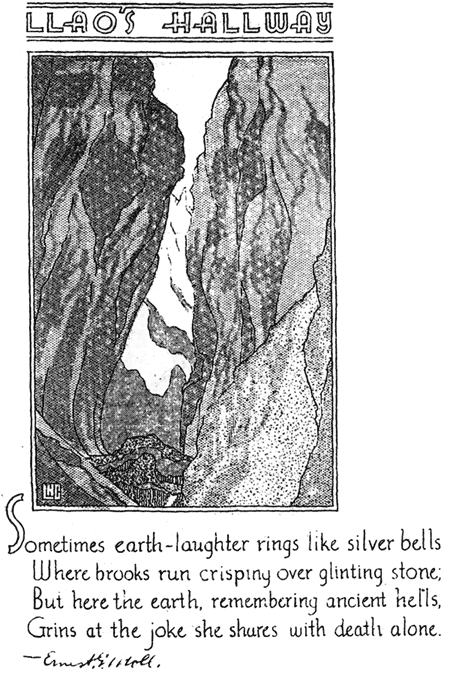
In Llao’s Hallway, we have a curious little canyon out in the same sort of materials found in the others mentioned, but much smaller and more weird. As one threads his way down this tortuous passageway, he may have the impression of passing down through a giant burrow of some subterranean monster, or in places he finds that he is in a tube with a narrow crack in top. The Hallway is only about a quarter of a mile long and in the summer is dry, being cut entirely in pumice, and mud flow debris. In places the walls overhang and the view of the sky is completely shut off. It has been well named and one can easily imagine the great Indian God of Evil who lived in the hot lake, (before Crater lake cooled off), strolling or hurrying down this maize-like passageway on some evil mission.
People who intend to explore this interesting feature of the Park, (which is located in Whitehorse, a tributary of Castle Creek), should be sure not to be caught in there during a thunder storm as it is almost impossible to get out of the long passage until one has reached the end. Also, one should be on the look out for falling stones from above. Fortunately, these are mainly light pumice and do not weigh very much, but even a big chunk of pumice on top of one’s head can cause a good headache.
Space does not permit any more detailed description of some of these interesting places. Furthermore, if the reader has access to Nature Notes files of earlier years, he will find an article on the pinnacles by the then Park Naturalist, D. S. Libbey, in Vol. IV No. 3, (September 1931), and one on Llao’s Hallway by W. G. Moody, Acting Park Naturalist, in Vol. VI, No. 2 (July 1933).
We should say a word about the Rogue River and its canyon stretches just by way of contrast to those in the Park since the traveler will be coming or going into the Park at some time by the Medford Road and he will glance down perchance into some of the yawning chasms cut by this fine river. In the upper reaches the Rogue has worked down into much the same character of deposits we find in the other canyons names, but when one gets lower down toward the Medford country he finds the river cutting into solid rock. This rock is a lava, but an older and denser lava than is to be seen at Crater Lake. It is a basalt. One big query arises here in passing — one which is often asked us on duty at the Rim — “Did this lava in the Rogue River canyon flow out of the side of Mt. Mazama when it collapsed?” If this were so, our problem of the destruction of Mt. Mazama would be solved. Unfortunately we must say no. This is an older basalt of Miocene age and is perhaps the equivalent of the Columbia Lava Plateau.
Just outside the Park to the southwest of Crater Lake, the country drops off rapidly into another canyon in this older basalt. The name of this is Red Blanket.
To some, canyons are merely gloomy and forbidding, others find them occasionally attractive, but the geologist finds them useful. The reason for this is that the geologist wants to know what is below the surface and ordinarily he cannot penetrate more than an infinitesimal part of the distance into the interior of the earth by drilling or digging, so when Nature has provided a natural, deep section into the outer crust of the earth, he can examine the materials exposed by this incision and thereby draw much clearer deductions than if he were looking at the surface merely and guessing at what lies beneath. Therefore a geologist, if he is a conscientious worker, will examine carefully every deep cut in the earth. This is the chief interest that such canyons as we have in the Park hold for us who are geologically inclined. Just as a surgeon has often times to make a deep incision into the body to locate the source of trouble or the anatomist makes sections of tissue, so do we rely upon those natural sections. However, in the body of the earth of course, we cannot for the lack of time, means, and power, hope to make artificial incisions into the earth or begin to do what the streams have done for us. We must rely upon every and all such natural sections.
From the foregoing, it is hoped the reader will obtain a respect for our canyons, their interesting features, their beauty, even though at times, awesome, and finally their great utility in deciphering the story of the past in this and all other regions where the pages of certain chapters of the Book of Rocks remain to be cut and deciphered.
Llao’s Hallway
Sometimes earth-laughter rings like silver bells
Where brooks run crisping over glinting stone;
But here the earth, remembering ancient hells,
Grins at the joke she shares with death alone.
Springs in the Park
By Carl E. Dutton, Ranger-Naturalist
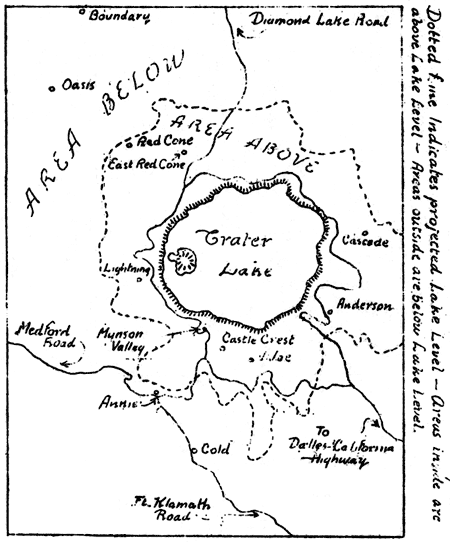
The springs which occur in Crater Lake National Park are individually different as to size and location but their general arrangement is shown by the accompanying sketch map. A consideration of the conditions represented will quickly reveal that four springs lie at elevations below the surface of the lake and they therefore probably represent underground outlets for the seepage which takes place from the lake.
The other springs, which lie at elevations above the surface of the lake, are principally located at the edge of catchment areas covered by pumice. These springs seem to be fed by the downward percolation of rain and melted snow through the sieve-like pumice cover until some non-porous layer diverts the water along the line of flow to the spring.
The above descriptions refer to those springs which are named as such on the topographic map of this area. There are, however, also a number of creeks whose headwaters might be considered springs since the water has a rather definite outlet and a well defined flow. The material in this article is limited so as not to include the very numerous occurrences of this type.
Boundary Springs — The voluminous headwaters of the Rogue River gush from the hillsides along the western portion of the northern boundary of the Park. The flow of water comes from the northward facing bouldery slope of a ravine trending westward. The head of the ravine slopes northwestward from the upland surface and then turns sharply toward the west. The most remote contribution to the headwaters comes from a spring situated at the designated turn in the ravine. The stream from this source is approximately 18 inches wide and 3 inches deep. The next spring basin is located about 70 feet west of the first one and consists of two defined outlets and much disseminated seepage. The channel of this flow is four feet wide but the stream is of an intricately braided pattern because of the numerous boulders which divert and subdivide the streamlets. The combined widths of the streamlets aggregate one third to one fourth of the channel width and their average depth is four to six inches.
The most important flow to the Rogue River comes from a spring situated about 100 feet west of the second one described. The flow from this main spring is sufficient to create a stream whose dimensions are about eight feet wide by ten inches deep and whose estimated velocity was two feet per second. The channel averages 15 feet in width but is so partially blocked by boulders and logs that the water tumbles in cascades over and between the numerous obstructions which are abundantly mantled with green mosses. When the area was visited in August, the yellow monkey flower(Mimulus guttatus) was blooming profusely and because it grew among the mosses, the color combination in the vegetation was that of a yellow and green polk-a-dot pattern.
A fourth spring basin occurs about 200 feet west of the main spring just described and is the nearest one to the loop of the motor-way which terminates at this location. The stream is four feet wide and five inches deep. It flows in a separate ravine which trends eastward to join the main valley which contains the waters fleeing from the other subterranean passages.
Anna Springs — This spring is one of the most accessible in the Park and although situated just northeast of the Checking Station, the pool has reflected the visages of few visitors. The water escapes in a natural amphitheater basin which has been landscaped by a semicircular retaining wall about 12 feet high. The slope above the basin is steep and is composed of fractured and slightly decayed rock. A pool about 20 feet long, eight feet wide, and three feet deep has been formed to serve as a reservoir but it also adds to the beauty of the spring. The water flow is mainly from beneath the north central portion of wall but some also is added from both sides of the central flow. Beyond the dam at the lower end of the pool, the flow is the beginning of Anna Creek — three feet wide and eight inches deep — which soon passes through a delightful valley and helps in the carving of Godfrey’s Glen. The flow from this spring is of sufficient volume and velocity that it operates water-rams which supply the tap-water for this locality.
Munson Valley Spring — These outlets of underground water are unnamed on the topographic map but since they are situated on the western slops of the designated valley, the given name will serve here. This basin furnishes the third largest flow known in the Park and is used as a supply for the Rim Village and Government Camp. The basin has the form of an amphitheater open to the south. The basin is about 100 feet wide and 60 feet deep. From its bouldery slopes, there arise five springs which occur mainly along the north and northeast base of the area. The water is tiled to a reservoir and then pumped to the storage tank on the Garfield Peak Trail. The road to the Rim passes along the open end of the basin but only the most observing person would notice the springs although the abundance of Lewis’ Monkey flower (Mimulus lewisii) and the fleabane (Erigeron salsuginosus) cause many exclamations.
Cascade Springs — This group of springs is located about 1-1/2 miles northeast of Skell Head. They are the least accessible ones visited and are unique in their arrangement. A ravine trending northwest for 100 feet, then turning due north for another 100 feet, is cut through bouldery slopes whose upper surface is covered with a pumice mantle. On the southwestern side of the ravine, there are 14 separate outlets of ground water and also many scattered areas of seepage. On the northeastern and southern sides, there are five distinct springs and also seepage. The number of springs and their occurrence on both sides of the ravine were of special interest. The stream resulting from these springs is Bear Creek which is three feet wide and four inches deep and has an estimated flow of one foot per second. The course of the stream is beautifully decorated with moss covered rocks and many blossoms of the yellow monkey flower. This area is of further interest because of an entrancing waterfall, about 20 feet high, in which the water breaks into many nebulous fluttering ribbons.
Springs within the Crater Rim — There are a few contributions of ground water to the lake by means of springs and seepage. The greatest zone of flow occurs from The Sentinel Point area where the seepage becomes concentrated into streamlets which cascade down the steep talus slopes to the Lake. Another considerable flow comes from rock slopes about 1/4 mile east from the foot of the Trail to the Lake.
Notes on other springs in the Park — Of the many other springs present in the Park, only a few are considered worthy of notice in this article.
Anderson Spring. Near top of Anderson Bluffs in eastern area of Park. Small flow from line of four springs along slope.
Castle Crest Spring. The largest flow in this group and irrigates the gorgeous floral display of the Wild Flower Garden.
Cold Spring. Along road to Fort Klamath, below Pole Bridge Creek. Small flow from marshy area.
East Red Cone Spring. Southeastern base of Red Cone. Two pools in pasture-like area; resulting stream again sinks into ground.
Lightning Spring. Southwest of The Watchman. Flow from bouldery slope with pumice covering upland.
Oasis Spring. Northern base of Oasis Butte in northwestern portion of Park. Flow sufficient to “boil” sand and plant remains on bottom. Bubbles rise through water when observer jumps on ground around springs.
Red Cone Spring. Northwestern base of Red Cone. Flow from base of bouldery slope with timbered upland.
Vidae Spring. Eastern slope of Vidae Ridge; unnamed on topographic map but is source of Vidae Creek; located below pumice flat.
Latest Flowering Plants in Crater Lake National Park
By Elmer I. Applegate, Ranger-Naturalist
In common with other regions of high altitude, the flowering time for plants in the Park is relatively short. The seasons vary greatly, depending largely upon the snowfall. While nearer normal, the present is at least a month later than last year.
The earliest flowers to appear are normally in the lower levels. Many of these have a comparatively longer flowering season and a greater altitudinal as well as geographical distribution, following up to higher levels with the advance of the season. Of these,Phlox Douglasii (Douglas’s Phlox) is a noteworthy example. In the Lava Beds Monument it was out during the month of May; a month later it was in flower in the yellow pine zone of the Park, and late in July it was in all its glory on the lower slopes of the Watchman and the pumice fields to the north and westward. Even as late as the middle of August this ubiquitous plant will follow the last of the lingering snow-drifts farther up the slope.
Of the earliest and more fleeting flowers to appear in the hemlock zone, might be mentioned the yellow Erythronium (E. grandiflorum pallidum) which adds much to the floral beauty of Sun Creek Valley, and the Western Windflower (Anemone occidentalis),so attractively decorating the first bare spots at the entrance of Castle Creek Garden. In their restricted habitats, they come immediately after the disappearance of the snow, and follow closely the retreating drifts, their season being regulated by the depth.
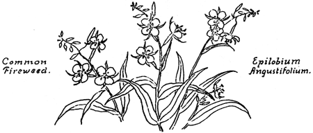
A number of the more conspicuous plants are not in flower until the season is considerably advanced, or even well into the second half. These, for the most part, continue to flower until early snowfall. As common elsewhere, members of the Aster family dominate. Of these, one of the most widely distributed and attractive perennials is Engelmann’s Aster, sometimes know as Colville’s Aster. The many tall leafy stems form large rounded or spreading clumps. By the latter part of August the purple flower-heads will add much to the color of the pumice flats and slopes, notably about Government Camp and the Rim area. Intermingled with it, or dominating some areas, will be bright golden-yellow spots and patches of Bloomer’s Rabbit Brush(Chrysothamnus bloomeri). In less abundance is the gray-leaved Rabbit Brush (C. nauseosus speciosus). On the slopes of Garfield Peak it can be seen along the trail. Just at this time one of the most attractive of the late bloomers is the Western Boneset(Eupatorium occidentale). This, with its many-stemmed pink or lavender-colored flower-heads, is rather abundant and especially noticeable on the lava flows of Wizard Island, and more common along the rocky lake shore at the Wine Glass. Everywhere on the pumice fields of the upper areas, is the Pyrola-leaved Eriogonum (E. pyrolifolium).By the first of August, the tall corn-like stalks of the green False Hellebore (Veratrum viride) with their panicles of greenish-white flowers will be much in evidence, and the pink-flowered common Fireweed (Epilobium angustifolium) will be at its best. The Silver Plant (Raillardella argentea) forms shining silvery mats on the higher summits. More rare and seldom seen by visitors to the Park, are the bog-loving Parnassia intermediawith its white buttercup looking flowers, and the beautiful little gentian (Gentiana simplex). with its single deep blue flower. These two plants are to be found at Boundary Spring and Copeland Creek. It is interesting to note that the common sagebrush(Artemisia tridentata) which contributes so much to the gray color of the plaints and deserts of the west, occurs on the dry talus slope of the crater wall at the Wine Glass. There it is associated with the yellow pine and other plants of the Transition life zone. It will not be in flower before the last of August, which is about the time it will be out in the Lava Beds area.
Food Habits of Crater Lake National Park
By J. S. Brode, Ranger-Naturalist
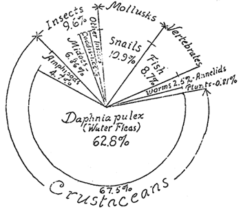
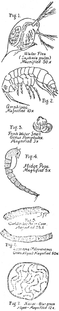 One way of determining the life forms of a lake is by noting the food of the fish. During the last three weeks of July and the first week of August, fifty fish stomachs received from fisherman from the lake were examined and their contents noted. All but four of these fish were Silverside trout averaging sixteen and a half inches in length; the four were small Rainbow trout. In examining the contents of the stomachs one is impressed by the fact that the diet of a particular individual is apt to be of one kind of food rather than from a wide range of kinds. For example, one fish will have concentrated on snails, one on midges, one on water fleas, and one on water-stranded land insects, or perhaps on worms. The largest individual form found was a seven-inch fish; the smallest individual used for food (exclusive of forms such as diatoms which are basically food of the fish food) is the water flea of Daphnia pulex (fig. 1). This minute crustacean was found in 74 percent of the fish examined and made up 62.8 percent of volume of food eaten by the fifty trout. These forms are rarely found at the surface of the lake, being most abundant at depths of 75 to 200 feet. The closely related Amphipod (fig. 2) locally known as fresh-water shrimp which is fairly abundant in the marginal waters of the lake is sixth in importance as fish food; it was found in 24 percent of the stomachs and made up 4.7 percent of the volume of food used by the fifty fish.
In point of total bulk, the snails come second in importance as food, as they make up 10.9 percent of the food eaten. The snail used most by the fish is Pompholex species? (fig. 3) the middle-sized form of the three Crater Lake snails. It was found in 22 percent of the stomachs examined.
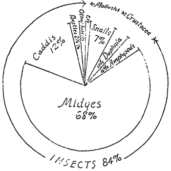
The various forms of insects make up the third largest amount of fish food, 9.6 percent, and were used by 54 percent of the fishes. However 6.86 of the 9.6 was made up of midges, larvae, pupae and adult stages (fig. 4). In some cases these made up the entire stomach contents. Land insects, when stranded by adverse wind currents sometimes make up the food; one fish had 11 beetles, 1 moth, 1 grasshopper or cricket, an ant, 1 bee, 2 bumble bees, 2 true bugs, as well as adult and pupa stages of midges, 3 snails and 1600 Daphnia. Of the water insects other than midges the Caddis fly, especially in the larva (penniwinkle stage) (fig. 5) is quite a favorite of off-shore feeding fish. They made up 1.66 percent of the volume of fish food though found in but 14 percent of the fish. Mayflies also form part of the fishes’ diet (0.65 percent)
The annelids formed only 2.53 percent of the food mass. Three small leeches (38 inch) were noted, and one stomach was largely filled with 65 worms, smaller than the earthworm but closely allied to it. These worms have been found in muddy pools along the lake margin and also in bottom tows to a depth of 90 feet.
The two fishes found in the diet made up 8.7 percent of the total mass though found in only 4 percent of the fish stomachs. The distinguishable plant material was relatively small, being only 0.8 percent of the diet and consisted of leathery Nostoc, a blue-green algae (fig. 6) and wads of filamentous green algae, probably Zygnema(fig. 7).
| Number of specimens |
Percent of total volume |
Fish eating number specimens |
|
| CRUSTACEANS | |||
| Amphipods | 1081 | 4.7 | 12 |
| Daphnia | 57657 | 62.8 | 37 |
|
58738 |
67.5 |
||
| INSECTS | |||
| Midges | 3018 | 6.86 | 22 |
| Caddis | 34 | 1.66 | 7 |
| May fly | 149 | .65 | 4 |
| Beetles | 19 | .20 | 3 |
| Bee, Ant | 4 | .13 | 3 |
| Moth | 2 | .08 | 2 |
| True bugs | 2 | .02 | 1 |
|
3228 |
9.60 |
||
| ANNELIDS | |||
| Leeches | 3 | .026 | 1 |
| Worms | 65 | 2.49 | 1 |
| MOLLUSCS | |||
| Snails | 399 | 10.9 | 11 |
| FISH | |||
| 2 | 8.7 | 2 | |
| PLANTS | |||
| Blue-green algae (Nostoc) | 12 balls | .26 | 2 |
| Green filamentous algae (Zygnema) | 6 cc | .55 | 2 |
Food of Crater Lake Fish (46 Silverside Trout and 4 Rainbow Trout). Reported by J. S. Brode, Aug. 1935.
Food of Crater Lake Fish (for the most part Rainbow Trout) as reported by C. Anderson Hubbard the season of 1933.
Other pages in this section