

Volume 10 No. 1 – June 1, 1937All material courtesy of the National Park Service. These publications can also be found at http://npshistory.com/Nature Notes is produced by the National Park Service. © 1937 |
| Nature Notes from Crater Lake National Park are issued during the summer months. These pamphlets contain articles describing the natural features of the Park, Oregon Caves National Monument and Lava Beds National Monument, the two monuments being administered by the staff of Crater Lake National Park. Copies of Nature Notes may be obtained from the Park Superintendent, Crater Lake, Oregon. The reprinting of the articles appearing in Nature Notes is encouraged. Please give credit to the pamphlet and author. | ||
| David H. Canfield Superintendent |
John E. Doerr, Jr., Editor Park Naturalist |
|
|
|
||
Cover Design – Nancy Elliott Doerr
Preface
By John E. Doerr, Jr., Editor
Crater Lake National Park
The park includes an area of 250 square miles on the crest of the Cascade Range in southern Oregon. The area was established as a national park in 1902, preserving the unsurpassed scenic beauty of Crater Lake, a deep lake, the clear fresh water of which reflects and refracts unusual hues of blue. Color is only one of the elements of the inspiring beauty of Crater Lake. Its setting is unique. The lake, having an area of 20 square miles, is cupped within the crater of an extinct volcano. Cliffs 500 to 2000 feet high completely surround the lake. The crater walls are partially mantled with hemlock, fir, and pine trees. On the gentle outer slopes of the mountain which one ascends in approaching Crater Lake there are deep canyons, magnificent forests and open meadows supporting a colorful display of mountain wild flowers. Hiking and fishing are popular outdoor sports during the summer months. Skiing is popular in the winter, and the park being accessible throughout the winter months by the west entrance road from Medford and the south entrance road from Klamath Falls.
Oregon Caves National Monument
This national monument, an area of 480 acres, is located in the Siskiyou Mountains in southwestern Oregon. The caves, named “The Marble Halls of Oregon” by Joaquin Miller, are truly marble halls. Underground water penetrating to great depth along fractures in the marble formation has dissolved out an extensive system of chambers. Water dripping from the ceiling and walls has decorated the halls and passageways with fantastic stalactites and stalagmites which stimulate one’s imagination as well as one’s appreciation of the beauties of nature in caverns never touched by sunlight. In the magnificent forest around the cave entrance there are trails along which one gets inspiring views of forest-covered mountains and valleys. Along the trails one can observe many species of trees, mammals, and birds.
Lava Beds National Monument
Located in northeastern California, the monument includes an area of 45,000 acres. As the name suggests, volcanic formations, some of quite recent origin, are of greatest importance. There are hundreds of lava tubes which were once the passageways for streams of molten lava. Volcanic cones rise above the general level of the adjacent country. There are excellent examples of “aa” and “pahoehoe” lava flows. Within the monument there are interesting historical features including battlefields of the Modoc War of 1872-73. There are important ethnological and archaeological features. Petroglyphs on cliffs and pictographs in caves are evidence that the region was inhabited by primitive people long before the coming of the white man.
Snowfall, Precipitation and Lake Levels
By W. T. Frost, Ranger and John E. Doerr, Jr., Park Naturalist
A combination of many features makes Crater Lake an outstanding scenic attraction as well as a most interesting and unique lake. John Wesley Hillman, the discoverer of Crater Lake, recorded in a description of the discovery that he and his companions were impressed with a number of features, among them, that the lake apparently had no inlet and no outlet. That characteristic feature of Crater Lake continues to impress thousands of visitors viewing the lake today from numerous observation points on the rim of the crater in which it is cupped. The realization that there is neither a visible inlet nor outlet, combined with the fact that the water of the lake is fresh, and that its location in the top of a mountain, the structure of which is such as to eliminate the possibility of the lake being fed by appreciable amounts of water from springs, stimulates many questions. Many of the questions concerning the source of water, loss of water, its purity, and changes in lake levels, seasonal as well as changes over a period of years, can be answered. The answers to many of the questions about the unique features of Crater Lake are based on observations which have been made for a number of years.
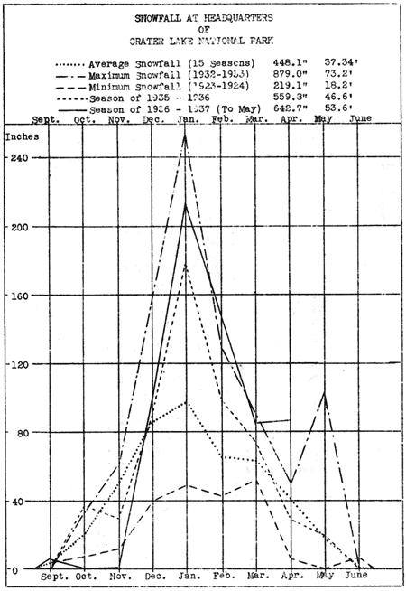
For this article on Snowfall, Precipitation and Lake Levels of Crater Lake, Ranger W. T. Frost has prepared compiled data for an interesting graph and several charts. Those will be of great value in helping visitors in the park and readers of Nature Notes to gain an appreciation of some of the unique features of Crater Lake.
The observation of snowfall and precipitation at Crater Lake, or, expressed in another manner, observations of inflow of Crater Lake, since the lake receives its water entirely from snow and rain falling within the crater rim, as well as observations of changes in lake levels are not only interesting but of practical value in estimating the supply of spring water in the park, and the inflow of water into streams and lakes beyond the boundaries of the park.
It is interesting to note, from data compiled by the U. S. Reclamation Service, that during the period 1905-1915, when the level of Crater Lake varied less than two feet, the inflow of Upper Klamath Lake – in the valley south of Crater Lake – remained fairly constant. During the period 1915-1934 there has been a constant but gradual lowering of the level of Crater Lake, and a fairly constant decrease in the inflow of Upper Klamath Lake. Since 1934 the level of Crater Lake has varied within 0.89 of a foot and the inflow of Upper Klamath Lake has increased slightly. It is evident that accurate observation of snowfall, precipitation, and lake levels at Crater Lake increase our knowledge of the lake, and certainly such observations are of value to organizations outside the park that are concerned with supply and distribution of water, an appreciable amount of which is no doubt the seepage from Crater Lake.
| SNOWFALL AT CRATER LAKE NATIONAL PARK
|
|||||||
| Month | 1936-37 | 1935-36 | 1934-35 | 1933-34 | 1932-33 | 1931-32 | Average 5 seasons |
|
|
|||||||
| July | .00 | .00 | .00 | .00 | .00 | .00 | .00 |
| August | .00 | .00 | .00 | .00 | .00 | .00 | .00 |
| September | 6.00 | .00 | 5.80 | 4.00 | .00 | 3.00 | 2.56 |
| October | .00 | 36.80 | 28.90 | 26.00 | 33.00 | 31.00 | 31.14 |
| November | .50 | 29.50 | 128.00 | 20.00 | 61.00 | 114.00 | 70.50 |
| December | 98.30 | 90.50 | 113.50 | 142.70 | 156.00 | 151.50 | 130.80 |
| January | 213.35 | 179.00 | 117.00 | 96.30 | 256.00 | 132.50 | 166.16 |
| February | 151.00 | 100.00 | 56.00 | 38.40 | 130.00 | 69.00 | 78.68 |
| March | 86.50 | 75.00 | 129.00 | 10.90 | 91.00 | 111.00 | 83.38 |
| April | 87.00 | 29.00 | 62.00 | 31.00 | 49.00 | 91.00 | 52.40 |
| May | 18.00 | 20.00 | .00 | 10.00 | 103.00 | 38.00 | 34.20 |
| June | .00
|
.00
|
.00
|
2.00
|
.00
|
.00
|
.40
|
| Total (in.) | 66.65 | 559.80 | 640.00 | 381.70 | 879.00 | 791.00 | 650.22 |
| Total (ft.) | 55.05 | 46.6 | 53.3 | 31.8 | 73.2 | 65.9 | 54.185 |
| AVERAGE SNOWFALL FOR 15 YEARS | |
| July | .00 |
| August | .00 |
| September | 3.80 |
| October | 20.30 |
| November | 49.50 |
| December | 86.10 |
| January | 96.00 |
| February | 66.00 |
| March | 63.60 |
| April | 41.20 |
| May | 18.30 |
| June | 1.30
|
| Total (in.) | 448.10 |
| Total (ft.) | 37.34 |
(click on image for an enlargement in a new window)
| COMPARISON OF CHANGES IN LAKE LEVELS WITH CHANGES IN SNOWFALL AND PRECIPITATION IN CRATER LAKE NATIONAL PARK
|
||||
| Year | Low Lake Level of the year |
Number of Feet below High Point of 1910 |
Total Seasonal Snowfall (Feet) |
Total seasonal Precipitation (Inches) |
| 1908 | 6175.94 | 1.23 | ||
| 1909 | 6176.33 | .84 | ||
| 1910 | 6177.17 | Highest level | ||
| 1911 | 6175.62 | 1.55 | ||
| 1912 | 6175.92 | 1.25 | No records | |
| 1913 | 6175.56 | .61 | ||
|
|
||||
| 1918 | 6173.50 | 3.67 | ||
| 1919 | 6172.75 | 4.42 | ||
| 1920 | 6171.75 | 5.42 | 20.3 | |
| 1921 | 6173.75 | 3.42 | 34.6 | |
| 1922 | 6173.54 | 3.63 | 23.2 | |
| 1923 | 6171.83 | 5.34 | 24.0 | |
| 1924 | 6170.17 | 7.00 | 18.2 | |
| 1925 | 6170.08 | 7.09 | 34.1 | |
| 1926 | 6168.33 | 8.84 | ||
| 1927 | 6169.75 | 7.42 | 52.3 | |
| 1928 | 6168.58 | 8.59 | 7.5 | |
| 1929 | 6166.91 | 10.26 | ||
| 1930 | 6165.61 | 11.56 | 30.3 | |
| 1931 | 6163.26 | 13.91 | 22.6 | |
| 1932 | 6163.71 | 13.46 | 65.9 | 74.91 |
| 1933 | 6164.46 | 12.71 | 73.2 | 75.46 |
| 1934 | 6163.41 | 13.76 | 31.8 | 54.22 |
| (Lowest record) | ||||
| 1935 | 6164.30 | 12.87 | 53.3 | 72.23 |
| 1936 | 6163.81 | 13.36 | 46.6 | 55.30 |
(Wed Edition Note: This table contains revisions that were identified in Nature Notes Vol. X, No. 3)
| COMPARISON TABLE OF SEASONAL VARIATION IN LAKE LEVEL
|
|||
| Year | Period | Number of feet variation during the year (in feet) |
Seasonal Snowfall (in feet) |
|
|
|||
| 1936 | June 10 – Sept 5 | 1.25 | 46.6 |
| 1935 | June 27 – Sept 2 | 1.06 | 53.3 |
| 1934 | June 15 – Oct 1 | 1.95 | 31.8 |
| 1928 | July 1 – Oct 1 | 2.33 | 27.5 |
| 1926 | May 22 – Sept 15 | 1.66 | – |
| 1925 | July 1 – Sept 22 | 1.66 | 34.1 |
| 1924 | June 2 – Sept 2 | 1.38 | 18.2 |
| 1923 | July 1 – Sept 24 | 1.10 | 24.0 |
| Average seasonal variation | 1.55 | 33.64 | |
Lake level is falling at an average rate of .51 foot per year.
(Estimated from figures over a 26 year period).
| PRECIPITATION AT CRATER LAKE NATIONAL PARK
|
|||||||
| Month | 1936-37 | 1935-36 | 1934-35 | 1933-34 | 1932-33 | 1931-32 | Average 5 seasons |
|
|
|||||||
| July | .63 | 1.48 | .11 | .00 | .37 | .06 | .404 |
| August | .00 | .62 | .88 | .42 | .39 | .40 | .542 |
| September | 1.50 | .35 | .73 | 4.59 | .00 | 2.74 | 1.682 |
| October | .00 | 5.19 | 9.91 | 3.90 | 3.85 | 6.39 | 5.848 |
| November | .07 | 2.45 | 15.59 | 1.63 | 8.04 | 11.03 | 7.748 |
| December | 10.50 | 6.27 | 14.11 | 13.94 | 12.07 | 14.14 | 12.106 |
| January | 9.59 | 18.41 | 10.16 | 3.47 | 10.12 | 4.45 | 6.528 |
| February | 9.66 | 9.89 | 4.71 | 3.47 | 10.12 | 4.45 | 6.528 |
| March | 6.53 | 3.83 | 8.28 | 6.28 | 7.06 | 11.97 | 7.494 |
| April | 2.03 | 7.07 | 4.04 | 3.58 | 6.45 | 4.634 | |
| May | 2.22 | .26 | 2.65 | 9.03 | 3.75 | 3.582 | |
| June |
|
2.51
|
.42
|
1.89
|
4.70
|
.12
|
1.928
|
| Total Inches | 55.30 | 72.23 | 54.22 | 75.46 | 74.91 | 66.424 | |
Outline of Events in the History of the Modoc War
By Don C. Fisher, Assistant Chief Ranger and John E. Doerr, Jr., Park Naturalist

Introduction
Beginning with this number of Nature Notes from Crater Lake National Park, and continuing through Volume X which will be issued during the summer months of 1937,Nature Notes will present an Outline of the Events in the History of the Modoc War. In preparing this outline the authors have described briefly the important events in the development of south central Oregon and northeastern California during the period 1846-1873. That period was one of constant struggle between the white settlers and the Modoc Indians. There were acts of treachery, murders, massacres and numerous councils, culminating in the Modoc War of 1872 – 1873. The most important battles of the war took place in the area of what is now the Lava Beds National Monument in northeastern California. The places where important events of the war took place are among the most interesting features of the Monument. – Editor
(click on image for an enlargement in a new window)
Part I
1846 – 1870
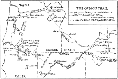
| 1846 | South Emigrant Trail (Applegate Trail) established. |
| Lindsay Applegate, accompanied by fourteen other settlers in the Willamette and Rogue valleys in western Oregon, established the South Emigrant Trail between a point on the Oregon Trail near Fort Hall, Idaho and the Willamette Valley. The purpose of this new route, shown on the map on the opposite page, were to encourage settlers to western Oregon, to eliminate the hazards encountered on the Columbia Route, to provide an alternate route in the event of trouble with England, Hudson’s Bay Company controlled the Columbia Route, and to provide a route which would be open except for a short winter season each year.From what is now Dalles, Oregon, the Applegate party went south up the Willamette Valley, through the Umpqua and Rogue River valleys to a point near what is now Ashland, Oregon. From there the party proceeded eastward, crossing the Cascade Range near Green Springs Mountain, to Spencer Creek near the present town of Keno, Oregon. From there a route was selected around the south end of Lower Klamath Lake, then northward along the high ground between Lower Klamath Lake and Tule Lake to a ford on Lost River (“Stone Bridge”). Passing north of Tule Lake and Clear Lake the party continued eastward to Goose Lake, then southeast across the Black Rock Desert to what is now Winnemucca on the Humboldt River in Nevada. Following up river about 200 miles, then continuing northeast, the party reached Hot Springs Valley on the Oregon Trail, about 50 miles southeast of Fort Hall, Idaho. | |
The first emigrants to reach western Oregon by way of the South Emigrant Trail arrived in the fall of 1846, having been conducted west by the Applegate party on their return from Hot Springs Valley.
Lindsay Applegate and his party were the first white men to enter what is now the Lava Beds National Monument. On their exploring trip eastward they attempted to pass around the south end of Tule Lake but the rough lava along the shore forced them to seek a route around the north end of the lake. Visitors going to the Lava Beds National Monument by way of the road south of Merrill, Oregon, cross Lost River at the “Stone Bridge” over which hundreds of emigrants passed on their way to western Oregon. A monument near the bridge records the names of the men in the Applegate party.
Many of the events of the Modoc War took place along the South Emigrant Trail.
1847-51 Modoc Indians molested emigrants on the South Emigrant Trail.The Modoc Indians, numbering about 600 warriors under the leadership of Old Chief Schonchin, inhabited the region around Lower Klamath Lake, Tule Lake, and Lost River in northern California and southern Oregon. The Modoc Indians were part of the Klamath tribe, a division of the tribe having taken place many years before the first white men came into the region.
California became a state in 1850.
1852 First massacre of emigrants by Modoc Indians at Bloody Point.In September the Modocs destroyed an emigrant train at Bloody Point on the east shore of Tule Lake. Of the 65 persons in the train only three escaped immediate death; two young girls, taken prisoners and killed several years later by jealous Modoc women, and one man who made his way to Yreka, California. Hearing the news of the massacre, Yreka settlers organized a party, under the leadership of Jim Crosby, to go to the scene of the massacre to bury the dead and avenge their death. Crosby’s party had one skirmish with a band of Modocs.
1853-55 Modoc Indians continued to harass and massacre emigrants on the South Emigrant Trail.
1856 Ben Wright Massacre.The depredations and massacres of emigrants by the Modoc Indians aroused settlers at Yreka, California to send out a party under Ben Wright’s leadership. Accounts differ as to what actually took place when Wright’s party finally met the Indians on Lost River. Both the white men and the Indians anticipated treachery. Each group planned to exterminate the other. To prevent the gathering of the entire tribe which would result in his party being greatly outnumbered, Wright attacked, killing approximately 80 Indians. This loss broke the power of the tribe but kindled the Modoc hatred for the white people, a hatred which flamed up many times in the years following.
1857-62 Modoc Indians continued to harass and massacre emigrants on the South Emigrant Trail.History does not record the actual number of emigrants killed nor the number of wagon trains destroyed. It has been estimated that at least 300 emigrants and settlers were killed by the Modoc Indians during the years 1846 to 1873.
Oregon became a state in 1859.1863
Fort Klamath established. This fort was built by Captain William Kelly, Co. “C” 1st Oregon Cavalry. It was built on the trail between the Upper Klamath Valley and Jacksonville, Oregon. Fort Klamath remained an army post until 1889 at which time it was abandoned. The paved highway between the present town of Fort Klamath and Annie Spring, in Crater Lake National Park, and west to Medford follows closely the route of the old military road built across the Cascade Range by soldiers stationed at Forth Klamath. Some of the early events in the history of Crater Lake occurred in connection with the building of the military road.1864Treaty between the United States and the Klamath, Modoc, and Snake (Yahooskin band) Indians.
The Klamath Reservation established. Under the terms of this treaty the Modoc Indians, with old Chief Schonchin as their leader, gave up their lands in the Lost River, Tule Lake and Lower Klamath Lake regions, and moved to the reservation in the Upper Klamath Valley. Approximately 160 Modoc Indians under the leadership of Keintpoos (Captain Jack), refused to move to the reservation even though they had agreed to do so in signing the treaty. It was Captain Jack’s band of Modocs that caused the trouble which precipitated the Modoc War. The majority of the Modoc tribe under Old Chief Schonchin remained on the reservation, taking no part in the Modoc War.1865Captain McGregor, Commanding Officer at Fort Klamath, made and unsuccessful attempt to get Captain Jack and his band to the reservation.
1866 Lindsay Applegate, Agent on the reservation, failed in an attempt to get Captain Jack’s band to the reservation.1867Captain Jack’s band of Modocs continue to harass settlers in the Lost River Valley.
J. W. Perit Huntington, Superintendent of Indian Affairs for Oregon, made an unsuccessful attempt to get Jack’s band to the reservation.
First building erected on the site of Linkville (Klamath Falls, Oregon) by George Nurse and Edgar Overton.
1869 Captain Jack and his band of Modocs moved to the reservation. This move was accomplished following a council between Captain Jack; A. B. Meacham, Superintendent of Indian Affairs for Oregon; O. C. Knapp, Agent on the reservation; Ivan D. Applegate, Sub Agent at Yainax; and W. C. McKay. Talk at the council accomplished nothing. When troops suddenly appeared at the meeting place the Indian warriors fled, leaving their women and children behind. Meacham put the women and children in wagons and started for the reservation. “Queen” Mary, Captain Jack’s sister, was permitted to go to Captain Jack to persuade him to move to the reservation. Her efforts were successful. Arriving on the reservation, Jack and his band prepared to make permanent homes at Modoc Point.
1870 Captain Jack and his band left the reservation and returned to their former homes on Lost River. Shortly after Captain Jack and his band started building permanent homes at Modoc Point, the Klamath Indians began to molest them, making it necessary for the band to move to another part of the reservation. Several attempts were made to find a location. The Klamaths continued to harass the band until finally Captain Jack and his followers left the reservation and returned to Lost River. During the summer months that Captain Jack had been on the reservation a number of settlers had taken up land in the Lost River region.
Other pages in this section