
Weather and Climate Inventory, Klamath Network, National Park Service, 2007
4.0. Station Inventory
4.1. Climate and Weather Networks
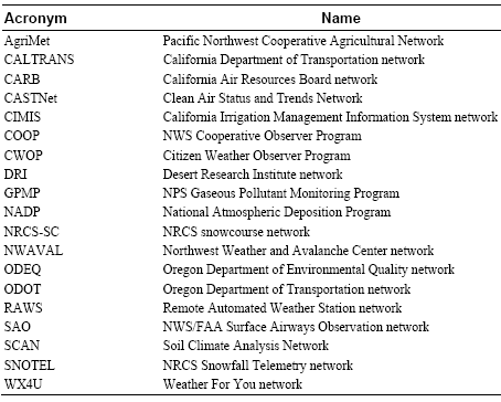
Most stations in the KLMN region are associated with at least one of 19 major weather/climate networks (Table 4.1). Brief descriptions of each weather/climate network are provided below (see Appendix G for greater detail).
Table 4.1. Weather/climate networks represented within the KLMN.
4.1.1. Pacific Northwest Cooperative Agricultural Network (AgriMet)
AgriMet is a network of automated weather stations operated by the U.S. Bureau of Reclamation. The stations in AgriMet are located primarily in irrigated agricultural areas throughout the Pacific Northwest.
4.1.2. California Department of Transportation (CALTRANS) Network
These weather stations are operated by the CALTRANS in support of management activities for California’s transportation network. Measured meteorological elements usually include temperature, precipitation, wind, and relative humidity.
4.1.3. California Air Resources Board (CARB) Network
Meteorological measurements are taken at CARB sites in support of their overall mission of promoting and protecting public health, welfare and ecological resources in California through the reduction of air pollutants, while accounting for economical effects of such measures. Measured elements include temperature, relative humidity, precipitation, and wind speed and direction.
4.1.4. Clean Air Status and Trends Network (CASTNet)
CASTNet is primarily an air-quality monitoring network managed by the EPA. Standard hourly weather and climate elements are measured and include temperature, wind, humidity, solar radiation, soil temperature, and sometimes moisture. These elements are intended to support interpretation of air-quality parameters that also are measured at CASTNet sites. Data records at CASTNet sites are generally one–two decades in length.
4.1.5. California Irrigation Management Information System (CIMIS) Network
The California Irrigation Management Information System (CIMIS), operated through the California Department of Water Resources, is a network of over 120 automated weather stations in the state of California. CIMIS stations are used to assist irrigators in managing their water resources efficiently. Measured meteorological elements at CIMIS stations generally include temperature, precipitation, wind, and solar radiation. Some stations measure additional parameters such as soil temperature and moisture.
4.1.6. NWS Cooperative Observer Program (COOP)
The COOP network has been a foundation of the U.S. climate program for decades and continues to play an important role. Manual measurements are made by volunteers and consist of daily maximum and minimum temperatures, observation-time temperature, daily precipitation, daily snowfall, and snow depth. When blended with NWS measurements, the data set is known as SOD, or “Summary of the Day.” The quality of data from COOP sites ranges from excellent to modest.
4.1.7. Citizen Weather Observer Program (CWOP)
The CWOP network consists primarily of automated weather stations operated by private citizens who have either an Internet connection and/or a wireless Ham radio setup. Data from CWOP stations are specifically intended for use in research, education, and homeland security activities. Although standard meteorological elements such as temperature, precipitation, and wind are measured at all CWOP stations, station characteristics do vary, including sensor types and site exposure.
4.1.8. Desert Research Institute (DRI) Network
The Desert Research Institute (DRI) operates this network of automated weather stations, located primarily in California and Western Nevada. Many of these stations are located in remote mountain and desert locations and provide data that are often used in support of various environmental studies. Meteorology elements are measured every 10 minutes and include temperature, wind, humidity, barometric pressure, precipitation, and solar radiation.
4.1.9. Gaseous Pollutant Monitoring Program (GPMP)
The GPMP network measures hourly meteorological data in support of pollutant monitoring activities. Measured elements include temperature, precipitation, humidity, wind, solar radiation, and surface wetness. These data are generally of high quality, with records extending up to two decades in length.
4.1.10. National Atmospheric Deposition Program (NADP)
The purpose of the NADP network is to monitor primarily wet deposition at selected sites around the U.S. and its territories. The network is a collaborative effort among several agencies including USDA and the U.S. Geological Survey (USGS). Precipitation is the primary climate parameter measured at NADP sites.
4.1.11. USDA/NRCS Snowcourse Network (NRCS-SC)
The USDA/NRCS maintains a network of snow-monitoring stations in addition to SNOTEL (described below). These sites are known as snowcourses. These are all manual sites, measuring only snow depth and snow water content one–two times per month during the months of January to June. Data records for these snowcourses often extend back to the 1920s or 1930s, and the data are generally of high quality. Many of these sites have been replaced by SNOTEL sites, but several hundred snowcourses are still in operation.
4.1.12. Northwest Weather and Avalanche Center Network (NWAVAL)
The Northwest Weather and Avalanche Center (NWAC) operates a network of weather stations in the mountainous areas of the Pacific Northwest, primarily in Washington. These stations are operated in support of NWAC’s primary mission of monitoring avalanche conditions in the mountains of Washington and northern Oregon. Hourly weather and climate elements that are measured include temperature, humidity, wind, and precipitation. Daily measurements are made of snowfall and snowdepth.
4.1.13. Oregon Department of Environmental Quality (ODEQ) Network
The primary mission of ODEQ is to protect and enhance Oregon’s air and water quality. Weather and climate elements are measured by ODEQ stations in support of this primary mission. Measured meteorological elements include temperature, precipitation, wind, and relative humidity.
4.1.14. Oregon Department of Transportation (ODOT) Network
These weather stations are operated by ODOT in support of management activities for Oregon’s transportation network. Measured meteorological elements include temperature, precipitation, wind, and relative humidity.
4.1.15. Remote Automated Weather Station (RAWS) Network
The RAWS network is administered through many land management agencies, particularly the BLM and the Forest Service. Hourly meteorology elements are measured and include temperature, wind, humidity, solar radiation, barometric pressure, fuel temperature, and precipitation (when temperatures are above freezing). The fire community is the primary client for RAWS data. These sites are remote and data typically are transmitted via GOES (Geostationary Operational Environmental Satellite). Some sites operate all winter. Most data records for RAWS sites began during or after the mid-1980s.
4.1.16. NWS Surface Airways Observation Network (SAO)
These stations are located usually at major airports and military bases. Almost all SAO sites are automated. The hourly data measured at these sites include temperature, precipitation, humidity, wind, pressure, sky cover, ceiling, visibility, and current weather. Most data records begin during or after the 1940s, and these data are generally of high quality.
4.1.17. USDA/NRCS Soil Climate Analysis Network (SCAN)
The SCAN network is administered by NRCS and is intended to be a comprehensive nationwide soil moisture and climate information system to be used in supporting natural resource assessments and other conservation activities. These stations are usually located in the agricultural areas of the U.S. All SCAN sites are automated. The parameters measured at these sites include air temperature, precipitation, humidity, wind, pressure, solar radiation, snow depth, and snow water content.
4.1.18. USDA/NRCS Snowfall Telemetry (SNOTEL) Network
The USDA/NRCS maintains a network of automated snow-monitoring stations known as SNOTEL. The network was implemented originally to measure daily precipitation and snow water content. Many modern SNOTEL sites now record hourly data, with some sites now recording temperature and snow depth. Most data records began during or after the mid-1970s.
4.1.19. Weather For You Network (WX4U)
The WX4U network is a nationwide collection of weather stations run by local observers. Data quality varies with site. Standard meteorological elements are measured and usually include temperature, precipitation, wind, and humidity.
4.1.20. California Data Exchange Center (CDEC)
Some stations are identified in this report as CDEC stations. This is a data repository for a variety of California stations from agencies which include but are not limited to the California Department of Water Resources, BLM, and various power and other utility companies. Despite the variety of agencies involved, these stations are all still referred to as CDEC stations. Measured meteorological elements vary widely depending on agency. Data from CDEC stations are usually hourly.
4.1.21. Weather Bureau Army Navy (WBAN)
Some stations are identified in this report as WBAN stations. This is a station identification system rather than a true weather/climate network. Stations identified with WBAN are largely historical stations that reported meteorological observations on the WBAN weather observation forms that were common during the early and middle parts of the twentieth century. The use of WBAN numbers to identify stations was one of the first attempts in the U.S. to use a coordinated station numbering scheme between several weather station networks, such as the COOP and SAO networks.
4.1.22. Other Networks
In addition to the major networks mentioned above, there are various networks that are operated for specific purposes by specific organizations or governmental agencies or scientific research projects. These networks could be present within KLMN but have not been identified in this report. Some of the commonly used networks include the following:
- NOAA upper-air stations
- Federal and state departments of transportation
- U.S. Department of Energy Surface Radiation Budget Network (Surfrad)
- Park-specific-monitoring networks and stations
- Other research or project networks having many possible owners
Other pages in this section