Figure 4.1. Station locations for the KLMN park units.
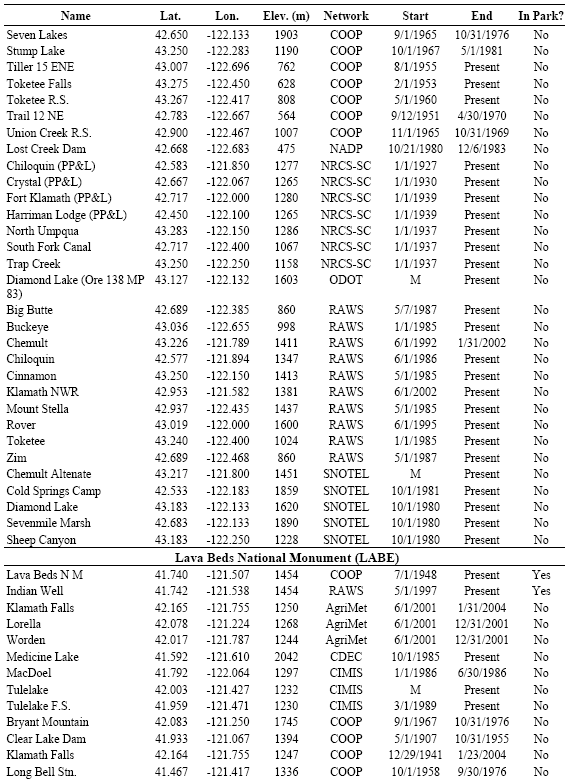
Several weather/climate networks have been identified that currently provide near-real-time data for the region surrounding LABE. A CDEC station (Medicine Lake) and two CIMIS stations (“Tulelake” and “Tulelake F.S.”) have been identified within 40 km of LABE (Table 4.3). A SAO station is located at Klamath Falls, 37 km northwest of LABE (Figure 4.1). This SAO station has operated since 1941. A SCAN station (Lynhart Ranch) was identified 19 km northeast of LABE. Eight RAWS stations (seven active) were identified within 40 km of LABE. One of the active stations (Adin – Portable) has a questionable data record. Of the remaining RAWS stations, the longest record comes from “Juanita Lake,” which is 33 km west of LABE and has operated since 1986. This station, however, recently had a large data gap for the first half of 2006. Three of the RAWS stations have very complete data records. These include “Lower Klamath” (2002-present), 21 km northwest of LABE; “Round Mountain” (1991-present), 29 km south of LABE; and “Van Bremmer” (1993-present), 17 km southwest of LABE.
Eight weather/climate stations were identified within the boundaries of LAVO (Table 4.3). Five of these stations are still active. The majority of the stations within LAVO are located at or near the visitor center at the northwest corner of the park unit (Figure 4.1), including a CARB station (Lassen Volcanic NP – Manzanita), a CASTNet station (Manzanita Lake F.S.), one of the two COOP stations in the park unit (Manzanita Lake), and a NADP station (Lassen Volcanic NP – Manzanita). The CARB and CASTNet sites are the main source for automated data within LAVO. The longest climate record is from the COOP station “Manzanita Lake,” which has been active since 1949. The COOP station “Mount Harkness,” located in southeastern LAVO, also provides a longer data record, having been active since 1953.
Out of the eight COOP stations identified within 40 km of the boundaries of LAVO, three are active (Table 4.3). The longest record we identified was from the COOP station “Chester,” which is 13 km southeast of LAVO and has been active since October 1909. The record at this station is very complete. Another reliable long-term record was identified at the COOP station “Mineral,” which is located 9 km southwest of LAVO and has been active since November 1909. The COOP station “Chester R.S.” is 16 km southeast of LAVO and has been active since 1955.


