Weather and Climate Inventory, Klamath Network, National Park Service, 2007
4.0. Station Inventory
4.2. Station Locations
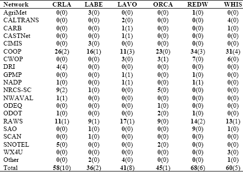
The major weather/climate networks in the KLMN (discussed in Section 4.1) have at most several stations at or inside each park unit (Table 4.2). Most of these are COOP stations.
Table 4.2. Number of stations within or nearby KLMN park units. Numbers are listed by park unit and by weather/climate network. Figures in parentheses indicate the numbers of stations within park boundaries.
Network CRLA LABE LAVO ORCA REDW WHIS
Lists of stations have been compiled for the KLMN. As was mentioned previously, a station does not have to be within park boundaries to provide useful data and information regarding a given park unit. Some might be physically within the administrative or political boundaries, whereas others might be just outside, or even some distance away, but would be nearby in behavior and representativeness. What constitutes “useful” and “representative” are also significant questions, whose answers can vary according to application, type of element, period of record, procedural or methodological observation conventions, and the like.
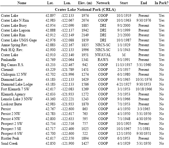
Ten weather/climate stations were identified within the boundaries of CRLA (Table 4.3; Figure 4.1). Only one of these is inactive; this was a COOP station that operated on Crater Lake’s north rim from 1963 until 1976. The COOP station “Crater Lake” is located at Rim Village on the lake’s southern rim and provides the longest climate record in the park. This station has operated since 1919. With the exception of numerous gaps from 1943 through September 1946, this station has a very complete data record. Desert Research Institute (DRI) operates a few stations throughout the park unit; most of these stations started operating in 1999 or 2000. “Crater Lake Buoy” is located on Crater Lake itself. “Crater Lake USGS Gage” (1987-present) is situated at Cleetwood Cove along the north shore of the lake. The other two DRI stations are located in south CRLA. “Crater Lake Rim” is located at Rim Village, while “Crater Lake Lagoon” is near park headquarters. Two NRCS-SC sites are within CRLA; “Park H.Q. Rev.” is just southeast of Rim Village, while “Annie Spring Rev.” is 5 km south of Rim Village. The NWAVAL station “Crater Lake” is near Rim Village. The only RAWS station we identified within CRLA (Panhandle) is in the extreme southern portion of the park.
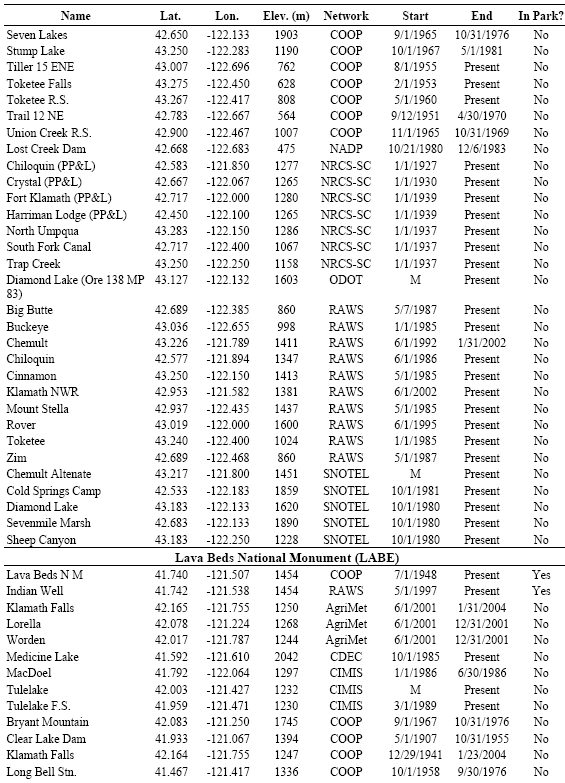
Table 4.3. Weather/climate stations for the KLMN park units. Stations inside park units and within 40 km of the park unit boundary are included. Missing entries are indicated by “M”.
Of the 24 COOP stations we identified within 40 km of CRLA (Table 4.3), 10 are active. The COOP station “Prospect 2 SW” is located 22 km southwest of CRLA and provides the longest climate record in the area (1905-present).The data record at “Prospect 2 SW” is very complete. Another long-term record is available at the COOP station “Chemult,” 24 km northeast of CRLA. This station’s data record, which goes back to 1937, was very complete until 1980 but has had scattered data gaps since then. Several other active COOP stations within 40 km of CRLA have data records that go back to the 1950s.
Despite only identifying one RAWS station within CRLA (Panhandle), there are numerous RAWS stations within 40 km of the park unit (Table 4.3). The RAWS stations “Big Butte” and “Rover” have data records that are unreliable. Other than these two stations, the remaining stations have fairly complete data records. The longest data records come from the RAWS stations “Buckeye” (29 km west of CRLA) and “Toketee” (22 km northwest of CRLA), both starting in January 1985. The only RAWS stations for which we didn’t note significant data gaps are “Chiloquin” (1986-present), located 26 km southeast of CRLA, and “Klamath NWR” (2002-present), located 26 km southeast of CRLA.
We identified five SNOTEL sites (all active) within 40 km of CRLA (Table 4.3). Along with RAWS sites, SNOTEL sites are the primary sources of automated weather data for the region surrounding CRLA. The closest SNOTEL site to CRLA is “Sevenmile Marsh,” located 11 km south of the park unit. “Cold Springs Camp” is another SNOTEL station located south of CRLA (28 km from park unit). The remaining SNOTEL stations we identified were located north and northeast of the park unit (Figure 4.1).
We identified two stations (both active) within LABE (Table 4.3; Figure 4.1). The COOP station “Lava Beds N M” is located in south-central LABE and provides a data record going back to 1948.This data record is fairly complete but had numerous data gaps during the 1970s and 1980s. The RAWS station “Indian Well” is also located in south-central LABE and has been providing near-real-time weather data since 1997. There were numerous data gaps at this RAWS site from 1997 to 1999, but the data record has been very complete since 1999.
Figure 4.1. Station locations for the KLMN park units.
Several weather/climate networks have been identified that currently provide near-real-time data for the region surrounding LABE. A CDEC station (Medicine Lake) and two CIMIS stations (“Tulelake” and “Tulelake F.S.”) have been identified within 40 km of LABE (Table 4.3). A SAO station is located at Klamath Falls, 37 km northwest of LABE (Figure 4.1). This SAO station has operated since 1941. A SCAN station (Lynhart Ranch) was identified 19 km northeast of LABE. Eight RAWS stations (seven active) were identified within 40 km of LABE. One of the active stations (Adin – Portable) has a questionable data record. Of the remaining RAWS stations, the longest record comes from “Juanita Lake,” which is 33 km west of LABE and has operated since 1986. This station, however, recently had a large data gap for the first half of 2006. Three of the RAWS stations have very complete data records. These include “Lower Klamath” (2002-present), 21 km northwest of LABE; “Round Mountain” (1991-present), 29 km south of LABE; and “Van Bremmer” (1993-present), 17 km southwest of LABE.
Eight weather/climate stations were identified within the boundaries of LAVO (Table 4.3). Five of these stations are still active. The majority of the stations within LAVO are located at or near the visitor center at the northwest corner of the park unit (Figure 4.1), including a CARB station (Lassen Volcanic NP – Manzanita), a CASTNet station (Manzanita Lake F.S.), one of the two COOP stations in the park unit (Manzanita Lake), and a NADP station (Lassen Volcanic NP – Manzanita). The CARB and CASTNet sites are the main source for automated data within LAVO. The longest climate record is from the COOP station “Manzanita Lake,” which has been active since 1949. The COOP station “Mount Harkness,” located in southeastern LAVO, also provides a longer data record, having been active since 1953.
Out of the eight COOP stations identified within 40 km of the boundaries of LAVO, three are active (Table 4.3). The longest record we identified was from the COOP station “Chester,” which is 13 km southeast of LAVO and has been active since October 1909. The record at this station is very complete. Another reliable long-term record was identified at the COOP station “Mineral,” which is located 9 km southwest of LAVO and has been active since November 1909. The COOP station “Chester R.S.” is 16 km southeast of LAVO and has been active since 1955.
RAWS stations are the primary source of near-real-time data within 40 km of LAVO. Sixteen RAWS stations were identified; 13 of these are active (Table 4.3). The only RAWS stations with unreliable data records are “LN2-Portable” and “LN3-Portable,” both located 16 km east of LAVO (Figure 4.1). Most of the 16 RAWS stations have occasional, small data gaps. The most complete data records come from the stations “Carpenter Ridge” (2000-present), 40 km south of LAVO, and “Whitmore” (1990-present), 29 km northwest of LAVO.
One weather station was identified within the boundaries of ORCA (Table 4.3; Figure 4.1). This is a CWOP station (CW2072 Oregon Caves) that provides near-real-time data.
Out of the 23 COOP stations identified within 40 km of the boundaries of ORCA, 13 are active (Table 4.3). The closest COOP station to ORCA is “Bolan Peak,” which is 8 km southwest of ORCA and has been active since 1953. The longest record we identified was from the COOP station “Williams 1 NW,” which is 17 km northeast of ORCA and has been active since 1892. This is a precipitation-only site whose data record is very complete. Another reliable long-term record was identified at the COOP station “Grants Pass,” which is 37 km north of ORCA and has been active since 1893. The COOP station “Happy Camp R.S.” (1914-present) is 32 km south of ORCA. The data record at this site is fairly complete but there are scattered, small data gaps and there are generally no weekend observations. Three other active COOP stations have data records going back to the 1930s and 1940s. “Elk Valley” is 28 km southwest of ORCA and has been active since 1938. This station’s data record has not been reliable since the 1970s. “Buncom 1 NNE” is 35 km northeast of ORCA and has been active since 1948. This station’s data record is mostly complete except for data gaps in August-October of 1984 and in January-October of 1985. “Star R.S.” is 28 km northeast of ORCA and has been active since 1948. Several other active COOP stations we identified have data records beginning in the 1950s and 1960s.
Five active NRCS-SC sites were identified within 40 km of ORCA (Table 4.3). Most of these are located south and east of the park unit (Figure 4.1). The closest sites to ORCA are “Althouse #2” (8 km south) and “Grayback Peak” (8 km east).
RAWS and SNOTEL stations are the primary source of near-real-time data within 40 km of ORCA (Table 4.3; Figure 4.1). Nine RAWS stations were identified; six of these are active (Table 4.3). The most complete data records come from the stations “Illinois Valley Airport” (1985-present), 21 km west of ORCA, and “Provolt Seed Orchard” (1985-present), 25 km northeast of ORCA. Two SNOTEL stations are located within 40 km of ORCA. “Bigelow Camp” is 4 km southeast of ORCA and “King Mountain” is 17 km southeast of ORCA.
Six weather/climate stations were identified within REDW (Table 4.3). Five of these stations are still active. The longest climate record is at the COOP station “Orick Prairie,” which is in the south-central portion of REDW (Figure 4.1) and has been active since 1937. This climate record is fairly complete, with occasional, small data gaps. The COOP station “Schoolhouse Peak,” located in the southeastern part of REDW, also provides a longer data record, having been active since 1953. The NADP station “Yurok Tribe-Requa” is located just north of the mouth of the Klamath River. Two RAWS stations are currently operating within REDW. “Schoolhouse” is in the southeastern part of REDW and has a very complete data record going back to 2001. “Westside” is in the south-central REDW and has been active since 2004. “Westside” has a data gap from January through March in 2005.
Out of the 31 COOP stations identified within 40 km of the boundaries of REDW, 10 are active (Table 4.3). The COOP station “Eureka,” 34 km south of REDW, has the longest record among these active COOP stations, having been active since 1886. The data record at “Eureka” is very complete. The COOP station “Crescent City,” 6 km west of the north end of REDW, has been active since 1893. The record at this station is largely complete but there were no weekend observations during the 1960s and 1970s. A very reliable long-term record was identified at the COOP station “Orleans,” which is located 33 km east of REDW and has been active since 1903. The COOP station “Elk Valley,” discussed previously, is 36 km northeast of the northern end of REDW. “Gasquet R.S.” is a precipitation-only COOP station that is 10 km east of the northern end of REDW and has a very complete data record (1948-present). The COOP station “Klamath” is just outside of central REDW and has a very reliable data record (1948-present).
Stations with the RAWS and SAO networks are the primary source of near-real-time data within 40 km of REDW units (Table 4.3; Figure 4.1). Twelve RAWS stations (11 active) and nine SAO stations (eight active) were identified. Three of the RAWS stations we identified (Kneeland, Ship Mtn., Ship Mtn. 1) have unreliable data records. “Kneeland” is located 40 km south of REDW. “Ship Mtn.” and “Ship Mtn. 1” are both located east of the north end of REDW. The RAWS station “Gasquet” (1993-present), 9 km east of the northern part of REDW, was unreliable until 1999. The RAWS station “Camp Six” (2003-present), 14 km east of the northern part of REDW, had a large data gap from February 2004 until June 2004. Six of the RAWS stations have very complete data records. Four of these (Big Mill, Hoopa, Maple Creek, and Yurok) are located within 40 km of southern REDW. The other two (“Oak Knoll” and “Red Mound”) are located within 40 km of the northern part of REDW. The remaining RAWS stations we identified have occasional, small data gaps.
The longest record among the SAO stations we identified for REDW comes from “Eureka,” 34 km south of REDW. This dataset goes back to 1886. Another long data record comes from the SAO station “Brookings” (1912-present), 24 km north of REDW. Two other active SAO stations (“Arcata” and “Crescent City”) have data records going back to the 1940s. The SAO station “Crescent City”, 8 km west of the northern part of REDW, is the closest SAO station to REDW.
Five weather/climate stations were identified within WHIS (Table 4.3; Figure 4.1). Three of these stations are active, including two COOP stations and one RAWS stations. The COOP station “Whiskeytown Reservoir” has a very complete data record which starts in 1960. The other active COOP station, “Redding 12 WNW,” is located in the northwestern part of WHIS and has been active since 2003. The RAWS station “Oak Bottom” has a very complete data record which starts in 2001.
Out of the 27 COOP stations identified within 40 km of the boundaries of WHIS, eight are active (Table 4.3). The COOP station “Weaverville,” 22 km west of the Trinity Unit, has the longest record among these active COOP stations, having been active since 1894. The data record at “Eureka” is fairly complete, with occasional, small data gaps. The COOP station “Shasta Dam” is just south of the Shasta Lake Unit of WHIS and has been active since 1943. The record at this station is very complete. Another data record starting in 1943 comes from the COOP station “Harrison Gulch R.S.,” which is located 33 km southwest of the Whiskeytown Unit. This station has no weekend observations and is generally quite unreliable. The COOP station “Redding” is 18 km from WHIS and has a reliable data record.
With the exception of the SAO station “Redding” and a few stations with other networks (CALTRANS, CARB, CWOP and WX4U), RAWS stations are the primary source of automated weather data within 40 km of WHIS units. Seven active RAWS stations were identified (Table 4.3). The longest RAWS record is from the station “Patty Mocus,” 35 km southwest of the Whiskeytown Unit of WHIS. This station has been active since1990; however, its data record has only been reliable since March 1999. The other active sites have fairly reliable data records, with occasional small data gaps.
Other pages in this section


