The Geology and Petrography of Crater Lake National Park, 1902
PART I.
MOUNT MAZAMA.
ORIGINAL CONDITION OF MOUNT MAZAMA.
Thus far the existence of an original Mount Mazama has been assumed. The evidence on which this assumption is based may be briefly stated as follows: The inner slope of the rim presents sections of the broken lava flows, which radiate from the lake and were evidently effused from a source higher in each case than the respective flow in the rim. If the flows of the rim were restored to their original size by extending them inward from the rim, they would converge to a common source and make a volcano which would occupy the place of the caldera and make a prominent peak, Mount Mazama.
The peak must have had a crater similar in character to that of Wizard Island, for it was the source of much fragmental material spread in all directions on the mountain slope.
The former existence of Mount Mazama is indicated also by the radial dikes which cut the rim. They evidently originated from pressure in a column of molten material in the chimney of a volcanic peak rising some distance at least above the rim.
The most convincing evidence of the existence of Mount Mazama on the site of Crater Lake is to be found in the glaciation and drainage of the rim. The radiating glaciers, which in their descent scored the crest of the rim, could have come only from a central peak. The records of the ice and water drainage from this peak in the topography of the rim are unmistakable.
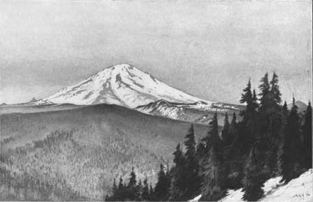
There can be no reasonable doubt as to the former existence of Mount Mazama, but its shape and size are more difficult to determine. Mount Mazama is composed largely of lavas similar to those of Mount Shasta, and from the slopes of that famous peak we may draw an inference as to those of Mount Mazama. Mount Shasta, unlike Mount Mazama, does not stand on an elevated platform. It rises with a majestic sweep of 11,000 feet from gentle slopes about its base, gradually growing steeper upward to the bold peak. At the height of 8,000 feet it has about the same diameter as Mount Mazama at an equal elevation in the rim of Crater Lake. Above this Mount Shasta rises over 6,300 feet. The prominence of Mount Mazama as a drainage center is quite equal to that of Mount Shasta, but its slopes on the rim of Crater Lake, ranging from 10° to 15°, are scarcely as great as those of Mount Shasta at a corresponding elevation. On the other hand, the canyons of Sun and Sand creeks on Mount Mazama are more profound and have been much more deeply glaciated than any of those on Mount Shasta. It therefore appears reasonable to suppose that Mount Mazama had an altitude at least as great, and possibly greater, than Mount Shasta (14,380 feet).
From a large amount of data at hand concerning the base of Mount Mazama, an attempt has been made to restore its summit, and Pl. XII, A, illustrates the result. It is pictured as it would now appear, with a small but distinct glacier representing the Anna Creek glacier, which once overflowed the divide westward into the Rogue River drainage.
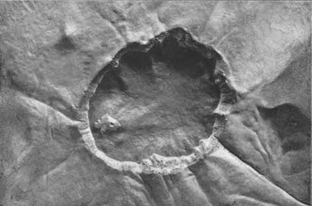
From the same general position, but at a somewhat greater elevation, a view of the rim as it appears to-day has been prepared by the same artist, and is shown in Pl. XII, B.
Plate XII.—A. MOUNT MAZAMA RESTORED.
Plate XII.—B. RIM OF CRATER LAKE.


