Volcano and Earthquake Hazards in the Crater Lake Region, Oregon
Landslides May Cause Large Waves on Crater Lake
How Large Must an Earthquake be to Trigger Landslides?
A possible trigger for a landslide that might generate dangerous waves would be ground shaking during an earthquake on the WKLFZ, especially the Annie Spring and Red Cone Spring faults. In order to cause a wave, the avalanche or slide must travel rapidly into or beneath the lake. There are many types of “landslides” that may be triggered by earthquake shaking. Those considered possible at Crater Lake include disrupted falls, slides, and avalanches of rock, soil (broadly defined as a loose, unconsolidated, or poorly cemented aggregate of particles), or snow and coherent slumps and block slides (as defined by Keefer, 1984). Subaqueous slides are likely to consist of the same kinds of rock or soil as in subaerial slides, rather than sand or finer-grained sediments, so that we will not differentiate between the two environments for purposes of this report. Moreover, because we are concerned with falls and slides that may displace sufficient lake water to cause damaging waves, we only consider large volume landslides that move very to extremely rapidly. This eliminates coherent slides and snow avalanches from our analysis.
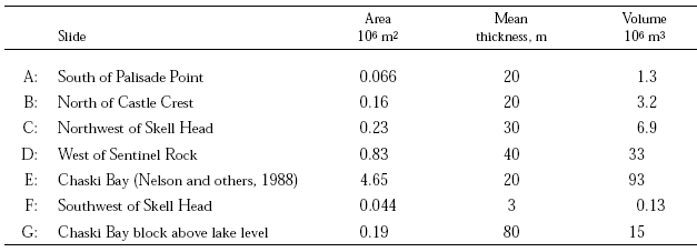
Table 6.—Approximate minimum areas, thicknesses, and volumes of probable landslides at Crater Lake [m2, square meters; m, meters; m3, cubic meters]
5 Modified Mercalli Intensity IV: “Hanging objects swing. Vibration like passing of heavy trucks; or sensation of a jolt like a heavy ball striking the walls. Standing motor cars rock. Windows, dishes, doors rattle. Glasses clink. Crockery clashes. In the upper range of IV wooden walls and frame creak.” Modified Mercalli Intensity VI: “Felt by all. Many frightened and run outdoors. Persons walk unsteadily. Windows, dishes, glassware broken. Knickknacks, books, etc., off shelves. Pictures off walls. Furniture moved or overturned. Weak plaster and masonry D [poor quality] cracked. Small bells ring (church, school). Trees, bushes shaken (visibly, or heard to rustle).”
Keefer (1984) provides guidelines for evaluating the potential of earthquakes of a given magnitude and epicentral distance to induce the various kinds of landslides. In terms of Modified Mercalli Intensity (MMI), a measure of local shaking, disrupted slides and falls would be expected to be common at MMI ³ VI. However, the minimum intensity for such occurrences would be IV5. The smallest local earthquake in Keefer’s study that triggered rock falls and slides had ML = 4.0. Thus, the maximum volcanic earthquake, with epicenter at Crater Lake, would be expected to cause rock falls and slides both above and beneath the lake. Plots of maximum distance from earthquake epicenter to landslides for earthquakes of different magnitudes (Keefer, 1984, fig. 2) provide a guide to the likely effects at Crater Lake of earthquakes with epicenters at a distance of 60 km, such as the September 1993, events. In this case, disrupted falls, slides, or avalanches could occur for M ³ 5.7. The effect of a large earthquake on the Cascadia subduction zone can be evaluated from plots of magnitude versus maximum distance from the fault-rupture zone (Keefer, 1984, fig. 3), which we consider to be more relevant than the epicenter of a large, distant event. Here, we assume a minimum distance of 100 km from the gently inclined fault-rupture zone and determine that disrupted falls or slides may occur for an earthquake of M ³ 6.5. Clearly, the maximum event (table 5) is more than adequate to induce disrupted falls and slides at Crater Lake. A great earthquake on the Cascadia subduction zone would result in a longer duration of shaking, perhaps one to several minutes (Wong and Silva, 1996), than would a smaller local event and this undoubtedly would increase the probability of slides.
Another way to look at the potential for earthquake-induced rock falls and slides is in relation to the critical ground acceleration (Ac = 0.05g ; Wilson and Keefer, 1985) necessary to cause motion of incoherent materials. The peak ground acceleration for sites on “soil” (any unconsolidated material; “rock” sites experience smaller accelerations) is given as a function of earthquake magnitude and distance from source in a relation developed specifically for extensional tectonic regimes, such as the Crater Lake area, by Spudich and others (1997). The distance is that to the nearest point on the surface projection of the area that slips in the earthquake. A peak horizontal acceleration of 0.05 g (+65%/-40%) would be expected to occur for a M = 5 earthquake at a distance of 23 km, M = 6 at 42 km, and M = 7 at 73 km. Earthquakes rupturing an area beneath Crater Lake, such as on the Annie Spring or Red Cone Spring faults projected downdip, could produce peak horizontal accelerations of 0.20 g for M = 5, 0.34 g for M = 6, and 0.57 g for M = 7 (all g values +65%/-40%). Recognizing the significant uncertainties inherent in empirical relations such as the one used to calculate acceleration, these results are consistent with volcanic, local tectonic, or distant Cascadia subduction zone earthquakes all having the potential to trigger failure of the fractured and poorly consolidated rock of the caldera walls and talus slopes.
In a different type of analysis, Geomatrix Consultants (1995, plate 3a) indicates a peak horizontal acceleration of ~0.14 g for sites on rock near Crater Lake and a return period of 500 years (mean annual frequency of exceedance of 0.002). This value takes earthquakes from all sources into consideration and includes estimates of the probability of earthquake occurrence. Increased return period (decreased mean annual frequency of exceedance) results in larger accelerations. Although not strictly comparable to our analysis, the Geomatrix study also indicates that peak horizontal accelerations at Crater Lake can significantly exceed Ac.

