The Geology of Crater Lake National Park, Oregon With a reconnaissance of the Cascade Range southward to Mount Shasta by Howell Williams
The Northern Arc of Vents
Dacites of Redcloud and Cloudcap
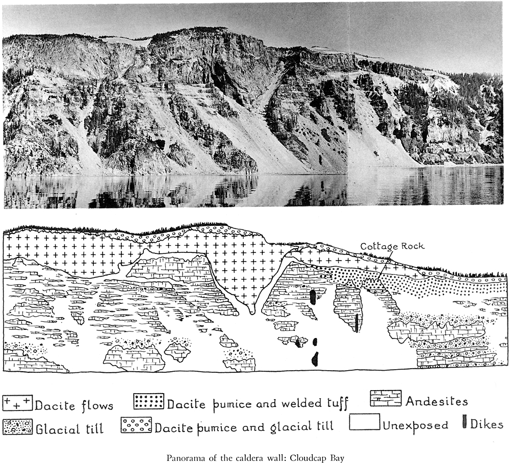
The topmost lavas on the caldera wall overlooking Cloudcap Bay are glassy dacites not unlike those of the Llao, Grouse Hill, and Cleetwood flows. They were likewise erupted after the andesitic phase of Mazama’s activity had come to an end. Two main flows may be distinguished: an older one to the south, which seems to have had its source beneath Cloudcap, and a much thicker flow farther north, the Redcloud flow, which escaped from a vent on the caldera wall. The relations between them are indicated on the panorama, plate 23.
Plate 23. Panorama of the caldera wall: Cloudcap Bay
The V-shaped cross section of the Redcloud lava is hardly less impressive than the great cliff of Llao on the opposite wall of the caldera. In its central part, the lava forms a precipice 600 feet in height. Some who view this massive flow from a distance are inclined to suppose that it poured down a deep, V-shaped river gorge, filling it to the brim and then spreading over the banks. A moment’s reflection should, however, dispel this idea. How could a V-shaped canyon of such proportions form on the side of Mount Mazama when U-shaped glacial canyons were being carved at the same time and at the same elevation a short distance away? Surely a river could not cut such a smooth-sided gorge across bedded lavas and ashes, and least of all so close to the summit of the mountain and in the short interval between successive advances of ice.
All doubt is removed by closer inspection. Then it becomes apparent that the lava occupies a funnel-shaped explosion vent and that the feeding pipe lies at the base of the great triangular cliff. Had the lava issued from a source higher up the slope of the volcano and flowed eastward down an old river gorge, the banding would dip eastward in conformity with the valley floor. In reality, the flow planes are disposed concentrically, like a series of hollow, inverted cones one within the other. Redcloud Cliff itself is not quite vertical, but inclines steeply toward the lake, and at its base there is a projecting, right-angled buttress, 20 yards long and 75 yards across, reminiscent of the larger buttress jutting from the base of Llao Rock. Within this buttress the flow planes are beautifully displayed, standing vertically and striking parallel to the margins. The conclusion cannot be avoided that this marks the actual conduit of the Redcloud dacite.
Along the borders of the great V, the lava is finely banded and locally crowded with spherulites. Partly encasing it are coarse tuff breccias consisting of angular blocks of dark, glassy dacite, up to 8 feet across, lying in an ashy matrix of the same, intermingled with white dacite pumice and occasional fragments of andesite. In places these peripheral breccias are well bedded, dipping under the lava and lakeward. Before the main flow was erupted, magma must have risen in the conduit, solidified there, and then been blown out together with pieces from the adjacent andesites. The presence of pumice among the ejecta offers a possible explanation for the explosions, suggesting that after the first surge of magma had congealed in the conduit, gases accumulated below until the pressure became adequate to blast a passage to the surface. In this way a large funnel-shaped crater was produced. Perhaps a broad and deep glacial depression already existed in the vicinity; otherwise, it is difficult to account for the paucity of old andesitic debris among the ejecta. Once the conduit had been cleared, viscous dacite rose into the crater and piled above it in the form of a low dome. Unable to move westward against the slope of Mount Mazama, the lava then began to flow sluggishly to the northeast. Despite its unusual thickness, it came to an abrupt end about a mile from the source.


