Formation of Crater Lake
Crater Lake occupies a basin in Mount Mazama, one of the volcanoes that make up the Cascades Mountain Range along the west coast of the United States. The major volcanoes of the Cascades include the following (listed from south to north):
- California: Lassen Peak and Mount Shasta.
- Oregon: Mount Mazama, Three Sisters, Mount Jefferson, and Mount Hood.
- Washington: Mount Saint Helens, Mount Adams, Mount Rainier, Glacier Peak, and Mount Baker.
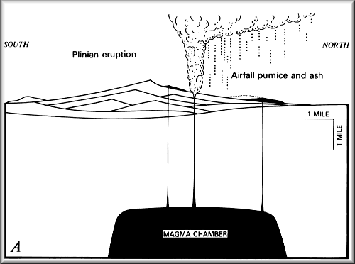
This generalized diagram of the formation of Crater Lake is animated from the 1959 edition of the 1:62,500 scale topographic map entitled “Crater Lake National Park and Vicinity, Oreg.”
Crater Lake is a beauty born from violent eruptions of spitting fires and rocks. The phrase “GREW, BLEW, FELL, and FILL” describes the process that created Crater Lake. Mount Mazama grew, erupted, then collapsed to form the caldera, and finally precipitation filled the caldera. Although Crater Lake has been dormant for about 5,000 to 6,000 years, there could be another eruption someday in the future and Mount Mazama might grow back. The long history of volcanism at Mount Mazama strongly suggests that this volcanic center will be active in the future.
GREW
Mount Mazama was a large composite volcano that was built during the past 400,000 years by hundreds of smaller eruptions of lava flows. Each layer is a different lava flow or, in some instances, pyroclastic deposit. These eruptions occurred from less than one year to thousands of years apart. Mount Mazama rose to an approximate height of 3,700 m (12,000 ft) above sea level. The caldera wall displays the geologic layering of lava flows through time.
BLEW
About 7,700 years ago, Mount Mazama erupted catastrophically, blowing out about 50 km3 (12 mi3) of magma as pyroclastic materials (mostly rhyodacite pumice and fine ash) in at most a few days. The volcanic ash covered parts of the northwestern states, spreading as far as central Canada. Rare particles of Mazama ash have even been found in ancient ice from Greenland. The airfall pumice and ash covered a total surface area of more than 2,600,000 km2 (1,000,000 mi2) at least 1 mm (fraction of an inch) thick. A volume of 42-54 km3 (10-13 mi3) of the mountaintop had disappeared.
Where had all this mass gone? Did Mount Mazama blow its top off?
FELL
Mount Mazama did not blow its top off; it collapsed in on itself. As this enormous volume of magma (54-63 km3, or 13-15 mi3) was rapidly removed from the chamber (about 5 km, or 3 mi below Earth’s surface) to feed the climactic eruption, it created a huge void underneath the mountain. Leaving no support for this massive dome, the roof of the magma chamber collapsed, forming the bowl-shape depression known as a caldera.
FILL
About 5,000 to 6,000 years ago, the accumulation of rain and snow filled the caldera. It took perhaps 250 years for the caldera to fill to its present-day lake level, which is maintained by a balance between precipitation and evaporation plus seepage.
Other pages in this section
*** previous title *** --- *** next title ***


