The entire day was spent trying to reformat the various navigation files from Sunday’s data so that one of them could be read by our processing software. Finally, near midnight, a fix was devised and tested. The fix required reading the navigation file recorded by Hydromap.
 |
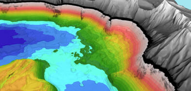
| Figure 19b. Chaski slide as seen with no water in Crater Lake. View is looking south. Chaski slide |
The mapping continued throughout the day and all but a small deep-water area and some shallow-water areas were completed. Chaski slide was entirely mapped and the below-water segment appears to be a debris avalanche, similar to the one discovered in Lake Tahoe during the 1998 mapping (Gardner et al., 2000). The area of the crater’s rim directly above the slide has also failed and may be related to the below-lake failure (Fig. 19).
Tuesday, August 1 (JD 214)
The mapping commenced by circumnavigating the lake twice to fill in data gaps and finally to beam-steer the transducer to ensonify as close to the shore as possible. Sunday’s data were processed, then Monday’s, and by 1000 hr the data processing was caught up with the data collection.
Wednesday, August 2 (JD 215)
The day was spent filling in small gaps to insure 100% coverage. We collected the data tape at noon so that the processing could be finished in the evening in time for packing the equipment van for an early-morning departure. The final few hours of data collected in the afternoon were quickly processed and the final maps (Figs. 12 and 13) were produced by 1800 hr.
The processing computers were shut down and the equipment van was packed by 2100 hr.
***previous*** — ***next***

