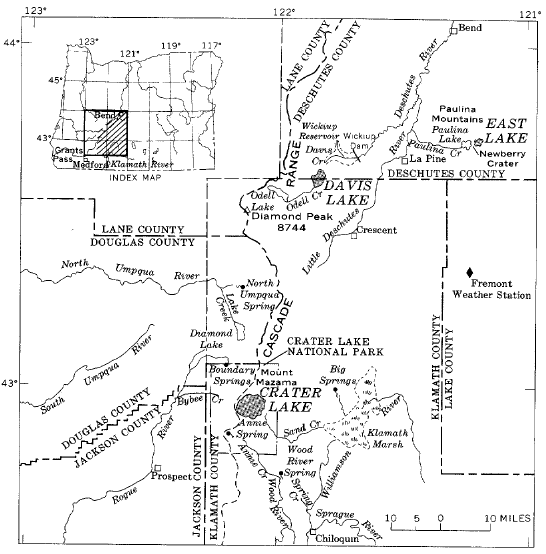
The physiographic setting of East Lake is similar to that of Crater Lake, except that East Lake occupies only 8.4 percent of Newberry caldera, whereas Crater Lake, including islands, occupies almost 80 percent of the total area of its caldera.
The geology of the region was described by Russell (1905, p. 97-110) and by Williams (1953, p. 41-52). The latter (p. 44) paints a vivid word picture of Newberry Volcano, as follows:
Its summit, Paulina Peak, rises almost 4,000 feet above the encircling plateau. The volcano is of the shield type, and has the shape of an inverted saucer, deeply dented on top and ornamented on the sides with many small knobs. Across the base, it measures 20 miles; on its flanks are more than 150 cinder cones; and on its summit there is a caldron, 4 to 5 miles wide, hemmed in on all but one side by precipitous walls up to 1,500 feet in height. Within this huge depression lie Paulina and East lakes.
The caldera is geologically recent. Williams concludes that it was formed perhaps 20,000 to 25,000 years ago by the collapse of the cone after radial drainage had caused a recession of the molten lava within the volcano and thus removed the support for its higher slopes. Some time later, new eruptions occurred within the caldera and on the outer slopes of the volcano. Explosive activity continued at intervals almost to the present time. Indian sandals, lying below Mount Newberry pumice deposits in caves near Fort Rock, 25 miles to the southeast, were found to be 9,000 years old by carbon-14 dating, and fragments of charcoal found in the topmost pumice layer between East and Paulina Lakes were found to be only 2,050 years old (Williams, 1953, p. 51). Some of the lava flows on the outer slopes of Newberry Mountain are probably not more than a thousand years old (Williams, 1935, p. 280).
East Lake, like Crater Lake, is therefore geologically young. After the caldera was formed 20,000 to 25,000 years ago, snow and ice doubtless accumulated in it to depths of several hundred feet, and outflowing ice may have slightly scoured the outlet to Deschutes River (Russell, 1905, p. 97-104). Ash and lapilli from late phases of volcanic activity were mingled with the accumulation of ice, and as the ice melted, these fine materials formed deposits that partly sealed the bed of the lake. By the time the recent eruptions within the crater had ceased, about 2,000 years ago, the two lakes had been separated, and probably each one was then near its present level.
Paulina Lake is drained by Paulina Creek westward into Deschutes River basin. There are no records of the annual outflow. Several small springs enter the lake near the water level, and at least one is thermal. There are no surface inflow streams. Most of the water supply is derived from snowmelt that infiltrates the permeable volcanic soil cover.
East Lake has no visible outlet and no perennial surface inflow. Small mineralized thermal springs occur near and below the lake surface along the southeastern shore, and others may exist at greater depths.
 |
| FIGURE 1.-Location of lakes discussed. |
***previous*** — ***next***

