Castle Crest Wildflower Garden Trail – Crater Lake National Park
Time: 30 – 45 minutes
Difficulty: Easy
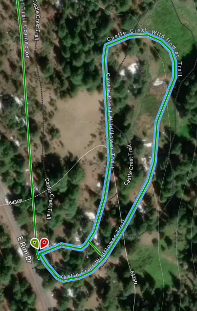
Length: .4 mi (.64 km) loop from East Rim Drive; 1 mile loop from park Headquarters
Elevation: 6434* – 6434* ft (1961* – 1961* m)
Highlight: Small brook, lush vegetation, spectacular blooms of wildflowers in summer months
REI Trails Project partners with Crater Lake Institute to produce their trails app. Click the map below, get the app – then come back, we offer more.
Trailhead coordinates:
Latitude: N +42° 53.45 or 42.89085
Longitude: W -122° 07.92 or -122.13213
Altitude: 6434* ft (1961* m) *from garden parking area, not headquarters
Trail Description
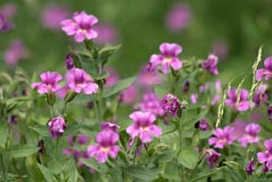 Lewis’ Monkeyflowers (Mimulus lewisii), Castle Crest Wildflower Garden, Photo by Robert Mutch
Plant List of the Castle Crest Wildflower Garden
Castle Crest Garden, Nature Notes From Crater Lake, 1929
Summer wildflower viewing, in the wet meadow, is the main goal here. This short, and relatively flat loop trail, passes through a forest, a dry slope, by a stream, and, the main attraction, a spring-fed meadow filled with wildflowers. The forest is composed of Mountain hemlock, Shasta red fir, Subalpine fir, and Lodgepole pine. During the summer months a profusion of wildflowers lines the pathway. Bring your wildflower identification book. Trail guides (A Trail Guide to Castle Crest by the Natural History Association of Crater Lake NP) are available at the trailhead for $.75 cents or for free if returned when you are finished with the trail.
Trailhead location:On the East Rim Drive, 0.5 miles from Park Headquarters; or, from a .25 mile path across the road from the Park Headquarters parking lot.
Historical Note: The Castle Crest Garden was established in 1929 with the planting of some 200 species of park flowers in the garden. The garden was meant as a learning area for wildflowers of the forest, wet meadows, and grassy slopes. There are several wet meadows throughout the park, but, none are easily accessible to the visitor.
Seasonal Information: Expect the trail to be covered in snow from October to early July, however, conditions vary somewhat from year to year.
Castle Crest Wildflower Wildflower Garden Trail Elevation Profile
Related Maps
Digital USGS topographic maps (PDF files) – the following maps are relevant to the Castle Crest Wildflower Garden trail. See more Crater Lake Institute online USGS digital maps.
| Series | Name | Year | Scale | Contour Interval | File Size |
| USGS 7.5′ | Crater Lake West | 1985 | 1:24,000 | 40 ft | usgs-crater-lake-west-7.5 |
| USGS 30′ x 60′ | Crater Lake | 1989 | 1:100,000 | 50 m | usgs-crater-lake-30-minute |
| USGS 30′ x 60′ | Diamond Lake | 1978 | 1:100,000 | 50 m | usgs-diamond-lake-30-minute |
| USGS 1° x 2° | Klamath Falls | 1970 | 1:250,000 | 200 ft | usgs-klamath-falls-1-2 |
| USGS 1° x 2° | Medford | 1976 | 1:250,000 | 200 ft | usgs-medford-1-2 |
| USGS 1° x 2° | Roseburg | 1970 | 1:250,000 | 200 ft | usgs-roseburg-1-2 |
(1) Forest – The surrounding forest is dominated by red fir and mountain hemlock. A smaller component of subalpine fir and short-needled lodgepole pine can also be found. This creates a dense canopy of heavy shade.
(2) Wet Meadow – In summer, a multitude of flowering plants, suited to moist soils and plenty of sunlight, flourish in the meadow. While lingering snowbanks melt, tiny violets and buttercups bloom, shooting stars unfurl pink darts, and bistorts display white florets. Verdant mosses claim the wet meadow center. Different species come into bloom throughout the season to change the meadow’s complexion.
In average winters, 50 feet of snow falls on Castle Crest’s slopes. Seeds, roots, and runners of a host of plants lie dormant beneath the snowpack. As spring arrives in June, new shoots push upward and willow branches sprout fresh leaves.
Through plant succession the meadow community is constantly changing as plants compete for sunlight and compete for sunlight and water. Willows encroach upon the meadow herbs. Red fir-mountain hemlock forest gradually replaces the willows. The forest can regenerate itself indefinitely under present climatic conditions. For now, Castle Crest Spring continues to bathe the roots of the pink monkeyflowers and other colorful mountain wildflowers.
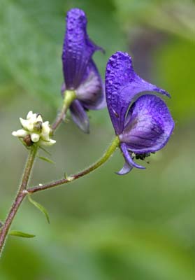
Look for these wildflowers: Gorman buttercup (Ranunculus gormanii), Shooting stars (Dodecatheon alpinum), American Bistort (Polygonum bistortoides), Pacific red elder (Sambucuc racemosa var. microbotrys), Scarlet paintbrush (Castilleja miniata), Eastwood willow (Salix eastwoodiae), Columbia monkshood (Aconitum columbainum), Pacific bleedingheart (Dicentra formosa), Arrowleaf groundsel (Senecio triangularis), Mountain Violet (Viola purpurea, var. venosa), Blue stickseed (Hackelia micrantaha), Lewis monkeyflower (Mimulus lewisii), Common pearl-everlasting (Anaphalis margaritacea)
(3) Dry Slopes – Before Mt. Mazama collapsed, the final eruptions 6,840 years ago hurled a pumice and loose rock mantle onto the slopes of the old volcano. The veneer is thin here, but is several hundred feet deep at Godfrey Glen, only 3 miles downslope.
Disintegration of this porous material has produced the mineral component of local soils. In this parched opening, plants adapted to a sunny, well-drained site pioneer: grasses, spreading phlox, skyrocket gilia, sulfur eriogonum, rabbitbrush goldenweed, and umbellate pussypaws. Watch for rufous hummingbirds here when the gilia blooms.
Just as wet area succession proceeds toward the red fir-mountain hemlock forest climax, this dry area community will eventually be engulfed by the forest. – A Trail Guide to Castle Crest
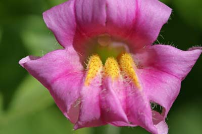
Lewis’ (or Pink) Monkey flower (Mimulus lewisii) at Castle Crest Wild Flower Garden, photo by Robert Mutch
|
Please remember to practice “leave no trace outdoor ethics” when you are out on Crater Lake National Park’s trails…and have fun! |
Other pages in this section
- Pacific Crest Trail
- Anderson Bluffs Trail
- Anne Creek Canyon Trail
- Anne Springs Cutoff Trail
- Bald Crater Loop Trail
- Bert Creek Trail
- Boundary Springs Trail
- Cleatwood Cove Trail
- Crater Peak Trail
- Discovery Point Trail
- Dutton Creek Trail
- Fumarole Bay Trail
- Garfield Peak Trail
- Godfrey Glenn Trail
- Lightning Spring Trail
- Llaos Hallway
- Mount Scott Trail
- Park Headquarters Historic Trail
- Pinnacles Valley Trail
- Plaikni Falls Trail
- Pumice Flat Trail
- Stuart Falls Trail
- Sun Notch Trail
- Union Peak Trail
- Watchman Peak Trail
- Wizard Island Summit Trail
- Hiking Rules and Regulations
- Best Trails at Crater Lake
